|
|
|
Wreck Pond
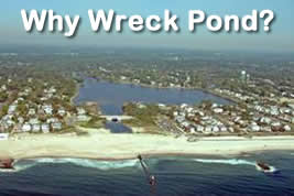
Wreck Pond is a coastal lake in Monmouth County that flourished with recreational activities such as fishing, crabbing, sailing, rowing, swimming and rafting in the 1960s. Over the past several decades, recreational activities have been limited to occasional crabbing due to water pollution from stormwater runoff and the filling in of the lake from sedimentation. When it rains this degraded water flows into nearby Spring Lake and Sea Girt beaches causing beach closings. The New Jersey Department of Environmental Protection (Department) is committed to restoring the Wreck Pond watershed, improving water quality and eliminating beach closings.
Wreck Pond Watershed is in southern Monmouth County and comprised of the following four municipalities: Wall Township; and the Boroughs of Spring Lake Heights, Spring Lake and Sea Girt. The watershed is approximately 12.8 square miles (8,172 acres), extending from the headwaters in Wall Township near Allaire Airport and flowing east-southeast to discharge into Wreck Pond. There are three major tributaries in the watershed: Hannabrand Brook; Wreck
Pond Brook; and Black Creek, as well as several other ponds. Wreck Pond is approximately 73 acres with tidal influence on the eastern portion. The eastern end of Wreck Pond contains an outfall structure that exchanges water with the Atlantic Ocean.
The main impairment of concern is bacteria which is affecting the water quality near the Spring Lake and Sea Girt bathing beaches. As a result of this impairment, Monmouth County Health Department instituted precautionary beach closings after 0.1” of rainfall. In addition, sediment and nutrient loading are contributing to eutrophication of the ponds and nutrient over enrichment of streams in the watershed exacerbating habitat loss and flooding. To address these impairments, the Department developed the Wreck Pond Restoration Action Plan in conjunction with the Wreck Pond Brook Watershed Regional Stormwater Management Plan Committee.
The Wreck Pond Restoration Action Plan is composed of the following action items:
- Action Item - Call for Research, Engineering Reports and Analytical Monitoring Data
See description.
Wreck Pond has received a significant amount of study over the years producing a vast amount of analytical monitoring data. The Department has identified and gathered research, engineering reports and existing analytical data on Wreck Pond Watershed. It's not too late to submit, if you have research studies or analytical data on Wreck Pond, please contact Sheri Shifren. Hide description.
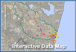
- Action Item - Website and Database Development
See description.
A Wreck Pond Watershed Restoration web site has been developed into a single source of information on the status of the project to be used by all entities involved in Wreck Pond including the public. The site houses all research and studies identified in Action Item 1 as well as a searchable custom database with all monitoring data. The site also spatially displays monitoring data on an interactive GIS map. The site assists in the coordination of activities, educational events and monitors progress. Hide description.
- Action Item – Infrastructure Mapping, Inspection, Assessment and Repair/Replacement
See description.
Municipalities within the Wreck Pond Watershed (Spring Lake, Sea Girt, Wall Township, and Spring Lake Heights) have supplied the Department with sanitary sewer and storm sewer system maps (including location of stormwater outfalls and any stormwater Best Management Practices) for their entire municipally owned system. In addition, the municipalities have supplied the Department with engineering reports summarizing results of inspections, video taping or smoke testing of the systems to determine its integrity and function.
Any gaps identified in mapping, inspection or assessment shall be resolved.
Action item goal is to identify areas within the storm sewer and/or sanitary sewer system that are failing, leaking, broken or otherwise not functioning as designed and have them repaired and/or replaced. Funding opportunities (grants, loans or partial grants/loan blends) will be identified in Action Item 7. A secondary goal is to have complete GIS coverage of the watershed’s sanitary and stormwater infrastructure (including Manufactured Treatment Devices) and to use this tool to identify areas within the system which may be contributing to the impairment. Hide description.
- Action Item – Identify, Fund and Replace Broken (privately owned) Laterals
See description.
Sewer laterals carry sanitary waste from private homes to the municipal sanitary sewer and are the responsibility of the individual homeowner. It is suspected that many of the older homes in Sea Girt and Spring Lake have broken or cracked laterals. Sewage from these laterals leak into the sandy soil and easily infiltrates, during storm events, into broken, cracked or poorly grouted storm sewer pipes. While the municipality is responsible for repairs to the municipal separate storm sewer, homeowners are liable for the cost of replacing broken laterals.
Action item goal is to identify and repair broken laterals, prioritizing suspected problem areas such as Ocean Ave in Spring Lake and Baltimore Blvd. in Sea Girt. Once broken laterals are identified, homeowners may be directed to repair or replace broken laterals at their own expense or municipalities may consider pass through funding using outside sources.
Hide description.
- Action Item – Monitoring Plan / Microbial Source Tracking
See description.
A thorough review and assessment of all monitoring data collected (Action Item 1) shall be completed. Monitoring points and data will be displayed on a GIS map of the watershed along with sanitary sewer and storm sewer systems (Action Items 2 & 3). Any gaps in monitoring data will become part of a monitoring plan. All existing data evaluated and future monitoring will build on prior studies. Use proven techniques such as optical brighteners, antibiotic resistance, coliphage and new techniques such as Quantitative Polymerase Chain Reaction (qPCR) to identify sources of bacteria.
Action item goal is to design and implement intensive monitoring based on existing data and pollution source surveys (Action Item 7). Data needed includes quality, quantity, salinity (mixing) and hydrologic response. A clear understanding of how the watershed responds (during storm events) including the time of travel of stormwater from the upper watershed to the ocean outfall and the bacterial load during the duration of the event. This data will help determine the extent of the impairment within the watershed. Implement corrective actions and follow-up monitoring to determine effectiveness of corrective actions.
Hide description.
- Action Item – Identifying Sources of Funding / Wreck Pond Brook Watershed Regional Restoration Plan
See description.
Potential funding sources shall be identified such as EPA (EPA CARE grants), Section 319(h) watershed restoration grants, Clean Water NJ funds, Infrastructure Trust loan/grant to fund capital improvements (sanitary and storm sewer upgrades Action Item 3), replacement and repair of sewer laterals (Action Item 4), infrastructure inspection (video of sanitary sewer lines and laterals), and education and outreach (Action Item 8). Green Acres funding could potentially be used for purchase of stream buffers in upper watershed (Action Item 7).
Eligibility for 319 funds is partly contingent on the Wreck Pond Brook Watershed Regional Plan/Watershed Based Implementation Plan being approved by NJDEP Division of Water Monitoring and Standards, Bureau of Environmental Analysis, Restoration and Standards. A goal of Action Item 6 is to ensure that the restoration plan is approved.
Hide description.
- Action Item – Identifying Land Use Cover/ Preserving Buffers in Upper Watershed
See description.
One of the most important factors that can affect the quality of a surface-water body is the land use within its watershed. Using GIS satellite imagery, existing GIS Land Use Coverage layers and ground truthing (pollution source surveys), identify land uses and how those land uses may contribute to impairment of the Wreck Pond Watershed. Identify and inspect Animal Feeding Operations (horse, cattle, and poultry farms) to ensure proper nutrient management plans are in effect. Use GIS to identify parcels of open space available to preserve stream buffers in the upper watershed.
Hide description.
- Action Item – Public Outreach and Education
See description.
Develop and expand a public education and outreach program within the watershed to target permanent residents, summer residents and vacationers. Effectively communicate impacts of non-point source pollution and how individual’s actions affect water quality. Leverage the Wreck Pond Brook Watershed Committee’s existing public education campaign. Apply for EPA’s CARE grant. Work with municipalities to post educational information on beaches and pass out information with beach badges. Accelerate public education campaign for summer 2012. Hide description.
- Action Item – Identify and Implement Watershed Restoration/Water Quality Projects
See description.
Identify and implement watershed restoration and water quality/quantity projects to improve overall water quality within the Wreck Pond Brook Watershed. Projects should address one or more of the following pollutants of concern: pathogens/bacteria, suspended solids, nutrients and/or quantity.
Assist Monmouth County with the implementation of plans to dredge parts of the Wreck Pond Watershed and identify other areas for localized dredging. Investigate the feasibility and cost of larger scale dredging project and sources of funding. Further study the sediments in Wreck Pond and whether they contribute to elevated bacteria levels. Investigate whether dredging would help in the restoration of the watershed?
Hide description.
- Action Item – Flood Control
See description.
Superstorm Sandy breached the sand dune revealing an emergency spillway for Wreck Pond. The emergency spillway eliminates the need for a permanent pump system. A DEP Beach and Dune Maintenance Permit and Emergency Authorization allows for temporary excavation and re-grading of sand to the east of the spillway in an emergency flooding situation. The emergency spillway is able to discharge the water from the pond when it reaches an elevation of 2.5 feet above sea level. This alleviates flooding. During a coastal surge it is necessary to prevent the ocean tidal water from filling the pond. Spring Lake is exploring a sluice gate to prevent the coastal surge. Spring Lake and NJDEP are also exploring the incorporation of a berm around certain areas of Wreck Pond of 18-2 to prevent flooding as part of the living shoreline project.
Hide description.
- Action Item – Increase Tidal Influence/Mixing
See description.
Investigate the effects the Wreck pond outfall extension had on the tidal flow and mixing within Wreck Pond. Study whether the change had a detrimental effect on pond health and whether changes to promote more tidal influence and mixing would improve conditions and help restore the water body. The existing outlet structure may restrict flows into, and out of, the watershed. This delayed response prevents rapid mixing of stormwater with the ocean during and after a rain event and results in negative water quality from the storm to impact localized beaches over a longer time period (48-72 hours).
The action item goal is to restore a natural tidal exchange between Atlantic Ocean, Wreck Pond, Black Creek, and other appropriate areas of the watershed while balancing the need for flood protection, including analyzing the effectiveness of the outfall structure.
Hide description.
- Action Item – One Vision / One Goal
See description.
One Vision / One Goal, replace text with: Improve communications within the Department to ensure all Divisions with a stake in the Wreck Pond watershed restoration efforts have a clear vision and understanding of the Commissioners goal of improving water quality within the Watershed and to resolve impairments contributing to the regular closings of beaches to recreational bathing in Sea Girt and Spring Lake.
Improve communications, involvement and establish partnerships with the four municipalities within the Wreck Pond Watershed (Spring Lake, Sea Girt, Wall Township, and Spring Lake Heights). Work through the Office of Local Government Assistance to establish relationships with Mayors and Administrators to ensure that we all share the same environmental outcome for their local resource. Continue to update and communicate progress to Senator Singer, Assemblyman Kean and Assemblyman Ribles office through Deputy Chief of Staff.
Improve communications and establish partnerships with external stakeholders, including Wreck Pond Brook Watershed Committee, Clean Ocean Action, Monmouth County Planning Board, Rutgers University, Army Corp of Engineers, consultants, Freehold Soil Conservation District, Monmouth University, Monmouth County Health Department, Monmouth County Regional Health Commission, NJ DOT, and local residents to clearly and transparently communicate our regional watershed approach with one vision and one goal: to improve water quality.
Hide description.
Click here for a copy of the full Wreck Pond Restoration Action Plan, including: completed milestones, next steps and implementation schedule.
The following is a list of agencies, educational institutions and firms that have partnered with the Department to accomplish the goal of improving water quality within the Watershed and resolving impairments contributing to the precautionary closings of Spring Lake and Sea Girt recreational bathing beaches:
- AECOM
- American Littoral Society
- Borough of Sea Girt
- Borough of Spring Lake
- Borough of Spring Lake Heights
- Clean Ocean Action
- Columbia University
- Environmental Resource Management
- Freehold Soil Conservation District
- Leon S Avakian, Inc.
- Monmouth Conservation Foundation
- Monmouth County Division of Engineering
- Monmouth County Health Department
- Monmouth County Mosquito Extermination Commission
- Monmouth County Office of Emergency Management
- Monmouth County Office of GIS
- Monmouth County Planning Board
- Monmouth County Public Works
- Monmouth County Regional Health Commission
- Monmouth University
- Najarian Associates
- NJ Department of Agriculture
- Omni Environmental LLC
- Rutgers Cooperative Extension
- Surfers Environmental Alliance
- South Monmouth Regional Sewerage Authority
- T & M Associates
- US Army Corp of Engineers
- US Fish and Wildlife Service
- Wall Township
- Wall Township Environmental Advisory Committee
- Wreck Pond Brook Watershed Regional Stormwater Management Plan Committee
- Wreck Pond Brook Watershed Technical Advisory Committee
- Wreck Pond Homeowners Alliance
|