Home > Basin Information > Photo Gallery > Fall Photo Gallery
Fall Photo Gallery

Bridge Between Two Seasons by Kevin Haines, winner of DRBC's Fall 2018 Delaware Basin Photo Contest.
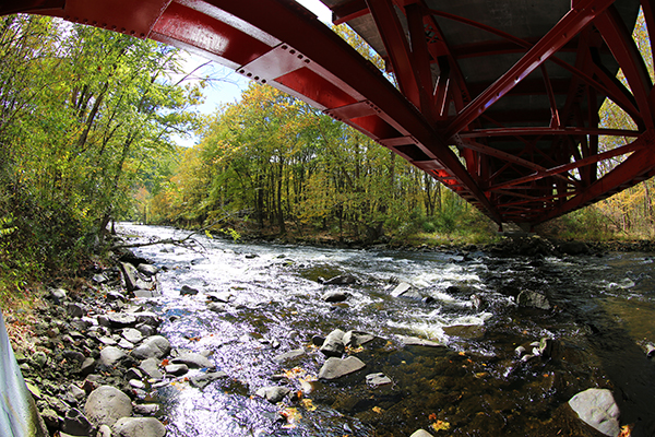
Bridge Between Two Seasons by Kevin Haines.
This photo was the winner of DRBC's Fall 2018 Photo Contest.

View of the Tacony-Palmyra Birdge from NE Philadelphia's Lardner's Point Park by DRBC Government Affairs Lead Stacey Mulholland. This photo was the winner of DRBC's Staff Fall 2018 Photo Contest.Rapids on the Mongaup in the Fall by Andy Smith. This photo was the winner of DRBC's Fall 2017 Delaware Basin Photo Contest.Delaware River (looking down-river) at Kilgour Spur, which is just up-river of Lordville, New York/Eqinunk, Pennsylvania. Photo courtesy of Dave Soete.Fall foliage at Beltzville State Park, Carbon County, Pa. The park was developed as part of an U.S. Army Corps of Engineers flood control project, which dammed the Pohopoco Creek, a tributary to the Lehigh River. The dam, which is visible on the far right, created Beltzville Lake (or Reservoir), which is utilized for flood control, recreation, and water supply. DRBC owns water supply storage in the lake, which is used to augment the Delaware River in times of low flow. Photo by DRBC.  The Brandywine Creek travels through Pennsylvania's Chester and Delaware Counties before emptying into the Christina River in Wilmington, Delaware. The creek played several important roles in American history; for example, its paper mills supplied paper to print the Declaration of Independence. Brandywine Creek State Park in Wilmington was created in 1965 from a dairy farm once owned by the du Pont family. Photo from the DRBC Collection.A tree's changing leaves are reflected in New Jersey's Delaware and Raritan (D&R) Canal. The D&R Canal connects the Delaware and Raritan Rivers; originally used for transportation, the canal now serves as water supply. In 1974, over 60-miles of the canal and adjacent land were made a state park, the D&R Canal State Park. Photo by DRBC.A man and his horse out for a peaceful stroll along the towpath of Pennsylvania's Delaware Canal. The canal runs parallel to the Delaware River for 60-miles from Easton, Pa. to Bristol, Pa. The canal and towpath make up Pennsylvania's Delaware Canal State Park and are also a National Historic Landmark (canal) and National Recreation Trail (towpath). Photo by DRBC.An American flag flies in the fall winds atop of Mount Tammany on the N.J. side of the Delaware Water Gap National Recreation Area. Below, Arrow Island in the Delaware River is just downstream from where Interstate-80 crosses the river and marks the southern terminus of the National Recreation Area. Photo courtesy of Steve Klaver Photos LLC.A peaceful, fall day on the Delaware River. Photo from the DRBC Collection.Fog rises off the Delaware River near the National Park Service Upper Delaware Scenic and Recreational River's Barryville, New York office. Photo courtesy of Sandy Schultz.
View of the Upper Delaware River and the season's changing colors from Hawk's Nest Overlook, N.Y. The overlook is off of N.Y. State Route 97 near the town of Deerpark and is part of the Upper Delaware Scenic Byway. Photo from the DRBC Collection.View of a November sunset over New Hope, Pa. from Goat Hill Overlook, N.J. The overlook is accessed via an approx. 1/2 mile trail that is maintained as part of nearby Washington Crossing State Park in N.J. The land was preserved for public use through N.J.'s Green Acres program; local legend has it that George Washington once used the overlook to view the Delaware River. Photo by DRBC.Rock climbers scale Mount Tammany on the N.J. side of the Delaware Water Gap National Recreation Area. Mount Tammany is named after the Lenape Chief Tamanend, who - with William Penn - helped establish peaceful relations between Native American tribes and the English settlers of Pennsylvania. Photo courtesy of Steve Klaver Photos LLC.October view of the Delaware River at Narrowsburg, N.Y. This section of river is known as the Big Eddy, a popular fishing spot year-round and the deepest part of the non-tidal Delaware River. Photo courtesy of Dave Soete.View of historic Washington's Crossing, Pa. The flagship appeared soon after September 11, 2001; one of the replica Durham boats used in the Christmas Day reenactments of George Washington's crossing of the Delaware River is moored on the shoreline. Photo taken in November 2001 by DRBC.Upstream view of the Delaware River from Prallsville Mills, Stockton, N.J. The Prallsville Mills Complex is part of the D&R Canal State Park and is operated and maintained by the Delaware River Mill Society. Photo by DRBC.Whitewater rapids on the Upper Delaware River provide a sharp contrast to the season's changing leaves. Photo from the DRBC Collection.The Delaware River, as seen from Hawk's Nest Overlook off of N.Y. State Route 97, in October. Named after the birds that are spotted most frequently, the overlook provides stunning views via several motorist pull-offs. Photo by DRBC.A quiet, foggy October day along the Middle Delaware River at the Shawnee Inn and Golf Resort, Shawnee-on-Delaware, Pa. Located in the Delaware Water Gap National Recreation Area, the Inn celebrated its 100th Anniversary in 2011. Photo courtesy of Dave Soete.
Boats in their slips at the marina on Lake Nockamixon, Nockamixon State Park, Quakertown, Pa. The 1,450 acre lake has four public launching areas and is popular with motorboats, sailboats, catamarans, and kayaks. Photo by DRBC.October view of the Delaware River at Washington's Crossing, Pa. This photo was taken on the grounds of the Washington Crossing Historic Park, a 500-acre site operated by the Pennsylvania Historical and Museum Commission in partnership with the Friends Of Washington Crossing Park. Photo by DRBC.Campers prepare for a cool, fall night in the Delaware Water Gap National Recreation Area (DWGNRA) overlooking the wild and scenic Delaware River. DWGNRA is one of the top ten most visited national parks in the U.S. Photo courtesy of Steve Klaver Photos LLC.Fall's multi-color hues are reflected in the still waters of the Upper Delaware River near Barryville, N.Y. Photo courtesy of Sandy Schultz.Downstream view of the Delaware River, taken from the New Hope (Pa.) - Lambertville (N.J.) Toll Supported Bridge. This section of river is part of the Lower Delaware National Wild and Scenic River, which is a unit of the National Park Service. Photo by DRBC.The reds and oranges of deciduous trees provide brilliant pops of color amongst the evergreens along the Lackawaxen River, a tributary to the Delaware River. The Lackawaxen flows for 31.3 miles from its source in Prompton, western Wayne County, Pa., through the northern Pocono Mountains region, to its confluence with the Delaware at  Lackawaxen, Pa. in Pike County. Photo courtesy of Dave Soete.Confluence of the Wickecheoke Creek and the Delaware River at Prallsville Mills, Stockton, N.J. The Wickecheoke Creek is 15-miles long, and much of its surrounding lands are part of the New Jersey Conservation Foundation's Wickecheoke Creek Preserve. Photo by DRBC.October sunset over the Delaware River at New Hope, Pa. Photo by DRBC.
Other Photo Galleries

Please note: If you would like to use a photo from one of these galleries, send us an email with your request, noting the image(s) you are interested in. Thank you.