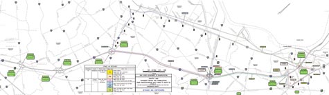
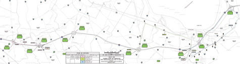
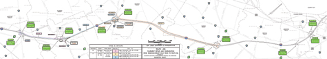
Detours
Within the
project limits there are
five interchanges and numerous
ramps. Most of the ramps
will be reconstructed adjacent
to I-295 with the remaining
portions milled and resurfaced.
The files below are
in Portable Document Format
(PDF). You will need Adobe
Acrobat Reader, which is
available free from the state
Adobe Access page, to
view the files.
| Stage
4: early August to
mid September 2010*
-
Completed |
| Stage
4a: |
| Location |
Closure |
Duration |
| Interchange
57 |
Route
206/130 south
on-ramps to I-295 south
Detour
map 10 (pdf
146k)
Take
Route 206 south
to right at Connector
Road, right at
Rising Sun Road,
then left on ramp
to I-295 south.
|
Completed |
| |
|
|
| |
Route
206/130 south
on-ramps to I-295 south
Secondary detour map 10b (pdf
135k)
Take
Route 130 south
to
I-295 south (Collector-Distributor
Road that is parallel with Route
130) to Route 130 north (double
loop ramp U-turn), then right at
County Route 545/Farnsworth Avenue,
right at Route 206 south, right
at Connector Road, right at Rising
Sun Road, then left on ramp to
I-295 south. |
Completed |
| |
|
|
| Interchange
52 |
I-295
south off-ramps to
Florence-Columbus Road east and
west (County Route 656)
Detour
map 11 (pdf
136k)
Continue
on I-295 south to Exit 47A
(County Route 541/ Burlington-Mount
Holly Road) then ramp to
I-295 north (double loop
ramp
U-turn) back to Exits 52A-B. |
Completed |
| |
|
|
| |
Florence-Columbus
Road east (County Route
656) on-ramps to I-295
south
Detour
map 12 (pdf
160k)
Take ramps
to I-295 north to Exit 56
(Rising Sun Road), then make
left and over bridge to make
left on ramp to I-295 south
to
Exit 52B-A. |
Completed |
| |
|
|
| |
Florence-Columbus
Road west (County Route
656) on-ramp to I-295
south
Secondary
Detour map 12b (pdf
152k)
Take Florence-Columbus
Road west (County Route 656)
to Route 130. Make left onto
Route 130 south and continue
for 4.4 miles, then make left
onto Jacksonville Road (County
Route 670). Continue on Jacksonville
Road to second traffic signal
and make right onto Burlington
Bypass (County Route 541T), then
make right onto Sunset Road,
then make left onto Burlington-Mount
Holly Road (County Route 541).
Stay in right lane and take ramp
onto I-295 south. |
Completed |
| |
|
|
| |
I-295 south off-ramp
(for
truck U-turn to I-295 north to
Petro and Pilot truck stops)
Detour
map 13 (pdf
170k)
Take Exit
57B (Route 130 south, Burlington),
then Route 130 south to left
turn at Florence-Columbus
Road/County Route 656, then
ramp to I-295 north (at Interchange
52) to Rising Sun Road (Exit
56). |
Completed |
| |
|
|
All
detours for Stage 4a (pdf
17.8m)
| Stage
4b: |
| Location |
Closure |
Duration |
| Interchange
57 |
Route
130 south
on-ramp to I-295 south
Detour
map 14 (pdf
165k)
Take
Route 130
south to
left turn
at Florence-Columbus
Road/County
Route 656,
then ramp
to I-295
south (at
Interchange
52).
|
Completed |
| |
|
|
| Interchange
56 |
Rising
Sun Road west
on-ramp to I-295 south
Detour
map 15 (pdf
164k)
Take Rising
Sun Road west to Route 130
north to U-turn at Dunns
Mill Road jughandle to Route
130 south to left at Florence-Columbus
Road/County Route 656 to
I-295 south (at Interchange
52). |
Completed |
| |
|
|
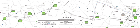
All
detours for Stage 4b (pdf
10.2m)
| Stage
4c: |
| Location |
Closure |
Duration |
| Interchange
57 |
Route
130 south
on-ramp to I-295 south
Detour
map 14 (pdf
165k)
Take Route
130 south to left turn at Florence-Columbus
Road/County Route 656, then ramp
to I-295 south (at Interchange
52).
|
Completed |
| |
|
|
| Interchange
47 |
I-295
south off-ramps to
Burlington-Mount Holly Road east
and west (County Route 541)
Detour
map 16 (pdf
132k)
Continue
on I-295 south to Exit 45A
(Beverly-Rancocas Road/County
Route 626), then ramp to
I-295 north (double loop
ramp U-turn) back to Exits
47A-B. |
Completed |
| |
|
|
| |
Burlington-Mount
Holly Road east and
west (County Route 541)
on-ramps to I-295 south
Detour
map 17 (pdf
126k)
Take ramp
to Exit 52B (Florence-Columbus
Road/County Route 656 towards
Florence) then take ramp
to I-295 south (double loop
ramp U-turn). |
Completed |
| |
|
|
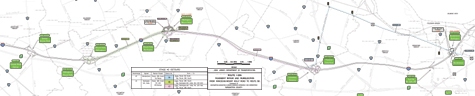
All
detours for Stage 4c (pdf
10.4m)
| Stage
2: mid June 2010
to late July 2010*
- Completed |
| Stage
2a: |
| Location |
Closure |
Duration |
| Interchange
45 |
Rancocas-Mount
Holly Road east and
west (County Route 626)
on-ramps to
I-295 north
Detour
map 2 (pdf
133k)
Take ramp
to I-295
south to
Exit 43A
(Creek
Road/County
Route 636
east, Rancocas
Woods),
then take
ramp to
I-295 north
(double
loop ramp
U-turn). |
Completed |
| |
| Interchange
52 |
I-295
north off-ramps to
Florence-Columbus Road east and
west (County Route 656)
Detour
map 3 (pdf
159k)
Continue on I-295 north to
Exit 56 (Rising Sun Road),
then make left and over bridge
to make left on ramp to I-295
south to Exit 52B-A. |
Completed |
| |
| |
Florence-Columbus
Road west (County Route
656) on-ramp to
I-295 north
Detour
map 4 (pdf
166k)
Continue on Florence-Columbus
Road (County Route 656) to Route
130 north, make right and stay
on Route 130 north to I-295 north
entrance ramp at Interchange 57.
Signs on Route 130 north approaching
Florence-Columbus Road will direct
traffic bound for the Truck Stop
to continue on Route 130 north
to Rising Sun Road. |
Completed |
| |
| |
Florence-Columbus
Road east (County Route
656)
on-ramp to
I-295 north
Detour
map 5 (pdf
127k)
Take ramps to
I-295 south to Exit 47A, then ramp
to I-295 north (double loop ramp
U-turn). |
Completed |
| |
| |
I-295
north on-ramp (for
truck U-turn from I-295
south to I-295
north to Petro and Pilot truck
stops)
Detour
map 6 (pdf
170k)
Continue
on I-295 south to Exit 52A
(Florence-Columbus Road/County
Route 656 toward Florence),
then County Route 656 to
Route 130 north, make right
and stay on Route 130 north
to Rising Sun Road. |
Completed |
All detours for Stage 2a (pdf
5.3m)
| Stage
2b: |
| Location |
Closure |
Duration |
| Interchange
45 |
Rancocas-Mount
Holly Road east and
west (County Route 626)
on-ramps to
I-295 north
Detour
map 2 (pdf
133k)
Take
ramp to I-295 south to
Exit 43A (Creek Road/County
Route 636 east, Rancocas
Woods), then take ramp
to I-295 north (double
loop ramp U-turn). |
Completed |
| |
| Interchange
56 |
I-295
north off-ramp to
Rising Sun Road east and west
Primary
detour map 7
(pdf
164k)
I-295
north to Exit 52B (Florence-Columbus
Road/County Route 656 towards Florence),
then Florence-Columbus Road to
Route 130 north, make right and
stay on Route 130 north to Rising
Sun Road. |
Completed |
| |
| |
I-295
north off-ramp to Rising
Sun Road east and west
Secondary
detour
map 7b
(pdf
167k)
Continue
on I-295
north to
Exit 60,
then I-195
east (Shore
Points),
Route 206
south to
right at
Connector
Road, then
right at
Rising
Sun Road. |
Completed |
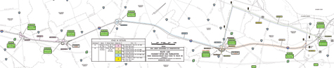
All detours for Stage 2b (pdf
18.9m)
| Stage
2c: |
| Location |
Closure |
Duration |
| Interchange
45 |
Rancocas-Mount
Holly Road east and
west (County Route 626)
on-ramps to
I-295 north
Detour
map 2 (pdf
133k)
Take
ramp to I-295 south to
Exit 43A (Creek Road/County
Route 636 east, Rancocas
Woods), then take ramp
to I-295 north (double
loop ramp U-turn). |
Completed |
| |
| Interchange
47 |
I-295
north off-ramps to
Burlington-Mount Holly Road east
and west (County Route 541)
Detour
map 8 (pdf
135k)
Continue on I-295 north to Exit
52B (Florence-Columbus Road/County
Route 656 toward Florence) then
ramp to I-295 south (double loop
ramp U-turn) back to Exits 47B-A. |
Completed |
| |
| |
Burlington-Mount
Holly Road east and
west (County Route 541)
on-ramps to I-295 north
Detour
map 9 (pdf
154k)
Take ramp to I-295
south, past Exits
45B-A to Exit
43A (Creek Road/County
Route 636 east,
Rancocas Woods),
then ramp to I-295
north (double
loop ramp U-turn). |
Completed |
| |
All
detours for Stage 2c (pdf
11.9m)
| Stage
1: February 2010 to
mid June 2010* - Completed |
| Stage
1b: |
| Location |
Closure |
Duration |
| Interchange
57 |
I-295
north off-ramp to
Route 130 north
Detour
map 1 (pdf
165k)
Continue
on I-295 north
to Exit 60, then
I-195 east (Shore
Points), Route
206 south, Route
130 south to ramps
for I-295 south
(Collector-Distributor
Road that is parallel
with Route 130)
to Route 130 north
(double loop ramp
U-turn). |
Completed |
*All
schedules are subject to
change and are dependant
on weather, suppliers, partner
schedules and other variables.
|