Electromagnetic Methods (EM)
Electromagnetic methods (EM) measure electrical currents generated in the
subsurface resulting from the induction of time-varying magnetic fields at
the ground surface. The EM method measures the bulk conductivity of subsurface
material beneath and between the instruments transmitter and receiver coils.
The readings are commonly expressed in the conductivity units of milli-ohms/meter
(m-ohms/m) or milliseimens/meter (mS/m). EM Surveys are used for locating
subsurface zones of highly-fractured bedrock, buried steel drums and tanks,
plumes of ground-water contamination, and clay-rich horizons.
Terrain Conductivity
The terrain conductivity method uses co-planar transmitter and receiver coils
with fixed separation. The exploration depth is generally increased by increasing
the coil separation. The data are recorded in the frequency domain. Current
flowing through the transmitter coil is set at a fixed frequency that varies
as a sinusoidal function with time. Most EM instruments measure both the
in-phase (real) and out-of-phase (quadrature) field components which are
oriented normal to each other within the induced or primary magnetic field.
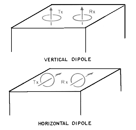
Diagram illustrating the coil configuration of a terrain conductivity
study. Tx - transmitter coil, Rx - receiver coil.

Terrain conductivity and in-phase EM data over buried drain pipe and
tank.
Transient EM (TEM)
The "transient" or "time-domain" EM method records data in the time domain.
The electrical current is induced for a period of time necessary to create
a steady-state megnetic field in the earth. After this current is shut off,
the secondary magnetic field associated with the induced current is sampled
at a receiver as a function of time.
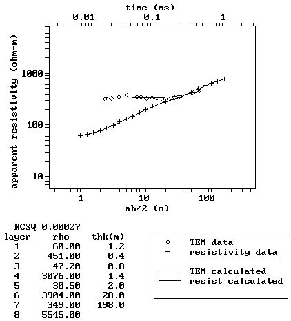
A modified display of the computer-graphics available with NJGS Open-File
Report OFR 88-1 (Microcomputer Software for the Processing and Forward Modeling
of Transient Electromagnetic Data Taken in the Central Loop Sounding
Configuration).
Ground Penetrating Radar (GPR)
The GPR method uses a transmitting antenna to emit pulses of high-frequency
EM waves into the subsurface. A transmitter and receiver apparatus is moved
across the ground and the reflected EM energy is recorded as a function of
time.
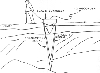
Diagram illustrating components of a GPR survey.
Very Low Frequency EM (VLF-EM)
The very-low frequency (VLF) EM method detects conductors by utilizing radio
signals in the 15 to 30 kilohertz (kH) range that are used for military
communications. The VLF transmitting stations are located worldwide. The
most commonly used stations in North America are Annopolis, Maryland (21.4
kH), Cutler, Maine (24.0 kH) and Seattle, Washington (24.8 kH). Both of the
in-phase (real) and out-of-phase (quadrature) components of the induced magnetic
field are measured.
For more information on electrical methods, please refer to
Chapter 8 (Geophysical Techniques) of the
NJDEP's Field Sampling Procedures Manual, 2005.
|