Delaware • New Jersey • Pennsylvania
New York • United States of America
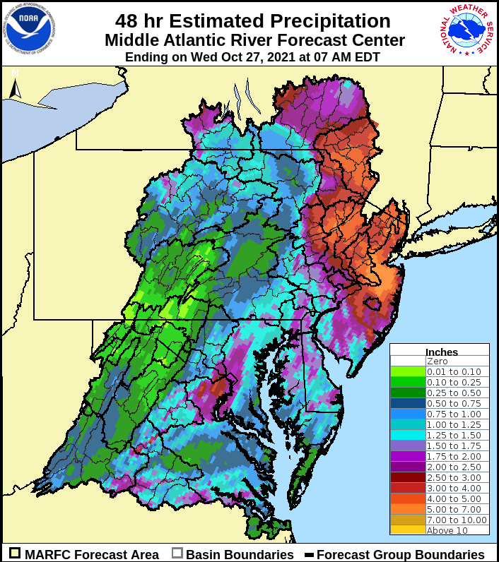
Over the past 48 hours, many locations in the basin north of Philadelphia have received between 3-5 inches of rain with higher amounts in the upper basin and along the main stem (see graphic below). As with any high intensity rainfall event, flash flooding in small streams and flood-prone, low-lying and/or urban areas was also a concern.
The DRBC has been monitoring this recent rainfall event and how it is impacting the Delaware River Basin with respect to flooding. We have compiled the following information from the National Weather Service for the Delaware River Basin. Please note that the DRBC does not issue flood forecasts, advisories or flood warnings.
Flood forecasts are from the National Weather Service’s Advanced Hydrologic Prediction Service (NWS AHPS). Visit https://water.weather.gov/ahps/region.php?rfc=marfc to view more detailed information. Forecasts are current as of this morning and are anticipated to be updated every 6-12 hours.
Please note: More rain is expected later in the week, and additional flooding on Friday and Saturday may result. DRBC staff will provide updates if flooding is expected to occur.
Upper Basin:
- MODERATE FLOODING occurred on the Delaware River at Callicoon; the river is receding and is currently in ACTION STAGE.
- MINOR FLOODING occurred on the Delaware River at Barryville, on the West Branch Delaware River at Walton, the East Branch Delaware River at Fishs Eddy and the Beaver Kill at Cooks Falls. The West Branch at Walton and the Delaware River at Barryville are currently in ACTION STAGE; the other locations are currently experiencing no flooding.
- ACTION STAGE flooding was experienced at the East Branch Delaware River at Harvard, the West Branch Delaware River at Hale Eddy and the Neversink River at Godeffroy. These locations are currently experiencing no flooding.
- ACTION STAGE flooding is occurring on the Lackawaxen River at Hawley, the Dyberry Creek in Honesdale and the Brodhead Creek at Minisink Hills.
- High river rises are anticipated elsewhere.
- The Cannonsville and Pepacton reservoirs are not expected to spill; the Neversink reservoir is predicted to spill later this evening.
Main Stem Non-Tidal Delaware River:
- MODERATE FLOODING is predicted at Tock’s Island (Delaware Water Gap).
- MINOR FLOODING is predicted for Easton, Riegelsville, Frenchtown, Stockton, New Hope – Lambertville, Washington Crossing and Trenton.
- ACTION STAGE is predicted at Belvidere.
Northwest New Jersey Tributaries:
- ACTION STAGE to MINOR FLOODING is occurring for some locations on the Paulins Kill, the Pequest River and the Flat Brook.
Tidal Locations:
- MODERATE FLOODING is forecast for the Delaware River at Burlington and at Washington Street and for the Delaware Bay at Reedy Point and Lewes-Cape May, as well as for the Murderkill River at Bowers Beach, Del.
- The Maurice River at Bivalve, N.J. is expected to reach MINOR FLOODING.
- The information provided herein was developed by the National Weather Service and Middle Atlantic River Forecast Center.
- All forecasts are subject to change, including storm track, precipitation amounts, predicted stage and crest timing.
- During storm events, we recommend everyone keep a close eye on real-time information from the NWS, NOAA weather radio, local TV, radio, apps – however you get your weather info.
- Please be on alert for rising water levels and follow instructions of state, county, or local emergency management, first responders, or law enforcement personnel. Note that the DRBC does not issue flood evacuations.
- Please do not travel on flooded roadways. Turn around, don’t drown!
- A link to detailed NWS flood stage definitions can be found in the next section, but in brief:
- No Flooding (green) – river/stream below level where flooding becomes a concern.
- Near Flood/Action Stage (yellow) – flooding becomes a concern. River/stream is approaching or is forecast to approach the gage height – flood stage – where flooding is defined to begin. Flood stage is an established gage height for a given location at which a rise in water surface level begins to create a hazard to lives, property, or commerce.
- Minor Flooding (orange) - minimal or no property damage, but possibly some public threat.
- Moderate Flooding (red) - some inundation of structures and roads near stream. Some evacuations of people and/or transfer of property to higher elevations.
- Major Flooding (violet) - extensive inundation of structures and roads. Significant evacuations of people and/or transfer of property to higher elevations.
- No Flooding (green) – river/stream below level where flooding becomes a concern.
- NWS Middle Atlantic River Forecast Center: https://www.weather.gov/marfc
- NWS Mt. Holly: https://www.weather.gov/phi
- NWS Binghamton: https://www.weather.gov/bgm
- NWS Flood Stage Definitions https://www.weather.gov/aprfc/terminology
- New Jersey Office of Emergency Management (NJOEM): http://www.ready.nj.gov/
- Pennsylvania Emergency Management Agency (PEMA): https://www.pema.pa.gov/Pages/default.aspx
- Delaware Emergency Management Agency (DEMA): https://dema.delaware.gov/
- New York State Emergency Management (NYS OEM): http://www.dhses.ny.gov/oem/
- DRBC Flood Portal: https://www.nj.gov/drbc/programs/flood/portal-flood.html
- DRBC Hydrosnap Dashboard (Updated Daily)
- Flexible Flow Management Program