Delaware • New Jersey • Pennsylvania
New York • United States of America
- Please Note
- Delaware River Recreation Map Set
- Schuylkill River Recreation Map Set
- Ordering Information
Delaware and/or Schuylkill River Recreation Map Sets are Available for Order Online or by Mail!
The DRBC offers two sets of recreation maps for purchase: the Delaware River Recreation Map Set and the Schuylkill River Recreation Map Set. If you paddle, fish, or boat the Delaware and/or Schuylkill rivers, these map sets are for you!
Prices and ordering information appear below the map set descriptions (or click 'ordering information' above).
The Delaware River Recreation Maps are a 10-section, waterproof map set that covers the river's east and west branches prior to their confluence at Hancock, New York, the entire 200 mile, non-tidal reach of the river from Hancock to Trenton, New Jersey and an additional 25 miles of the tidal river from Trenton to just south of the Betsy Ross Bridge (which connects Northeast Philadelphia, Pa. and Pennsauken, N.J.).
The maps depict river channel locations and depths, access areas, places of interest, stream miles and reference points, and provide a detailed Classification of streamflow characteristics in accordance with the International Canoe Federation's Scale of River Difficulty. While these maps show river depths and rapids' classifications, it is important to remember that actual river conditions may vary. DRBC encourages paddlers to be aware of current weather and river conditions and always wear a personal flotation device (PFD).
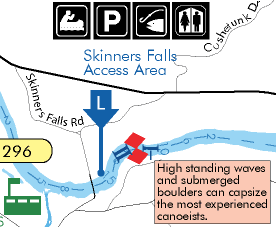
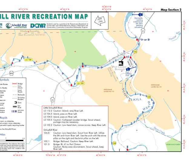
The 10-map set, published in 2003, includes portions of the Little Schuylkill River, West Branch Schuylkill River and the main stem Schuylkill River from Port Clinton to the Delaware River in southeastern Pennsylvania.
These full-color, waterproof river maps identify public access areas, International Canoe Federation/American Whitewater Affiliation-designated streamflow characteristics, areas of caution, dams and pools, and recreation opportunities. While these maps show river depths and rapids' classifications, it is important to remember that actual river conditions may vary. DRBC encourages paddlers to be aware of current weather and river conditions and always wear a personal flotation device (PFD).
In addition to these maps, check out the Schuylkill River Water Trail, maintained by Schuylkill River Greenways.
Recreation Map Set Prices:
- Delaware River Recreation Maps: $10 plus tax = $10.70/set.
- Schuylkill River Recreation Maps: $5 plus tax = $5.35/set.
- Prices also include shipping/handling.
- For agencies and organizations that are tax exempt, please contact us for instructions on how to place your order.
- A portion of the proceeds from the sale of the Delaware River Recreation Maps will help fund the Commission's educational/outreach programs and activities.
How to Order Recreation Maps:
- Order by mailing in check payment or money order.
- Order online via PayPal or major credit card.
Check/Money Order by Mail:
- If ordering Delaware River or Schuylkill River Recreation Maps, please download the order form (PDF; archive), fill out completely, and send in with payment.
- Please note on your check how many of each map set you are ordering.
- Please make check/money order payable to: Delaware River Basin Commission, P.O. Box 7360, 25 State Police Drive, West Trenton, NJ 08628-0360.
Online Orders via PayPal or Major Credit Card:
- You do not need to have a PayPal account to order online. You can purchase the maps with any major credit card, or via a PayPal account.
- Once you click "Add to Cart," you will be taken to your shopping cart on PayPal's web site. You will be able to amend the quantity requested and/or continue shopping to purchase additional map sets.
- PayPal will automatically add the N.J. sales tax to your order. Shipping/handling is included.