Delaware River Basin Commission
Delaware • New Jersey • Pennsylvania
New York • United States of America
Delaware • New Jersey • Pennsylvania
New York • United States of America
State of the Basin 2013: Landscape
The Delaware River Basin Landscape
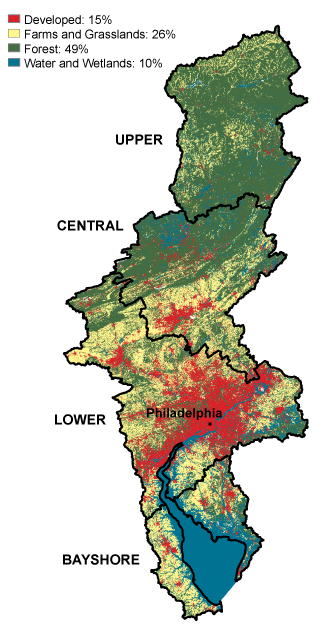
National Oceanic and Atmospheric Administration's (NOAA) Coastal Services Center (CSC) Basin Land Cover, 2006
Fast Facts
- Basin size: 13,500 square miles
- In-basin Population: 8.3 million (2010)
- Nearly 500,000 new people since 2000
- Projected: 9 million by 2030
- Every 1 million people adds ~100 million gallons daily to public water supply & wastewater treatment needs
- Development & people are concentrated in the Lower Basin Region (red on map)
- Forests (green on map) are important for water supply and quality and are still dominant in upper basin and most headwaters
- Freshwater and tidal wetlands (aqua on map) provide specialized habitat and flood protection
Did You Know? Forested land is being converted to other uses at a rate of 3,147 acres - or 2,400 football fields - a year!
♦ Learn more about the basin's population and landscape characteristics (pdf 8.15 MB; TREB Ch. 1)
♦ Learn more about the basin's aquatic habitats (pdf 16 MB; TREB Ch. 5)