Department of Environmental Protection

New Jersey Forest Service

NJDEP LogoNJ Forest Service Logo

Previous Next

Allen and Oswego Road Fire Mitigation and Habitat Restoration Project

Project Overview

On October 14, 2022, the New Jersey Pinelands Commission approved the New Jersey Forest Service and Forest Fire Service’s Allen and Oswego Road Fire Mitigation and Habitat Restoration Project in Bass River State Forest.

Project Purpose

Reduce the risk and severity of a wildfire.

In addition...
Protect the area from a southern pine bark beetle outbreaks.
Increase forest health.
Restore local wildlife habitat to historic conditions.

Project Work

Firebreak work will consist of removing vegetation and other flammable materials on a strip of land bordering the road to slow and hopefully stop the progress of forest fires. This cleared area will also provide access to fight any fires that may occur in the area. A similar strategic firebreak in Wharton State Forest helped limit the spread of the Penn Sawmp Fire in 2017 and the Mullica River Fire in 2022. The Mullica River Fire was the largest wildfire in New Jersey in over 15 years.

Forest thinning of 1,305 acres will remove highly flammable materials known as ladder fuels and improve wildlife habitat. Ladder fuels are small trees and low vegetation beneath the canopy. Most large trees will remain which will keep the canopy intact. Thinning allows for a healthier forest, reduces competition among trees and provides greater resource availability. Additionally, the likelihood of a catastrophic wildfire burning through a thinned forest is reduced. Following wildfires in 1977 and 1999, large portions of this area of Bass River State Forest have regenerated with high densities of trees resulting in ideal conditions for future wildfires. The current forest conditions put the forest and surrounding areas at an even higher risk of severe wildfire and southern pine beetle infestation. Due to the dangers associated with putting prescribed fire into this area currently, mechanical thinning must be implemented to mimic its effects. In the future, this forest and its less dense structure will be maintained with the use of prescribed fire.

Road maintenance work will improve conditions along 13 miles of Allen and Oswego Roads.

In a changing climate, this project will result in a healthier forest that is more resilient under various climate stressors and better able to capture and store carbon from the atmosphere.

Pinelands Commission Application

Pinelands Commission Application Download
Project Progress
Learn More

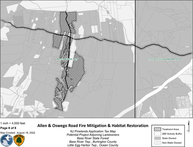
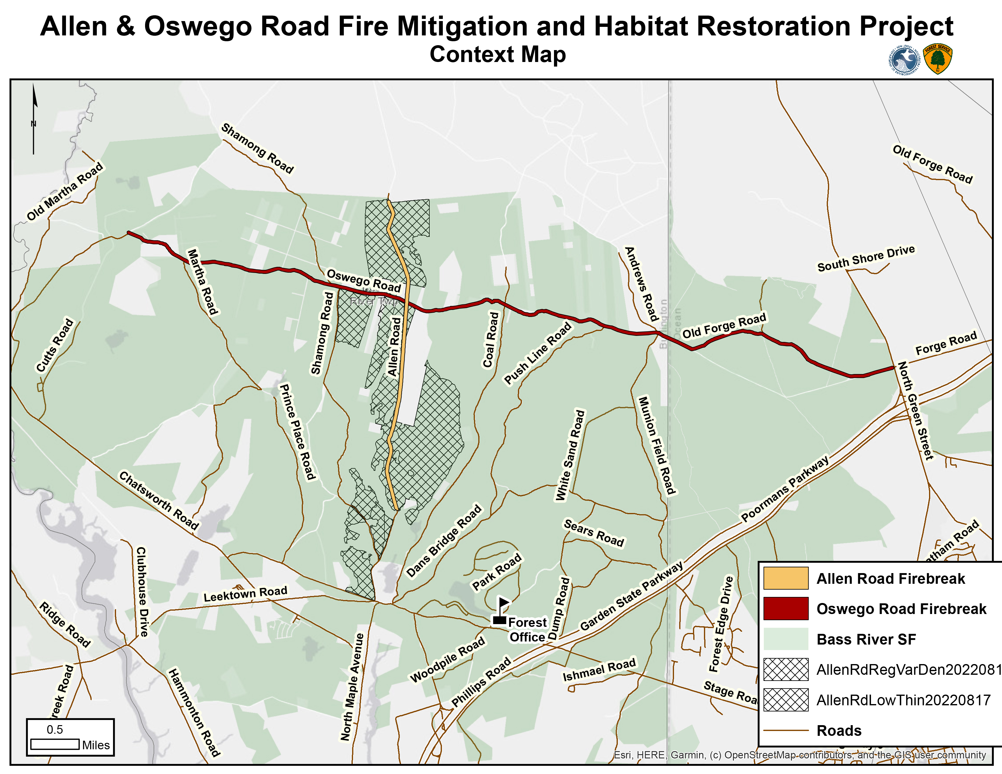
Current Conditions & Values At Risk

Current Conditions

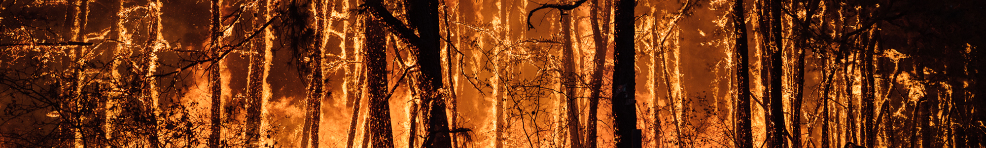
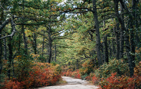
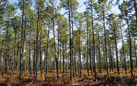
Current conditions along portions of the Allen Road and Oswego Road have regenerated with pitch pine trees at very high densities following the 1977 and 1999 wildfires that occurred in the area. Trees that are not adapted to grow at such densities expend much of their energy competing with neighboring trees for resources like water and sunlight. Due to the lack of resources and room to grow, these trees are not able to overcome this competition, are suppressed and often die as a result.

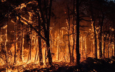
Whether the trees remain alive or not, these small, suppressed trees also act like a fuel ladder that can carry fire from the ground up to the treetops putting the forest at a high risk of a severe wildfire. Such dense and volatile conditions prevent New Jersey Forest Fire Service personnel from conducting prescribed burns that limit the risks of potential wildfires in the area because these conditions are unsafe for these operations. The lack of managed, prescribed burn treatments put the forest and surrounding areas at an even higher risk of severe wildfire. Other risks include that of southern pine beetle, one of the most destructive insect pests of pine trees. Outbreaks occur and flourish in dense forests, much like in the current conditions along Allen and Oswego Roads in Bass River State Forest. Areas with high tree densities have a large number of suppressed and weakened trees due to the competition for resources resulting in the trees in these areas being more susceptible to insect attacks. The higher the number of vulnerable pine trees the higher the number of beetles that will be attracted to the area causing an outbreak, and ultimately contributing to additional carbon loss.

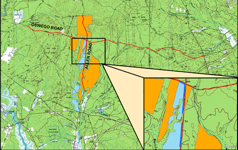
The New Jersey Forest Fire Service practices early detection and rapid response through a network of staffed fire towers and strategically positioned firefighting resources. If smoke is observed, Forest Fire Service personnel are deployed to investigate the cause of the smoke. However, current road conditions along Allen and Oswego Roads impede the rapid response time of on-the-ground personnel and resources.

Values at Risk: Life & Property

The values around Bass River State Forest – including homes, buildings, campgrounds, schools, infrastructure and businesses – are known as the wildland urban interface which are at risk of damage or destruction from a wildfire. To the east of the project area are the Garden State Parkway, Pinelands Regional High School, Bass River State Forest’s swimming area and campground, privately owned campgrounds and the Nugentown section of Little Egg Harbor Township. To the north and west of the project area are large scale cranberry farms, the Warren Grove Air to Ground Range and the Jenkins section of Washington Township. To the south, is the New Gretna section of Bass River Township.

Values at Risk: Natural Resources

Natural resources at risk include Atlantic white cedar restoration sites from the early 2000s and historic Atlantic white cedar populated wetlands that store significant amounts of carbon. These rich carbon stores could be released into the atmosphere if a wildfire impacts the cedar stand.

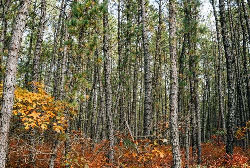
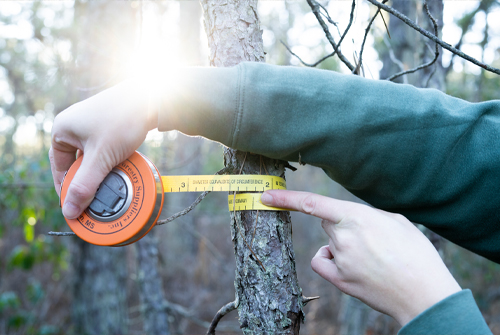
Current extreme density of trees seen off Allen Road.

Fire History

Bass River State Forest, and the New Jersey Pinelands region have a long history of wildfires. The Allen and Oswego Road Fire Mitigation and Habitat Restoration Project aims to break Bass River State Forest up into four geographic sections for fire management, allowing firefighters the best chance at halting a major wildfire before reaching communities and other values at risk.

The New Jersey Pinelands is a naturally fire-adapted forest ecosystem that depends on wildfire for reproduction and the control of fuel buildup. This forest community is one of the most hazardous forest fuel types in the nation, with fires burning extremely hot with the potential to spread rapidly via airborne burning embers landing up to a mile ahead of the main body of fire.

Many plant species in this area have adapted to fire and some are dependent on it for reproduction. Some tree and shrub species produce new sprouts after fire has killed or damaged the standing trunk, branches and leaves. The seeds of some plants are released when exposed to the heat generated by a fire and germinate readily on the relatively bare, sunny landscape that remains following fire. It is this dependence on fire that makes the Pinelands so unique, with many of the state’s listed threatened and endangered species thriving in the open conditions that had historically resulted from the natural fire regime.

Due to development, the natural fire regime of the area has been disrupted because wildfires are quickly suppressed to protect life and property. To maintain native pine barrens ecological communities and biodiversity, techniques including the use of prescribed fire and forest management practices to mimic the natural or historic disturbances are used throughout the region.

The Bass River Fires of 1977 and 1999 which are detailed to the right, are two of the most notable fires in the area of Allen and Oswego Roads. These fires primed the forest to regenerate with pitch pine at an excessive density, making this area of forest exceptionally susceptible to a large-scale wildfire. Additionally, in more recent history, the Dan's Bridge Fire (677 acres) on July 26, 2010, and the Henry Fire (460 acres) on May 12, 2016, were two wildfires that had potential for catastrophic consequences.

Bass River Fire of 1999

Date April 30, 1999
Acres Burned 11,813

Bass River Fire of 1977

Date July 22, 1977
Acres Burned 2,300

Firefighter Fatalities

During the Bass River Fire of 1977, the combination of drought conditions, a prolonged heat wave and a sudden and erratic wind shift resulted in the deaths of four firefighters from the Eagleswood Volunteer Fire Department. A case study of this incident was produced by the National Wildfire Coordinating Group.

On May 25, 1936, five firefighters from the Civilian Conservation Corps perished while fighting a fire in Bass River State Forest.

A memorial dedicated to the nine firefighters who lost their lives in the Bass River State Forest fires of 1936 and 1977 is located off E. Greenbush Road in Bass River State Forest.

Bass River State Forest Firefighter Memorial

What We Are Doing

Low & From Below Thinning

Through a forest management technique known as ‘low thinning’ or ‘low and from below thinning’ a lot of the flammable forest material (fuel) is removed by cutting the short, small diameter pine trees, slashing them and leaving them on the forest floor. As they decompose their nutrients will be added back into the soil to help the forest grow.

Low thinning reduces the chances of a catastrophic wildfire. Although wildfires can still occur, the rate at which a fire can reach from the ground to the treetops (the crowning index) is minimized. This slows the spread of a wildfire, allowing more time for emergency personnel to respond.

This type of thinning has many other benefits as well, such as providing greater resource availability for remaining trees, creating habitat more conducive for a variety of plant and wildlife species and significantly protecting the surrounding Atlantic white cedar stands.

The Allen and Oswego Road Fire Mitigation and Habitat Restoration Project includes 1,041-acres of low and from below thinning.

Variable Density Thinning

A forest that is thinned to a variable density results in an area with a large variety of tree species and sizes. This creates gaps in the forest of varying sizes, creating multiple layers, leaving behind woody debris, dead standing trees and large living trees. The combination of these characteristics increases biodiversity throughout the area.

The Allen and Oswego Road Fire Mitigation and Habitat Restoration Project has 255-acres of variable density thinning.

"Feathered" Variable Density Thinning

Feathered thinning will create a gradual transition of tree density along the edge of the road into the variable density thinning described above. This will reduce hard edges between the road edge and the thinned forest, creating a more visually appealing look.

The Allen and Oswego Road Fire Mitigation and Habitat Restoration Project has 8-acres of "feathered" variable density thinning.

Road Maintenance

Present day road conditions on Allen Road and Oswego Roads impedes access to the forest. Road maintenance activities could include the addition of gravel, removal/repair of existing broken hard surface material and road grading activities including crowning of the road surface.

The Allen and Oswego Road Fire Mitigation and Habitat Restoration Project will include 13 miles of road maintenance work along Allen Road and Oswego Road.

Firebreak Construction

Firebreak construction will consist of creating a strip of ground where vegetation will be removed to stop the progress of forest fires. This area will also provide access to fight any fires that may occur in the area. This will also allow the growth of native grasses to improve habitat conditions for a variety of wildlife species.

The fire break operation will consist of a 25-foot clearing on either side of Allen and Oswego Roads.

The Allen and Oswego Road Fire Mitigation and Habitat Restoration Project will include 78-acres of clearing for firebreak construction.

An example of the size of many of the trees that will be removed in the thinning activities.

Frequently Asked Questions

A: The New Jersey Department of Environmental Protection Forest Fire Service and Forest Service cooperativity developed the Allen and Oswego Road Fire Mitigation and Habitat Restoration project, the primary goal of which is to mitigate the risk of severe wildfire or southern pine bark beetle outbreak in an overly dense pine forest. The fire break operation proposal will include a 25-foot clearing on either side of the road.

Across the project, the goal is to stop the spread of fire by removing dense undergrowth and preventing fire from getting into the treetops where wind can intensify and rapidly spread fire. In addition to fire safety, this project also restores the forest to a more typical condition which is preferred by native plants and animals. Tree removal will focus on the smallest snow-bent pitch pine trees, and an intact canopy will be maintained across the site.

A: No, a number of environmental groups have reviewed and commented on the plan. Many concerns have been taken into consideration and the plans modified accordingly.

Read the Pinelands Preservation Alliance’s support for this project.

A: The area of forest proposed for this project has a long history of major wildfires, including the Bass River Fire of 1977 which killed four firefighters. The project area serves as an important corridor to control large wildfires before fire gets into complex wildland urban interfaces (places where structures and forests meet) to the east, which are more risky and dangerous places to control wildfire. Most recently, a wildfire in 1999 primed the area for regeneration of the current and tremendous tree density.

Historically, wind-driven wildfires in the Pine Barrens travel from west to east. There are human resources (homes, buildings, infrastructure) at risk to the east of the project area, including the Garden State Parkway, Bass River State Forest’s swimming area and campground, privately owned campgrounds and the Nugentown section of Little Egg Harbor Township. There are also natural resources at risk including regenerating Atlantic white cedar restoration sites from the early 2000s and historic Atlantic white cedar populated drainages, which store significant amounts of carbon.

A: Trees to be removed are selected based on their risk of spreading southern pine bark beetle and/or acting as ladder fuels (carrying fire from the ground to the forest canopy), and not for their commercial value. The trees in the project area are small, averaging less than two inches in diameter. It is not anticipated that any material of commercial value will be produced because of this project.

The majority of trees being cut will remain on site as they will likely be cut and mowed using a forestry mower. The mower will mow or chip up these small trees and leave the tree material on site to be cycled back into the soil. Due to the extreme density of trees within portions of the Allen and Oswego Road Fire Mitigation and Habitat Restoration Project some areas will need to be managed by hand. This will require personnel to go through on foot and manually complete the thinning. Further steps in the project will include conducting prescribed burns at these sites which will assist with nutrient cycling and help to maintain these areas in a more typical pinelands forest condition.

A: The Forest Service included the use of herbicide in the application to the Pinelands Commission in the event herbicide is needed to ensure the project’s success. Herbicide would be used to control plant regeneration, for managing invasive species. The Forest Service will only use herbicide if needed and only in specific spots within the site where invasive or competing vegetation threatens the project’s success and other methods of control are unsuccessful. It is hoped that herbicide use will not be necessary at all, but it is included in the approved application to protect against a potential worst-case scenario to be able to respond quickly and effectively to conditions impacting the success of the activity.

If herbicide treatment is necessary, the Forest Service will be using herbicides which are designed to not travel through soil and contaminate ground water. Herbicide would be applied by licensed pesticide applicators specifically trained in the use of herbicides and pesticides for forestry applications. Additionally, all herbicide use will occur according to the product’s label, adhering to the laws and strict standards set forth by the NJ Bureau of Pesticide Control.

A: The project area experienced a wildfire in 1999 that stimulated and allowed for regeneration of the current very high tree densities. The resulting forest density is approximately four times the average number of trees per acre occurring in the Pinelands today. Plot measurements of trees reveal that the average number of trees per acre in the Pinelands is roughly 500 trees per acre as of 2019. However, measurements in the section of Bass River State Forest proposed for thinning indicate that there are approximately 2,000 trees per acre.

A: The project will result in different tree densities, forest structures and habitat types that will offer protection, covering and a variety of foraging areas for different species.

A: Sensitive forest and wetland areas will be buffered from the thinning and firebreak management activities. No active management will take place in the buffer and the forest will remain dense and difficult to access, protecting these areas from illegal off-road vehicle use and damage.

A: Across the entire project area, over a period of years, it is possible that the total number of trees removed could be significant. However, the majority of those trees are young and very small (under 2” diameter). Many of the trees that will be removed can never reach full size due to the current stagnant conditions (extreme densities and lack of available resources like water and sunlight) in which they are growing.

BACKGROUND: The area of the project experienced a wildfire in 1999 that stimulated and allowed for regeneration of the current tremendous tree densities. The resulting forest density is approximately four times the average number of trees per acre occurring in the Pinelands today. Plot measurements of trees reveal that the average number of trees per acre in the Pinelands is roughly 500 trees per acre as of 2019. However, measurements in the section of Bass River State Forest proposed for thinning indicate that there are approximately 2,000 trees per acre.

Therefore, across the entire project area, over a period of years, it is possible that the total number of trees thinned could be significant. Simply looking at numbers of trees provides a dramatic perspective yet the number of trees to be removed is less important than the amount of growing space that these trees occupy. The selection of trees to be removed is a function of not only their number, but their size, position in the forest, and the risks they pose by being susceptible to bark beetles and their potential to carry wildfire from the ground to the forest canopy. Additionally, these are trees that haven’t realized and won’t achieve their growing potential due to the competition they face by growing alongside a high density of similarly sized trees, trees at formative stages (i.e., saplings or young stages of tree growth).

A: The area will be thinned in phases over a period of years based on the forest’s response to each treatment, allowing for some of the carbon lost through thinning to be re-captured by increased growth rates from the trees remaining on site. Trees to be thinned from the stand average less than two inches in diameter. Since the trees to be thinned from the site are smaller than the average for the stand, they contribute a comparatively small proportion of carbon to the overall stand, especially relative to the risks their excessive numbers pose from a bark beetle infestation or wildfire occurrence to both the area to be thinned and the adjacent forest.

Read more in the approved Pinelands Application for this project.

A: No, this is a forest thinning meaning most of the growth of the forest after the activity occurs in the trees that remain on the site, not from a new generation of trees. To learn more about the types of thinning being implemented in this project click here.

A: Southern pine beetle is one of the most destructive insect pests of pine trees. Outbreaks occur and flourish in dense forests, much like in the current conditions along Allen and Oswego Roads in Bass River State Forest. Once a susceptible host (often a stressed pine tree) is located, pine beetles release a pheromone attracting additional beetles. If enough beetles are attracted, the host tree is successfully colonized as well as adjacent pines. Attacking beetles bore into the bark and lay eggs and once hatched, larvae and adults move through the bark to feed and chew exit holes. Once reemerged, adults can fly and attack new trees.

Research shows, forest management through thinning is the preferred tool to increase tree health and vigor and reduce the likelihood of a southern pine bark beetle infestation and outbreak which would ultimately kill a large swath of forest.

A: The proposed activities are designed to avoid irreversible adverse impacts on habitats that are critical to the survival of any local populations of threatened and endangered animal species and irreversible adverse impacts on the survival of any local populations of threatened and endangered plant species.

To avoid potential irreversible adverse impacts on any threatened or endangered avian species that may be present, visual surveys will be conducted to identify and mark any trees containing potential threatened and endangered avian species cavities or nests. Any identified and marked trees will not be removed.

To avoid any irreversible adverse impacts on habitats that are critical to the survival of any local populations of threatened and endangered snake species, the forest management activities and the creation of the forest firebreak shall only occur between April 15 to November 15, the period when the concerned snake species are no longer hibernating.

To avoid potential irreversible adverse impacts on the survival of any local populations of Pine Barrens treefrog, a 100-foot buffer shall be maintained between the proposed forestry and proposed forest firebreak to potential Pine Barrens treefrog breeding habitat.

A: The approved New Jersey Pinelands Commission permit is valid for 10 years from the approval date of October 14, 2022. Therefore, any forest management, firebreak construction and road maintenance activity proposed in the approved application can occur within this 10-year period.

Forest management activities will occur in two phases, the first being at the beginning of the permit cycle and the second near the end of the permit cycle. After the thinnings take place at the beginning of the permit cycle, the forests will be continuously monitored and assessed. Towards the end of the permit cycle, if there are trees in the previously thinned areas that are beginning to show that they are more dominant than others, then a second thinning will occur in the same manner as the first.

A: Within the 10 years following the low and from below forest management activity, the forest will share some characteristics with its appearance today, however suppressed and smaller trees will have been removed allowing the residual trees to grow without significant wind damage and the canopy will have remained mostly intact with some small openings having slowly filled. Any slash or tree material left on the ground will have mostly decomposed or been burned providing nutrients to the residual trees. The treatment areas will have significantly less trees per acre, however trees will have increased in size and begun to show dominance, so much so that it will nearly be time for another low and from below thinning.

After 20 years from the time of the first thinning and 10 years from the time of the second thinning, all canopy trees will have improved in growth and vigor, in addition to resistance from disturbance agents like insects and disease.

In 40 years from now, significant growth will be apparent in the residual canopy trees which will have increased in size.

A:

Responsive image

Questions or Comments?

Email parks@dep.nj.gov.

Email Updates
To sign up for project updates, please enter your contact information below. Email updates will be provided as this webpage is updated.