Delaware • New Jersey • Pennsylvania
New York • United States of America
What is DRBC's River Mileage System?
The DRBC uses a stream location and identification system for the Delaware River and Bay based on river mileage.
The river mileage system was first published by our staff in 1969 and has been revised periodically since; it consists of a river mile zero and a mileage line along which distances from mile zero are measured.
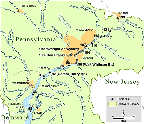 |
| An example of the River Mileage System. The river mile markers show the mileage, measured from the end of the Delaware Bay (river mile zero), north to the Delaware River's headwaters in New York State. |
River Mile Zero is located at the mouth of the Delaware Bay (i.e., where the bay meets the Atlantic Ocean) at the intersection of a line between the Cape May Light (New Jersey) and the tip of Cape Henlopen (Delaware) with the centerline of the navigation channel. The position of this point is Latitude 38° 50' 32" N and Longitude 75° 03' 18" W.
While mile zero is where the Delaware Bay meets the Atlantic Ocean, River Mile 330.7 is the beginning of the main stem Delaware River, where the East Branch of the Delaware meets the West Branch near the town of Hancock, New York.
The Mileage Line changes slightly depending on which part of the Delaware River you are referencing:
• From the mouth of the Delaware Bay to the Bridge Street Bridge in Trenton, N.J., the mileage line is the centerline of the main navigational channel.
• Between the Bridge Street Bridge in Trenton and Tristate Rock (near the mouth of the Neversink River, Port Jervis, N.Y.), river mileages are measured along the New Jersey-Pennsylvania boundary, which generally approximates the centerline of the Delaware River in this reach.
• Between Tristate Rock and the head of the main stem Delaware, the river mileages correspond to distances measured along the New York-Pennsylvania boundary.
Delaware River Mileage System (Archives)
• Download River Mileage System (PDF)
• Download River Mileage System (XLS; sort, filter and compute distances to upstream and downstream points)
• View River Mile Application for Google Earth (free Google Earth download initially required)