Delaware • New Jersey • Pennsylvania
New York • United States of America
- What is the SEPA-GWPA?
- Counties, Municipalities & Watersheds in the GWPA
- Archived Resources & Reports
- Percent of Groundwater Use in the Delaware River Basin: 1997-2017
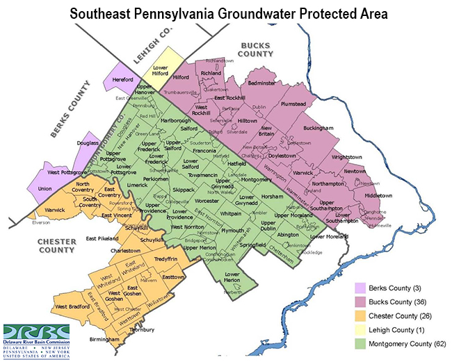
The Southeastern Pennsylvania Groundwater Protected Area (SEPA-GWPA or GWPA) is an area of southeastern Pennsylvania where more stringent regulations apply to groundwater withdrawals than they do in the rest of the Delaware River Basin.
It was initially established in 1980 by the DRBC at the request of the Commonwealth of Pennsylvania. That agreement remains in place today with DRBC maintaining primary responsibility to oversee the GWPA.
- Resolution 1980-18 (establishes the GWPA; archived PDF)
- Need a GWPA Permit? Click for GWPA Applicant Info
Why was the GWPA Created?
Increased development in this region was negatively impacting groundwater levels. Lowered water tables were reducing flows in some streams and drying up others.
This reduction in baseflows impacts downstream water uses, negatively affects aquatic life and can reduce the capacity of waterways in the region to assimilate pollutants.
GWPA Goals
- Prevent depletion of groundwater
- Protect interests and rights of all water users
- Balance and reconcile competing/conflicting uses of limited water resources
- Encourage water conservation
How Does it Work?
This program supports sustainable groundwater use through permitting, monitoring and conservation.
Resolution 1980-18 created the requirement that new or expanded well water projects located within the delineated GWPA involving an average withdrawal of more than 10,000 gallons per day (gpd) from a well or group of wells operated as a system must obtain a DRBC Protected Area Permit.
This is a stricter review threshold; in the remainder of the Delaware River Basin, DRBC's review threshold for water withdrawal projects is for an average withdrawal of more than 100,000 gpd during any calendar month.
In addition to lower-threshold permitting, GWPA management includes:
- Groundwater metering and reporting
- Conservation requirements
- Subbasin total withdrawal limits
- Additional mitigation in stressed subbasins, e.g. conjunctive use, artificial recharge
Is it Successful?
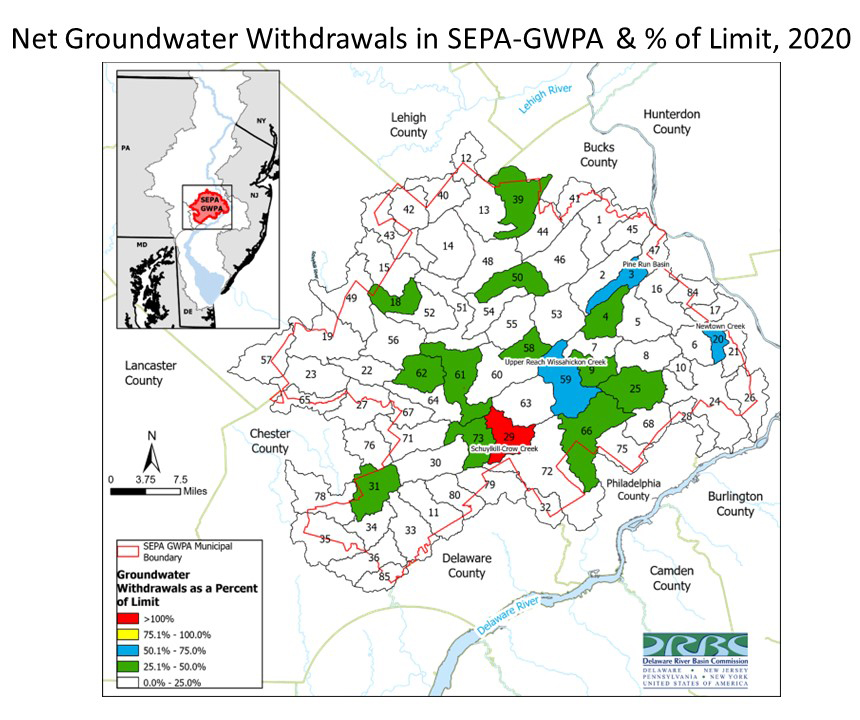
Yes, the GWPA regulatory program supports sustainable use of groundwater resources. Over the period from 2000 to 2020, cumulative net groundwater withdrawal in the GWPA has decreased.
Decreases are attributed to overall water conservation measures and to more surface water being used for water supply rather than ground water.
2022 Report
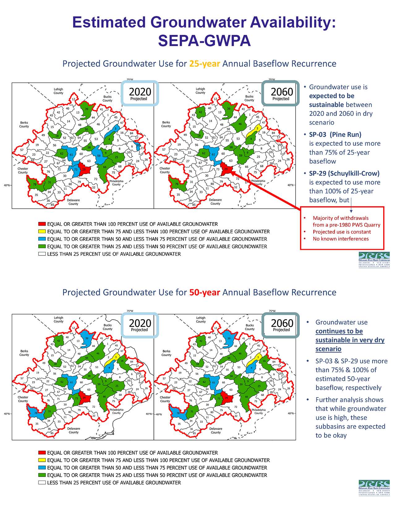
In December 2022, the DRBC published a report that analyzed DRB groundwater availability for the DRB and projected groundwater availability estimates through the year 2060. The report identified subbasins that are projected to approach or exceed withdrawal thresholds during a dry (25-year recurrence) and very dry (50-year recurrence; represents the drought of record). Analyses were completed at the DRB and GWPA scales.
- Estimated Groundwater Availability in the Delaware River Basin 2020 - 2060 (archived PDF; December 2022)
The report's key takeaway is that groundwater resources are being used at sustainable rates in the Delaware River Basin and also in the GWPA in both dry and very dry scenarios.
- Top level results for the GWPA are shown in the graphic below. Click to view larger.
- Looked at dry (25-year) and very dry (50-year) scenarios; results were similar
- Lack of color means that modeling showed those subwatersheds are projected to have less than 25% of available groundwater used, indicating sustainable use
- While use is projected to be higher in the colored subwatersheds, further analysis showed expected use to also be sustainable
- Looked at dry (25-year) and very dry (50-year) scenarios; results were similar
Looking Ahead
Future groundwater use will be impacted by climate change, seasonality and changes in water demands, reinforcing the need for continued management and planning. Staff will continue to evaluate water use against allocation and supply limits in the GWPA subbasins.
GWPA Basics
- Area: 1,200 square miles
- Population: One Million people
- Municipalities: 127
- Sub-basins: 76
- Water Uses: domestic; municipal; commercial; industrial and agricultural
Watersheds included in the GWPA
- Neshaminy Creek
- Brandywine Creek
- Perkiomen Creek
- Wissahickon Creek
Counties/Municipalities in the GWPA
- Montgomery County: entire
- Berks: the townships of Douglass, Hereford and Union
- Bucks: the townships of Bedminster, Buckingham, Doylestown, East Rockhill, Hilltown, Lower Southampton, Middletown, Milford, New Britain, Newtown, Northampton, Plumstead, Richland, Upper Southampton, Warminster, Warrington, Warwick, West Rockhill, and Wrightstown; the boroughs of Chalfont, Doylestown, Dublin, Hulmeville, Ivyland, Langhorne, Langhorne Manor, New Britain, Newtown, Penndel, Perkasie, Quakertown, Richlandtown, Sellersville, Silverdale, Telford and Trumbauersville
- Chester: the townships of Birmingham, Charlestown, East Bradford, East Coventry, East Goshen, East Pikeland, Easttown, East Vincent, East Whiteland, North Coventry, Schuylkill, South Coventry, Thornbury, Tredyffrin, Warwick, West Bradford, West Goshen, Westtown, Willistown and West Whiteland; the boroughs of Elverson, Malvern, Phoenixville, Spring City and West Chester
- Lehigh: Lower Milford Township
DRBC Reports
- Estimated Groundwater Availability in the Delaware River Basin 2020 - 2060 (includes GWPA; December 2022; PDF)
- Water Withdrawal & Consumptive Use Estimates (1990-2017) & Projections through 2060 (includes GWPA data; October 2021)
Related Resources
- Interactive Map of DRBC Docket & GWPA Permit Holders (can zoom in to see projects within the GWPA boundary)
- Real-time GWPA Well Data from USGS Observation Wells
- GIS Data Sets
- U.S. Geological Survey (USGS) Ground Water Data for Pennsylvania
- SEPA-GWPA Flyer (PDF)
- DRBC Case Study: Southeastern Pa. Groundwater Protected Area (PDF; 2019)
- SEPA-GWPA Total Subbasin Groundwater Withdrawals and % of Limit, 2020 (JPG)
This time series video shows the percent of groundwater use in the Delaware River Basin as compared to the available groundwater per hydrologic unit (watershed ID #) for the years 1997 - 2017. The Southeastern PA Groundwater Protected Area and NJ's Critical Area 2 are delineated; these are known areas of groundwater stress in the Basin. The time series was created by DRBC staff using data from USGS.