Governor Phil Murphy • Lt.Governor Sheila Oliver
NJ Home | Services A to Z | Departments/Agencies | FAQs  
State of New Jersey-Department of Environmental Protection-Air Quality, Energy and Sustainability
State of New Jersey Department of Environmental Protection
DEP Home | About DEP | Index by Topic | Programs/Units | DEP Online 


Spatial Analysis Research


The Bureau of Climate Change and Clean Energy uses advanced geographic information systems and remote sensing technology to perform spatial analysis research. This research supports the mission of NJDEP and the BPU’s Clean Energy Program. The Bureau presents findings through written reports and presentations at regional conferences.


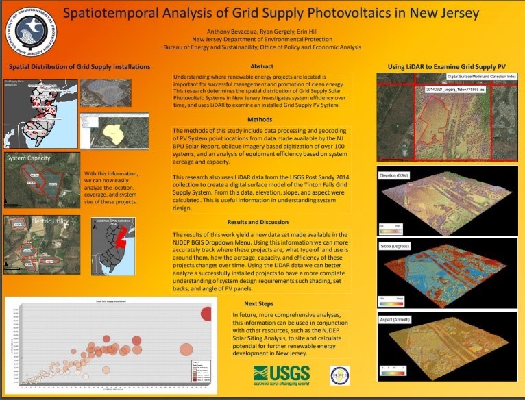
LiDAR & Solar PV Suitability: Atlantic City, New Jersey

The purpose of this work is to present alternative methods for siting solar photovoltaics. The current methods for most projects includes time consuming in situ measurements of available space, solar, and roof conditions. The research shown here highlights the potential for the use of sensing techniques that utilize Light Detection and Ranging (LiDAR), and Oblique Imagery to gain siting information remotely. When this data is available, assessment time and costs are reduced. This information can be used in project planning and design, as well as policy development.

MACURISA (Mid_Atlantic Chapter of the Urban and Regional Information Systems Association) in October 2018 Burlington County GIS day in November 2018. 


Growth of Residential Solar PV in New Jersey’s Municipalities

This map analyzes the growth of residential solar PV in New Jersey’s municipalities from 2000 to 2017 displaying the growth of solar in NJ and a breakdown of the top 10 municipalities by residential solar installed capacity. Presented at the Burlington County GIS day in November 2018. As a winning map in the 2018 NJDEP GIS Mapping contest it was sent to ESRI’s International User Conference in Sand Diego (July 9-13, 2018) and was on display in the Map Gallery.


NJDEP Solar Sitting Analysis Update (2017)

Analysis identifies and provides guidance on where the DEP encourages and discourages solar installations based on land use type; Designating the land as either “Preferred”, “Not-Preferred” or “Indeterminate”.
Presented at MACURISA (Mid_Atlantic Chapter of the Urban and Regional Information Systems Association) in October 2018.


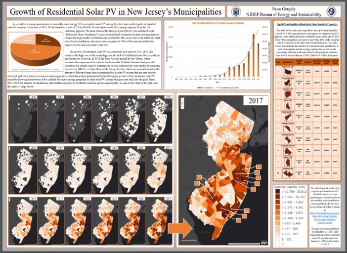
Spatiotemporal Analysis of Grid Supply Photovoltaics in New Jersey

Understanding where renewable energy projects are located is important for successful management and promotion of clean energy. This research determines the spatial distribution of Grid Supply Solar Photovoltaic Systems in New Jersey, investigates system efficiency over time, and uses LiDAR to examine an installed Grid Supply PV System. As a winning map in the 2018 NJDEP GIS Mapping contest it was sent to ESRI’s International User Conference in Sand Diego (July 9-13, 2018) and was on display in the Map Gallery.


AQES: Home
Department: NJDEP Home | About DEP | Index by Topic | Programs/Units | DEP Online
Statewide: NJ Home | Services A to Z | Departments/Agencies | FAQs

Copyright © State of New Jersey, 1996-2020

Last Updated: February 12, 2020