 Official Site of The State of New Jersey
Elevation
As part of New Jersey's statewide GIS coordination program, LiDAR data collections and derived elevation products are available for download. These data are stored in Amazon Web Services (AWS) Simple Storage Service through the AWS Open Data program and are available for download using the AWS Command Line Interface.
Quality Level 2 (QL2) collections provide the highest quality and most current elevation data available for New Jersey. Together, these regional collections cover the entire state.
Legacy collections provide a patchwork of older elevation data with varying quality specifications.
To see the spatial coverage of all elevation projects, use the now deprecated LiDAR and DEM Datasets for NJ index layer (previously used for the NJ Elevation Product Finder and Product Extent web applications).
These collections are no longer available on physical media such as hard drives. Contact Us for more information.
View details and download instructions for quality level 2 LiDAR collections and derived products in the sections below.
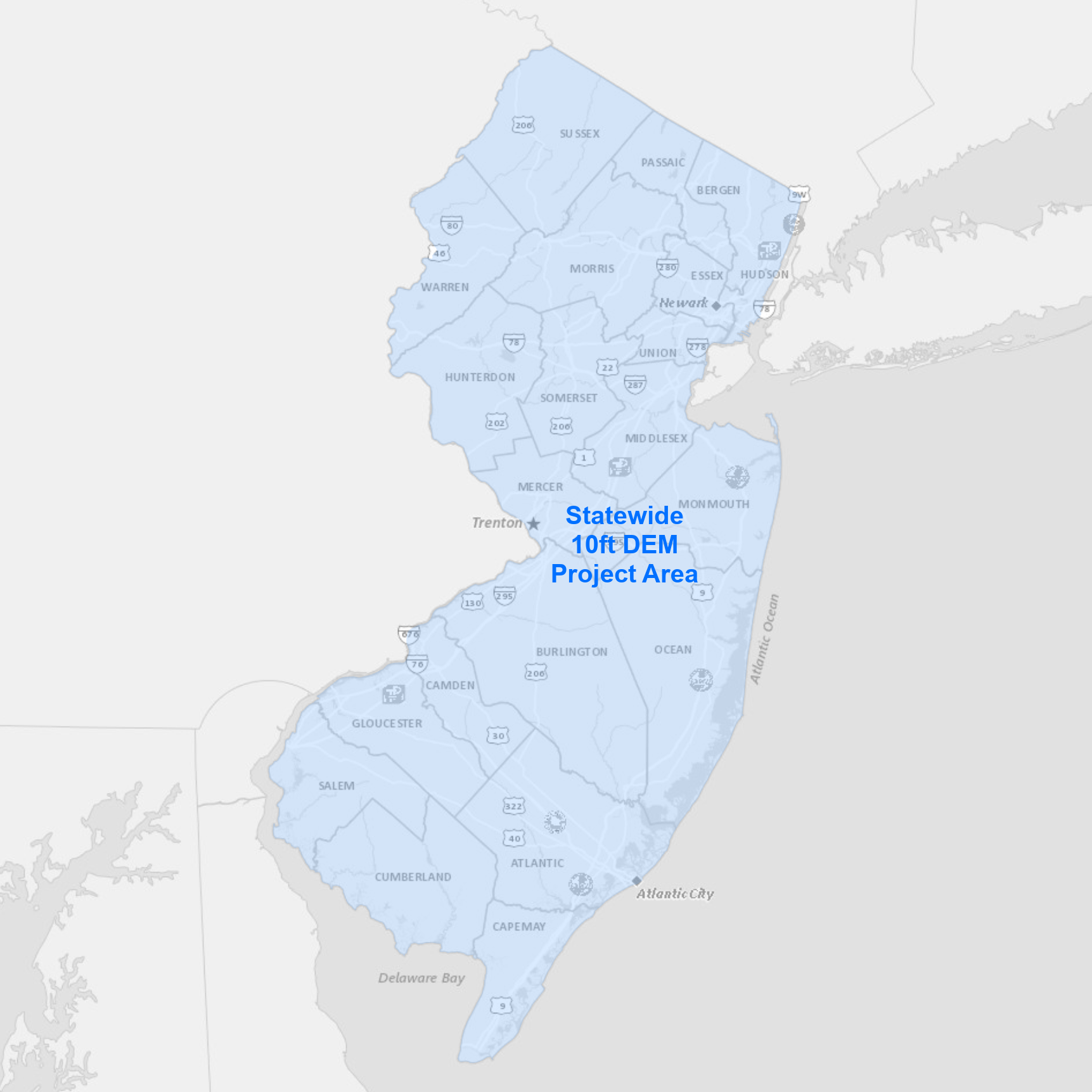 |
The DEM and hillshade cover the entire State of New Jersey. Image services available for streaming include: Data products available for download include:
|
Bulk download data products using the AWS Command Line Interface (CLI)
To download the files, use the AWS Command Line Interface. After installing the CLI, issue commands from your computer's command prompt. In Windows 10, that is found under "Windows System" or by right-clicking the Windows Start button, then click Run, then type cmd into the command line, then click OK. Instructions for download options are provided below:
- Download DEM files
- Download Hillshade files
- Download Aspect files
- Download Slope files
- Download all data products
Download DEM files
There are 12 files totaling 30.9 GB. Be sure there is adequate storage available on your computer. Once the CLI is installed, list all the files with the following command:
aws s3 ls s3://njogis-elevation/derived_products/statewide_2021/Statewide_10ft_DEM_2021/ --no-sign-request --human-readable
Perform a dry run without downloading any files to confirm the CLI is working and the command parameters are correct. Change the c:\DEM\ to the local directory into which the files will be copied. To execute a dry run, use the following command:
aws s3 cp s3://njogis-elevation/derived_products/statewide_2021/Statewide_10ft_DEM_2021/ c:\DEM\ --no-sign-request --recursive --dryrun
Upon a successful dry run, download the files to your computer using the following command (note the omission of the --dry-run parameter used above):
aws s3 cp s3://njogis-elevation/derived_products/statewide_2021/Statewide_10ft_DEM_2021/ c:\DEM\ --no-sign-request --recursive
The download command will run unattended until completion. It is likely to require several hours (or possibly days) depending on the speed of your internet connection and computer.
Download Hillshade files
There are 14 files totaling 6.5 GB. Be sure there is adequate storage available on your computer. Once the CLI is installed, list all the files with the following command:
aws s3 ls s3://njogis-elevation/derived_products/statewide_2021/Statewide_10ft_HSD_2021/ --no-sign-request --human-readable
Perform a dry run without downloading any files to confirm the CLI is working and the command parameters are correct. Change the c:\HSD\ to the local directory into which the files will be copied. To execute a dry run, use the following command:
aws s3 cp s3://njogis-elevation/derived_products/statewide_2021/Statewide_10ft_HSD_2021/ c:\HSD\ --no-sign-request --recursive --dryrun
Upon a successful dry run, download the files to your computer using the following command (note the omission of the --dry-run parameter used above):
aws s3 cp s3://njogis-elevation/derived_products/statewide_2021/Statewide_10ft_HSD_2021/ c:\HSD\ --no-sign-request --recursive
The download command will run unattended until completion. It is likely to require several hours (or possibly days) depending on the speed of your internet connection and computer.
Download Aspect files
There are 141 files totaling 11.1 GB. Be sure there is adequate storage available on your computer. Once the CLI is installed, list all the files with the following command:
aws s3 ls s3://njogis-elevation/derived_products/statewide_2021/Statewide_10ft_ASP_2021/ --no-sign-request --human-readable
Perform a dry run without downloading any files to confirm the CLI is working and the command parameters are correct. Change the c:\ASP\ to the local directory into which the files will be copied. To execute a dry run, use the following command:
aws s3 cp s3://njogis-elevation/derived_products/statewide_2021/Statewide_10ft_ASP_2021/ c:\ASP\ --no-sign-request --recursive --dryrun
Upon a successful dry run, download the files to your computer using the following command (note the omission of the --dry-run parameter used above):
aws s3 cp s3://njogis-elevation/derived_products/statewide_2021/Statewide_10ft_ASP_2021/ c:\ASP\ --no-sign-request --recursive
The download command will run unattended until completion. It is likely to require several hours (or possibly days) depending on the speed of your internet connection and computer.
Download Slope files
There are 158 files totaling 11.1 GB. Be sure there is adequate storage available on your computer. Once the CLI is installed, list all the files with the following command:
aws s3 ls s3://njogis-elevation/derived_products/statewide_2021/Statewide_10ft_SLP_2021/ --no-sign-request --human-readable
Perform a dry run without downloading any files to confirm the CLI is working and the command parameters are correct. Change the c:\SLP\ to the local directory into which the files will be copied. To execute a dry run, use the following command:
aws s3 cp s3://njogis-elevation/derived_products/statewide_2021/Statewide_10ft_SLP_2021/ c:\SLP\ --no-sign-request --recursive --dryrun
Upon a successful dry run, download the files to your computer using the following command (note the omission of the --dry-run parameter used above):
aws s3 cp s3://njogis-elevation/derived_products/statewide_2021/Statewide_10ft_SLP_2021/ c:\SLP\ --no-sign-request --recursive
The download command will run unattended until completion. It is likely to require several hours (or possibly days) depending on the speed of your internet connection and computer.
Download all data products
There are 326 files totaling 59.5 GB. Be sure there is adequate storage available on your computer. Once the CLI is installed, list all the files with the following command:
aws s3 ls s3://njogis-elevation/derived_products/statewide_2021/ --no-sign-request --human-readable
Perform a dry run without downloading any files to confirm the CLI is working and the command parameters are correct. Change the c:\NJ_elev\ to the local directory into which the files will be copied. To execute a dry run, use the following command:
aws s3 cp s3://njogis-elevation/derived_products/statewide_2021/ c:\NJ_elev\ --no-sign-request --recursive --dryrun
Upon a successful dry run, download the files to your computer using the following command (note the omission of the --dry-run parameter used above):
aws s3 cp s3://njogis-elevation/derived_products/statewide_2021/ c:\NJ_elev\ --no-sign-request --recursive
The download command will run unattended until completion. It is likely to require several hours (or possibly days) depending on the speed of your internet connection and computer.
 |
The collection area covers Atlantic, Cape May, Cumberland, Ocean and Salem Counties. Image services available for streaming include: Data products available for download include:
|
Download files using an interactive web app
South NJ 2019 LiDAR Project App
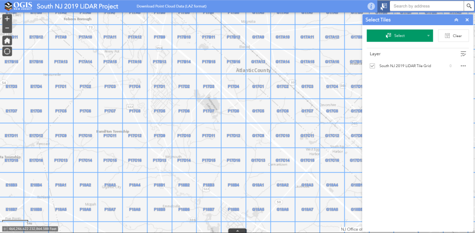
- User-friendly web application to download selected LiDAR files
- Download large numbers of files through unattended download
- Download by custom geography (view demo)
- Download using third-party bulk download utility, uGET
- View instructions from The National Map by USGS
- View demo
- View and download the South NJ 2019 LiDAR tile grid separately
- Access the same download-by-tile functionality as the South NJ 2019 LiDAR Project App using your own GIS software
Bulk download data products using the AWS Command Line Interface (CLI)
To download the files, use the AWS Command Line Interface. After installing the CLI, issue commands from your computer's command prompt. In Windows 10, that is found under "Windows System" or by right-clicking the Windows Start button, then click Run, then type cmd into the command line, then click OK. Instructions for download options are provided below:
Download compressed LAZ files
There are 3,077 LAZ files totaling 541.6 GB. Be sure there is adequate storage available on your computer. Once the CLI is installed, list all the LAZ files with the following command:
aws s3 ls s3://njogis-elevation/South_NJ_Lidar2019/SJ_NJDEP_data/LAZ/ --no-sign-request --human-readable
Perform a dry run without downloading any files to confirm the CLI is working and the command parameters are correct. Change the c:\LiDAR\ to the local directory into which the files will be copied. To execute a dry run, use the following command:
aws s3 cp s3://njogis-elevation/South_NJ_Lidar2019/SJ_NJDEP_data/LAZ/ c:\LiDAR\ --no-sign-request --recursive --dryrun
Upon a successful dry run, download the files to your computer using the following command (note the omission of the --dry-run parameter used above):
aws s3 cp s3://njogis-elevation/South_NJ_Lidar2019/SJ_NJDEP_data/LAZ/ c:\LiDAR\ --no-sign-request --recursive
The download command will run unattended until completion. It is likely to require several hours (or possibly days) depending on the speed of your internet connection and computer.
Download uncompressed LAS files
There are 3,078 LAS files totaling 2.2 TB. Be sure there is adequate storage available on your computer. Once the CLI is installed, list all the LAS files with the following command:
aws s3 ls s3://njogis-elevation/South_NJ_Lidar2019/point_cloud/tilecls/ --no-sign-request --human-readable
Perform a dry run without downloading any files to confirm the CLI is working and the command parameters are correct. Change the c:\LiDAR\ to the local directory into which the files will be copied. To execute a dry run, use the following command:
aws s3 cp s3://njogis-elevation/South_NJ_Lidar2019/point_cloud/tilecls/ c:\LiDAR\ --no-sign-request --recursive --dryrun
Upon a successful dry run, download the files to your computer using the following command (note the omission of the --dry-run parameter used above):
aws s3 cp s3://njogis-elevation/South_NJ_Lidar2019/point_cloud/tilecls/ c:\LiDAR\ --no-sign-request --recursive
The download command will run unattended until completion. It is likely to require several hours (or possibly days) depending on the speed of your internet connection and computer.
Download all data products
There are 31,008 files totaling 3.1 TB. Be sure there is adequate storage available on your computer. Once the CLI is installed, list all the files with the following command:
aws s3 ls s3://njogis-elevation/South_NJ_Lidar2019/ --no-sign-request --human-readable
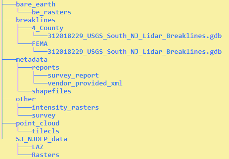
The directory structure is:
Perform a dry run without downloading any files to confirm the CLI is working and the command parameters are correct. Change the c:\LiDAR\ to the local directory into which the files will be copied. To execute a dry run, use the following command:
aws s3 cp s3://njogis-elevation/South_NJ_Lidar2019/ c:\LiDAR\ --no-sign-request --recursive --dryrun
Upon a successful dry run, download the files to your computer using the following command (note the omission of the --dry-run parameter used above):
aws s3 cp s3://njogis-elevation/South_NJ_Lidar2019/ c:\LiDAR\ --no-sign-request --recursive
The download command will run unattended until completion. It is likely to require several hours (or possibly days) depending on the speed of your internet connection and computer.
 |
The collection area covers Hunterdon, Morris, Passaic, Somerset, Sussex and Warren Counties. Image services available for streaming include: Data products available for download include:
|
Download files using an interactive web app
Northwest NJ 2018 LiDAR Project App
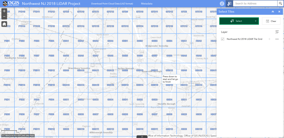
- User-friendly web application to download selected LiDAR files
- Download large numbers of files through unattended download
- Download by custom geography (view demo)
- Download using third-party bulk download utility, uGET
- View instructions from The National Map by USGS
- View demo
- View and download the Northwest NJ 2018 LiDAR tile grid separately
- Access the same download-by-tile functionality as the Northwest NJ 2018 LiDAR Project App using your own GIS software
Bulk download data products using the AWS Command Line Interface (CLI)
To download the files, use the AWS Command Line Interface. After installing the CLI, issue commands from your computer's command prompt. In Windows 10, that is found under "Windows System" or by right-clicking the Windows Start button, then click Run, then type cmd into the command line, then click OK. Instructions for download options are provided below:
Download compressed LAZ files
There are 2,843 files totaling 174.1 GB. Be sure there is adequate storage available on your computer. Once the CLI is installed, list all the files with the following command:
aws s3 ls s3://njogis-elevation/NorthwestNJ_2018/products_NJDEP/LAZ/ --no-sign-request --human-readable
Perform a dry run without downloading any files to confirm the CLI is working and the command parameters are correct. Change the c:\LiDAR\ to the local directory into which the files will be copied. To execute a dry run, use the following command:
aws s3 cp s3://njogis-elevation/NorthwestNJ_2018/products_NJDEP/LAZ/ c:\LiDAR\ --no-sign-request --recursive --dryrun
Upon a successful dry run, download the files to your computer using the following command (note the omission of the --dry-run parameter used above):
aws s3 cp s3://njogis-elevation/NorthwestNJ_2018/products_NJDEP/LAZ/ c:\LiDAR\ --no-sign-request --recursive
The download command will run unattended until completion. It is likely to require several hours (or possibly days) depending on the speed of your internet connection and computer.
Download uncompressed LAS files
There are 2,843 files totaling 840.9 GB. Be sure there is adequate storage available on your computer. Once the CLI is installed, list all the files with the following command:
aws s3 ls s3://njogis-elevation/NorthwestNJ_2018/point_cloud/tilecls/ --no-sign-request --human-readable
Perform a dry run without downloading any files to confirm the CLI is working and the command parameters are correct. Change the c:\LiDAR\ to the local directory into which the files will be copied. To execute a dry run, use the following command:
aws s3 cp s3://njogis-elevation/NorthwestNJ_2018/point_cloud/tilecls/ c:\LiDAR\ --no-sign-request --recursive --dryrun
Upon a successful dry run, download the files to your computer using the following command (note the omission of the --dry-run parameter used above):
aws s3 cp s3://njogis-elevation/NorthwestNJ_2018/point_cloud/tilecls/ c:\LiDAR\ --no-sign-request --recursive
The download command will run unattended until completion. It is likely to require several hours (or possibly days) depending on the speed of your internet connection and computer.
Download all data products
There are 34,234 project files totaling 1.3 TB. Be sure there is adequate storage available on your computer. Once the CLI is installed, list all the files with the following command:
aws s3 ls s3://njogis-elevation/NorthwestNJ_2018/ --no-sign-request --human-readable
Perform a dry run without downloading any files to confirm the CLI is working and the command parameters are correct. Change the c:\LiDAR\ to the local directory into which the files will be copied. To execute a dry run, use the following command:
aws s3 cp s3://njogis-elevation/NorthwestNJ_2018/ c:\LiDAR\ --no-sign-request --recursive --dryrun
Upon a successful dry run, download the files to your computer using the following command (note the omission of the --dry-run parameter used above):
aws s3 cp s3://njogis-elevation/NorthwestNJ_2018/ c:\LiDAR\ --no-sign-request --recursive
The download command will run unattended until completion. It is likely to require several hours (or possibly days) depending on the speed of your internet connection and computer.
 |
The collection areas covers coastal areas of the Atlantic Ocean and Delaware Bay. Data products available for download include:
View and download the Coastal NOAA Topobathy 2013/2014 LiDAR tile grid separately for download-by-tile functionality using your own GIS software. |
Bulk download data products using the AWS Command Line Interface (CLI)
To download the files, use the AWS Command Line Interface. After installing the CLI, issue commands from your computer's command prompt. In Windows 10, that is found under "Windows System" or by right-clicking the Windows Start button, then click Run, then type cmd into the command line, then click OK. Instructions for download options are provided below:
Download compressed LAZ files
There are 12,441 files totaling 378.3 GB. Be sure there is adequate storage available on your computer. Once the CLI is installed, list all the files with the following command:
aws s3 ls s3://njogis-elevation/CoastalNOAATopobathy_2013_2014_QL2/classified_laz/ --no-sign-request --human-readable
Perform a dry run without downloading any files to confirm the CLI is working and the command parameters are correct. Change the c:\LiDAR\ to the local directory into which the files will be copied. To execute a dry run, use the following command:
aws s3 cp s3://njogis-elevation/CoastalNOAATopobathy_2013_2014_QL2/classified_laz/ c:\LiDAR\ --no-sign-request --recursive --dryrun
Upon a successful dry run, download the files to your computer using the following command (note the omission of the --dry-run parameter used above):
aws s3 cp s3://njogis-elevation/CoastalNOAATopobathy_2013_2014_QL2/classified_laz/ c:\LiDAR\ --no-sign-request --recursive
The download command will run unattended until completion. It is likely to require several hours (or possibly days) depending on the speed of your internet connection and computer.
Download all data products
There are 12,572 project files totaling 402.1 GB. Be sure there is adequate storage available on your computer. Once the CLI is installed, list all the files with the following command:
aws s3 ls s3://njogis-elevation/CoastalNOAATopobathy_2013_2014_QL2/ --no-sign-request --human-readable
Perform a dry run without downloading any files to confirm the CLI is working and the command parameters are correct. Change the c:\LiDAR\ to the local directory into which the files will be copied. To execute a dry run, use the following command:
aws s3 cp s3://njogis-elevation/CoastalNOAATopobathy_2013_2014_QL2/ c:\LiDAR\ --no-sign-request --recursive --dryrun
Upon a successful dry run, download the files to your computer using the following command (note the omission of the --dry-run parameter used above):
aws s3 cp s3://njogis-elevation/CoastalNOAATopobathy_2013_2014_QL2/ c:\LiDAR\ --no-sign-request --recursive
The download command will run unattended until completion. It is likely to require several hours (or possibly days) depending on the speed of your internet connection and computer.
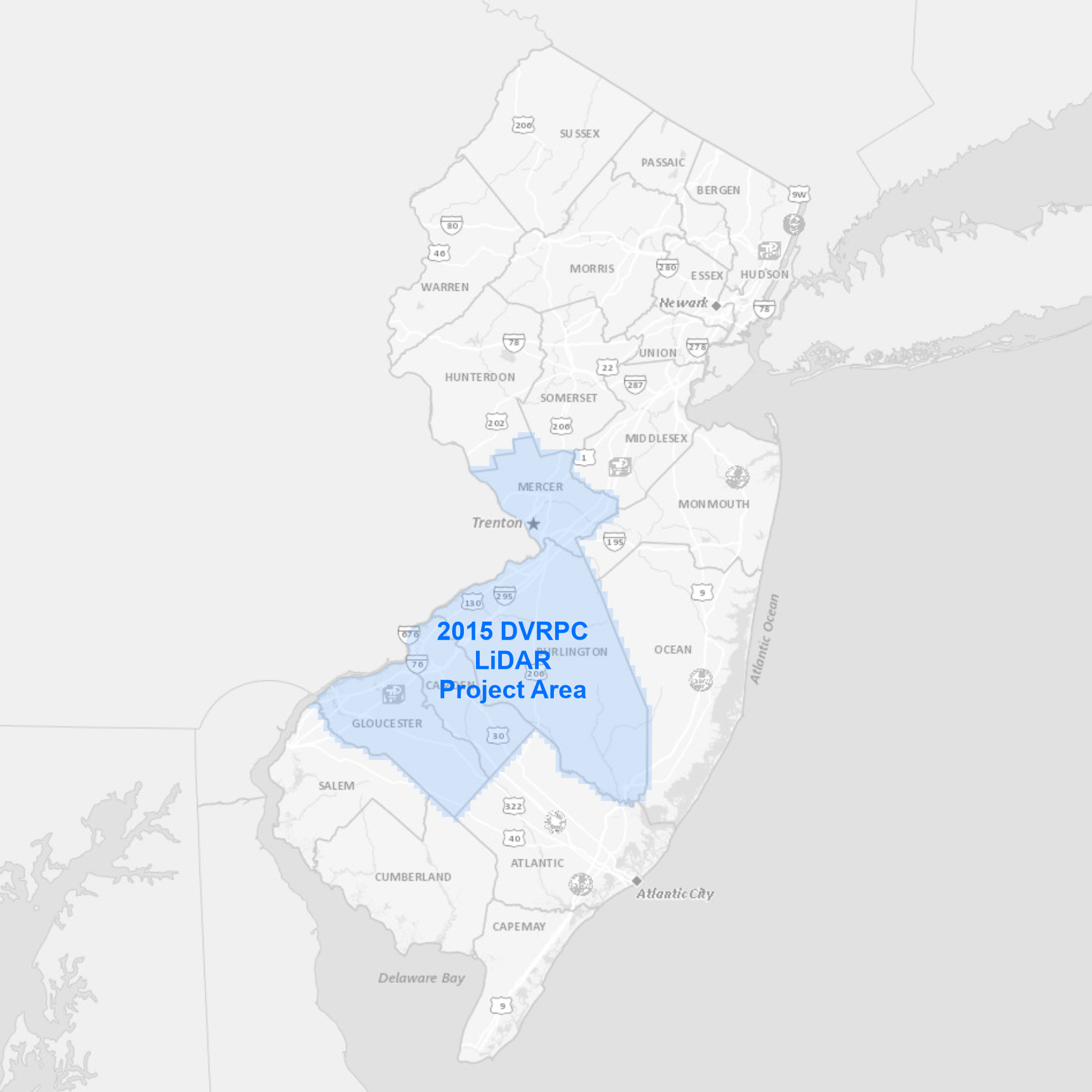 |
The collection area covers Burlington, Camden, Gloucester and Mercer Counties. Data products available for download include:
View and download the DVRPC 2015 LiDAR tile grid separately for download-by-tile functionality using your own GIS software. |
Bulk download data products using the AWS Command Line Interface (CLI)
To download the files, use the AWS Command Line Interface. After installing the CLI, issue commands from your computer's command prompt. In Windows 10, that is found under "Windows System" or by right-clicking the Windows Start button, then click Run, then type cmd into the command line, then click OK. Instructions for download options are provided below:
Download uncompressed LAS files
There are 3,585 files totaling 1.1 TB. Be sure there is adequate storage available on your computer. Once the CLI is installed, list all the files with the following command:
aws s3 ls s3://njogis-elevation/DVRPC_2015_QL2/Classified_LAS/ --no-sign-request --human-readable
Perform a dry run without downloading any files to confirm the CLI is working and the command parameters are correct. Change the c:\LiDAR\ to the local directory into which the files will be copied. To execute a dry run, use the following command:
aws s3 cp s3://njogis-elevation/DVRPC_2015_QL2/Classified_LAS/ c:\LiDAR\ --no-sign-request --recursive --dryrun
Upon a successful dry run, download the files to your computer using the following command (note the omission of the --dry-run parameter used above):
aws s3 cp s3://njogis-elevation/DVRPC_2015_QL2/Classified_LAS/ c:\LiDAR\ --no-sign-request --recursive
The download command will run unattended until completion. It is likely to require several hours (or possibly days) depending on the speed of your internet connection and computer.
Download all data products
There are 18,342 project files totaling 1.2 TB. Be sure there is adequate storage available on your computer. Once the CLI is installed, list all the files with the following command:
aws s3 ls s3://njogis-elevation/DVRPC_2015_QL2/ --no-sign-request --human-readable
Perform a dry run without downloading any files to confirm the CLI is working and the command parameters are correct. Change the c:\LiDAR\ to the local directory into which the files will be copied. To execute a dry run, use the following command:
aws s3 cp s3://njogis-elevation/DVRPC_2015_QL2/ c:\LiDAR\ --no-sign-request --recursive --dryrun
Upon a successful dry run, download the files to your computer using the following command (note the omission of the --dry-run parameter used above):
aws s3 cp s3://njogis-elevation/DVRPC_2015_QL2/ c:\LiDAR\ --no-sign-request --recursive
The download command will run unattended until completion. It is likely to require several hours (or possibly days) depending on the speed of your internet connection and computer.
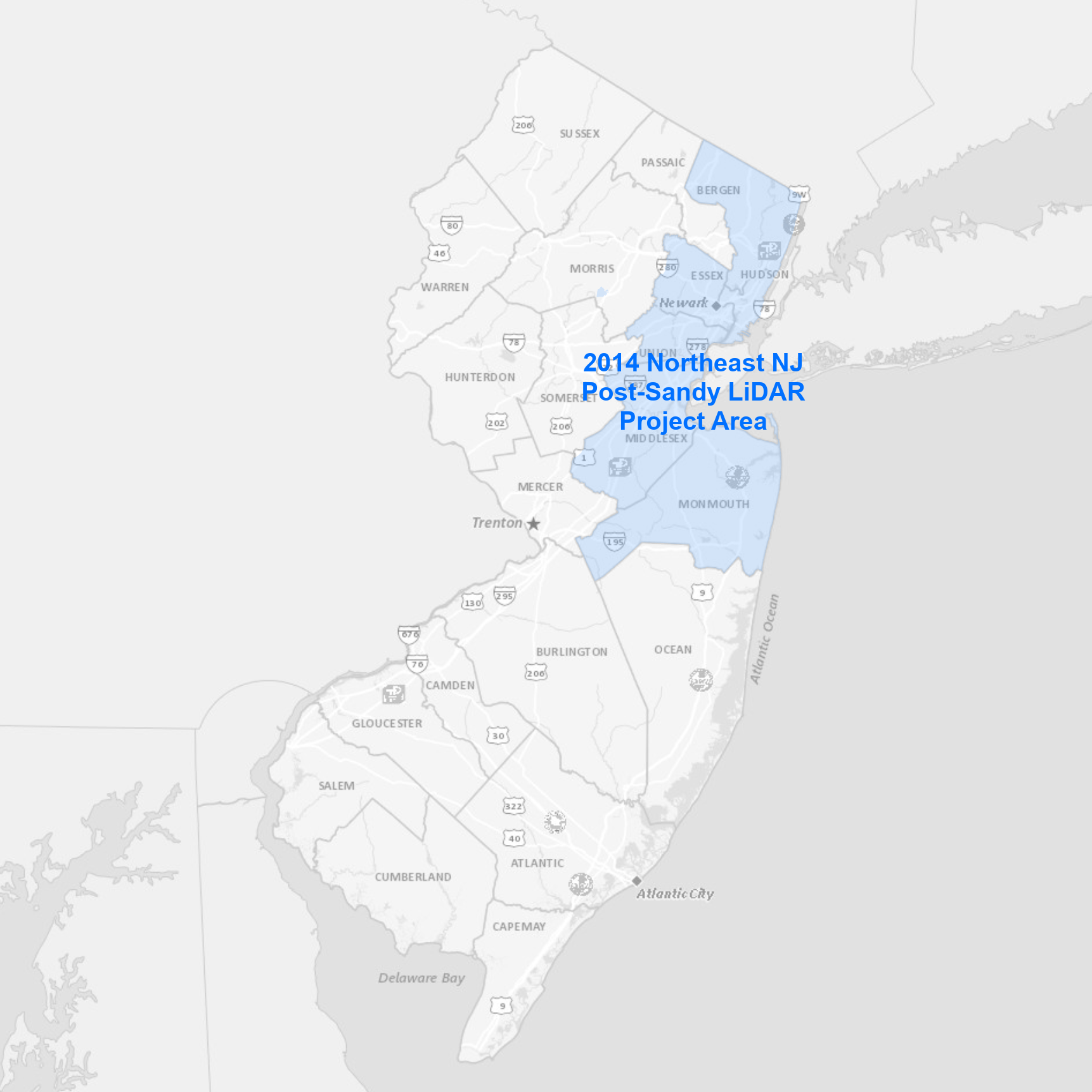 |
The collection area covers Bergen, Essex, Hudson, Middlesex, Monmouth and Union Counties. Data products available for download include:
View and download the Northeast NJ Post-Sandy 2014 LiDAR tile grid separately for download-by-tile functionality using your own GIS software. |
Bulk download data products using the AWS Command Line Interface (CLI)
To download the files, use the AWS Command Line Interface. After installing the CLI, issue commands from your computer's command prompt. In Windows 10, that is found under "Windows System" or by right-clicking the Windows Start button, then click Run, then type cmd into the command line, then click OK. Instructions for download options are provided below:
Download uncompressed LAS files
There are 1,782 files totaling 410.2 GB. Be sure there is adequate storage available on your computer. Once the CLI is installed, list all the files with the following command:
aws s3 ls s3://njogis-elevation/NortheastNJPostSandy_2014_QL2/LAS_1.2_Classified/ --no-sign-request --human-readable
Perform a dry run without downloading any files to confirm the CLI is working and the command parameters are correct. Change the c:\LiDAR\ to the local directory into which the files will be copied. To execute a dry run, use the following command:
aws s3 cp s3://njogis-elevation/NortheastNJPostSandy_2014_QL2/LAS_1.2_Classified/ c:\LiDAR\ --no-sign-request --recursive --dryrun
Upon a successful dry run, download the files to your computer using the following command (note the omission of the --dry-run parameter used above):
aws s3 cp s3://njogis-elevation/NortheastNJPostSandy_2014_QL2/LAS_1.2_Classified/ c:\LiDAR\ --no-sign-request --recursive
The download command will run unattended until completion. It is likely to require several hours (or possibly days) depending on the speed of your internet connection and computer.
Download all data products
There are 5,532 project files totaling 428.4 GB. Be sure there is adequate storage available on your computer. Once the CLI is installed, list all the files with the following command:
aws s3 ls s3://njogis-elevation/NortheastNJPostSandy_2014_QL2/ --no-sign-request --human-readable
Perform a dry run without downloading any files to confirm the CLI is working and the command parameters are correct. Change the c:\LiDAR\ to the local directory into which the files will be copied. To execute a dry run, use the following command:
aws s3 cp s3://njogis-elevation/NortheastNJPostSandy_2014_QL2/ c:\LiDAR\ --no-sign-request --recursive --dryrun
Upon a successful dry run, download the files to your computer using the following command (note the omission of the --dry-run parameter used above):
aws s3 cp s3://njogis-elevation/NortheastNJPostSandy_2014_QL2/ c:\LiDAR\ --no-sign-request --recursive
The download command will run unattended until completion. It is likely to require several hours (or possibly days) depending on the speed of your internet connection and computer.
View details and download instructions for legacy LiDAR collections and derived products in the sections below.
|
The DEM and hillshade cover the entire State of New Jersey. Image services available for streaming include: Data products available for download include:
|
Bulk download data products using the AWS Command Line Interface (CLI)
To download the files, use the AWS Command Line Interface. After installing the CLI, issue commands from your computer's command prompt. In Windows 10, that is found under "Windows System" or by right-clicking the Windows Start button, then click Run, then type cmd into the command line, then click OK. Instructions for download options are provided below:
Download all data products
Download DEM files
There are 74 files totaling 8.7 GB. Be sure there is adequate storage available on your computer. Once the CLI is installed, list all the files with the following command:
aws s3 ls s3://njogis-elevation/derived_products/statewide_2016/Statewide_10ft_DEM_2016/ --no-sign-request --human-readable
Perform a dry run without downloading any files to confirm the CLI is working and the command parameters are correct. Change the c:\DEM\ to the local directory into which the files will be copied. To execute a dry run, use the following command:
aws s3 cp s3://njogis-elevation/derived_products/statewide_2016/Statewide_10ft_DEM_2016/ c:\DEM\ --no-sign-request --recursive --dryrun
Upon a successful dry run, download the files to your computer using the following command (note the omission of the --dry-run parameter used above):
aws s3 cp s3://njogis-elevation/derived_products/statewide_2016/Statewide_10ft_DEM_2016/ c:\DEM\ --no-sign-request --recursive
The download command will run unattended until completion. It is likely to require several hours (or possibly days) depending on the speed of your internet connection and computer.
Download Hillshade files
There are 74 files totaling 1.6 GB. Be sure there is adequate storage available on your computer. Once the CLI is installed, list all the files with the following command:
aws s3 ls s3://njogis-elevation/derived_products/statewide_2016/Statewide_10ft_HSD_2016/ --no-sign-request --human-readable
Perform a dry run without downloading any files to confirm the CLI is working and the command parameters are correct. Change the c:\HSD\ to the local directory into which the files will be copied. To execute a dry run, use the following command:
aws s3 cp s3://njogis-elevation/derived_products/statewide_2016/Statewide_10ft_HSD_2016/ c:\HSD\ --no-sign-request --recursive --dryrun
Upon a successful dry run, download the files to your computer using the following command (note the omission of the --dry-run parameter used above):
aws s3 cp s3://njogis-elevation/derived_products/statewide_2016/Statewide_10ft_HSD_2016/ c:\HSD\ --no-sign-request --recursive
The download command will run unattended until completion. It is likely to require several hours (or possibly days) depending on the speed of your internet connection and computer.
Download all data products
There are 149 files totaling 10.2 GB. Be sure there is adequate storage available on your computer. Once the CLI is installed, list all the files with the following command:
aws s3 ls s3://njogis-elevation/derived_products/statewide_2016/ --no-sign-request --human-readable
Perform a dry run without downloading any files to confirm the CLI is working and the command parameters are correct. Change the c:\DEM_HSD\ to the local directory into which the files will be copied. To execute a dry run, use the following command:
aws s3 cp s3://njogis-elevation/derived_products/statewide_2016/ c:\DEM_HSD\ --no-sign-request --recursive --dryrun
Upon a successful dry run, download the files to your computer using the following command (note the omission of the --dry-run parameter used above):
aws s3 cp s3://njogis-elevation/derived_products/statewide_2016/ c:\DEM_HSD\ --no-sign-request --recursive
The download command will run unattended until completion. It is likely to require several hours (or possibly days) depending on the speed of your internet connection and computer.
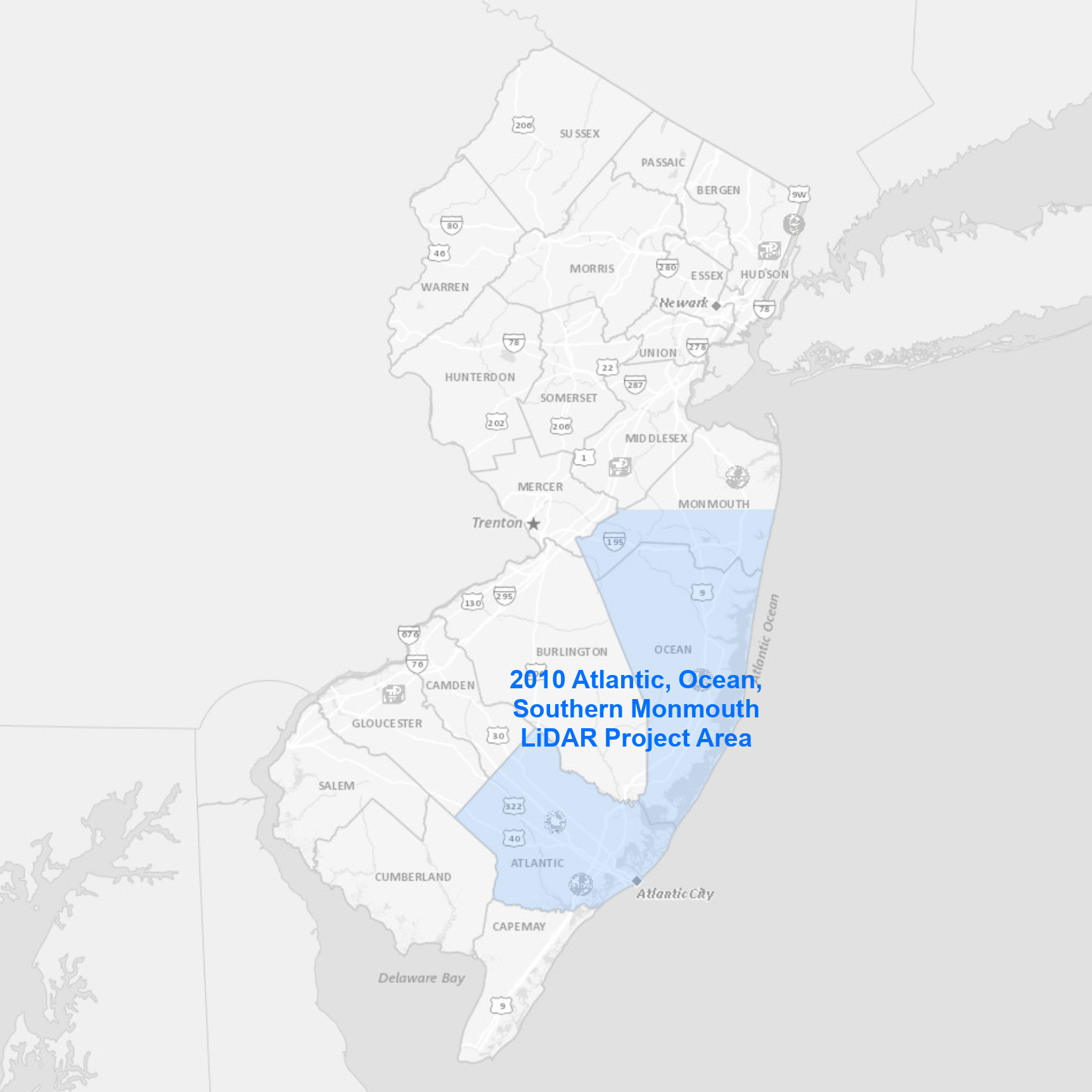 |
The collection area covers Atlantic, southern Monmouth, and Ocean Counties. Data products available for download include:
|
Bulk download data products using the AWS Command Line Interface (CLI)
To download the files, use the AWS Command Line Interface. After installing the CLI, issue commands from your computer's command prompt. In Windows 10, that is found under "Windows System" or by right-clicking the Windows Start button, then click Run, then type cmd into the command line, then click OK. Instructions for download options are provided below:
Download uncompressed LAS files
There are 1,974 files totaling 227.5 GB. Be sure there is adequate storage available on your computer. Once the CLI is installed, list all the files with the following command:
aws s3 ls s3://njogis-elevation/QL3/AtlanticOceanSouthernMonmouth_2010/Points/Classified/ --no-sign-request --human-readable
Perform a dry run without downloading any files to confirm the CLI is working and the command parameters are correct. Change the c:\LiDAR\ to the local directory into which the files will be copied. To execute a dry run, use the following command:
aws s3 cp s3://njogis-elevation/QL3/AtlanticOceanSouthernMonmouth_2010/Points/Classified/ c:\LiDAR\ --no-sign-request --recursive --dryrun
Upon a successful dry run, download the files to your computer using the following command (note the omission of the --dry-run parameter used above):
aws s3 cp s3://njogis-elevation/QL3/AtlanticOceanSouthernMonmouth_2010/Points/Classified/ c:\LiDAR\ --no-sign-request --recursive
The download command will run unattended until completion. It is likely to require several hours (or possibly days) depending on the speed of your internet connection and computer.
Download all data products
There are 18,029 project files totaling 274.5 GB. Be sure there is adequate storage available on your computer. Once the CLI is installed, list all the files with the following command:
aws s3 ls s3://njogis-elevation/QL3/AtlanticOceanSouthernMonmouth_2010/ --no-sign-request --human-readable
Perform a dry run without downloading any files to confirm the CLI is working and the command parameters are correct. Change the c:\LiDAR\ to the local directory into which the files will be copied. To execute a dry run, use the following command:
aws s3 cp s3://njogis-elevation/QL3/AtlanticOceanSouthernMonmouth_2010/ c:\LiDAR\ --no-sign-request --recursive --dryrun
Upon a successful dry run, download the files to your computer using the following command (note the omission of the --dry-run parameter used above):
aws s3 cp s3://njogis-elevation/QL3/AtlanticOceanSouthernMonmouth_2010/ c:\LiDAR\ --no-sign-request --recursive
The download command will run unattended until completion. It is likely to require several hours (or possibly days) depending on the speed of your internet connection and computer.
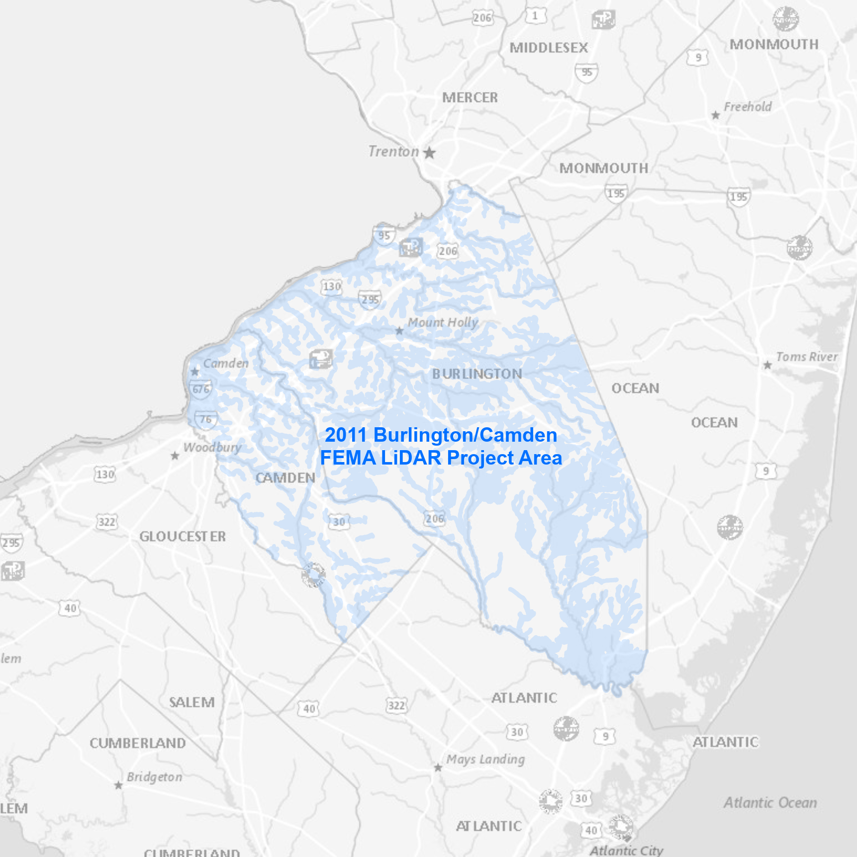 |
The collection area covers river and stream corridors in Burlington and Camden Counties. Data products available for download include:
|
Bulk download data products using the AWS Command Line Interface (CLI)
To download the files, use the AWS Command Line Interface. After installing the CLI, issue commands from your computer's command prompt. In Windows 10, that is found under "Windows System" or by right-clicking the Windows Start button, then click Run, then type cmd into the command line, then click OK. Instructions for download options are provided below:
Download uncompressed LAS files
There are 1,234 files totaling 69.1 GB. Be sure there is adequate storage available on your computer. Once the CLI is installed, list all the files with the following command:
aws s3 ls s3://njogis-elevation/QL3/BurlCam2011FEMApointcloud/Points/Gridded_Tiles-Las-classified/ --no-sign-request --human-readable
Perform a dry run without downloading any files to confirm the CLI is working and the command parameters are correct. Change the c:\LiDAR\ to the local directory into which the files will be copied. To execute a dry run, use the following command:
aws s3 cp s3://njogis-elevation/QL3/BurlCam2011FEMApointcloud/Points/Gridded_Tiles-Las-classified/ c:\LiDAR\ --no-sign-request --recursive --dryrun
Upon a successful dry run, download the files to your computer using the following command (note the omission of the --dry-run parameter used above):
aws s3 cp s3://njogis-elevation/QL3/BurlCam2011FEMApointcloud/Points/Gridded_Tiles-Las-classified/ c:\LiDAR\ --no-sign-request --recursive
The download command will run unattended until completion. It is likely to require several hours (or possibly days) depending on the speed of your internet connection and computer.
Download all data products
There are 1,547 project files totaling 228.6 GB. Be sure there is adequate storage available on your computer. Once the CLI is installed, list all the files with the following command:
aws s3 ls s3://njogis-elevation/QL3/BurlCam2011FEMApointcloud/ --no-sign-request --human-readable
Perform a dry run without downloading any files to confirm the CLI is working and the command parameters are correct. Change the c:\LiDAR\ to the local directory into which the files will be copied. To execute a dry run, use the following command:
aws s3 cp s3://njogis-elevation/QL3/BurlCam2011FEMApointcloud/ c:\LiDAR\ --no-sign-request --recursive --dryrun
Upon a successful dry run, download the files to your computer using the following command (note the omission of the --dry-run parameter used above):
aws s3 cp s3://njogis-elevation/QL3/BurlCam2011FEMApointcloud/ c:\LiDAR\ --no-sign-request --recursive
The download command will run unattended until completion. It is likely to require several hours (or possibly days) depending on the speed of your internet connection and computer.
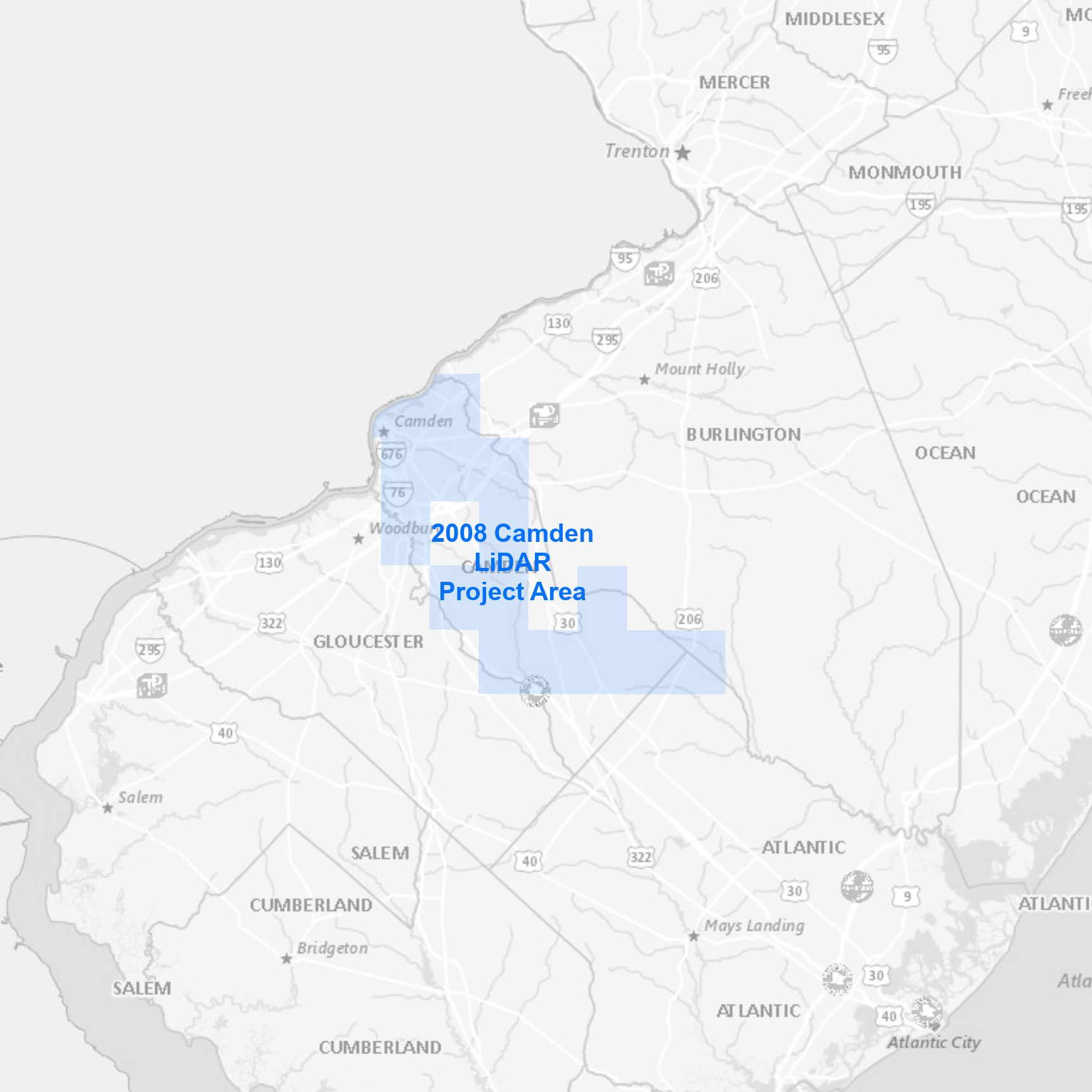 |
The collection area covers select areas in Camden County. Data products available for download include:
|
Bulk download data products using the AWS Command Line Interface (CLI)
To download the files, use the AWS Command Line Interface. After installing the CLI, issue commands from your computer's command prompt. In Windows 10, that is found under "Windows System" or by right-clicking the Windows Start button, then click Run, then type cmd into the command line, then click OK. Instructions for download options are provided below:
Download uncompressed unclassified LAS files
There are 52 files totaling 13.6 GB. Be sure there is adequate storage available on your computer. Once the CLI is installed, list all the files with the following command:
aws s3 ls s3://njogis-elevation/QL3/Camden_2008/Consultant/camden_las/ --no-sign-request --human-readable
Perform a dry run without downloading any files to confirm the CLI is working and the command parameters are correct. Change the c:\LiDAR\ to the local directory into which the files will be copied. To execute a dry run, use the following command:
aws s3 cp s3://njogis-elevation/QL3/Camden_2008/Consultant/camden_las/ c:\LiDAR\ --no-sign-request --recursive --dryrun
Upon a successful dry run, download the files to your computer using the following command (note the omission of the --dry-run parameter used above):
aws s3 cp s3://njogis-elevation/QL3/Camden_2008/Consultant/camden_las/ c:\LiDAR\ --no-sign-request --recursive
The download command will run unattended until completion. It is likely to require several hours (or possibly days) depending on the speed of your internet connection and computer.
Download all data products
There are 102 project files totaling 14.3 GB. Be sure there is adequate storage available on your computer. Once the CLI is installed, list all the files with the following command:
aws s3 ls s3://njogis-elevation/QL3/Camden_2008/ --no-sign-request --human-readable
Perform a dry run without downloading any files to confirm the CLI is working and the command parameters are correct. Change the c:\LiDAR\ to the local directory into which the files will be copied. To execute a dry run, use the following command:
aws s3 cp s3://njogis-elevation/QL3/Camden_2008/ c:\LiDAR\ --no-sign-request --recursive --dryrun
Upon a successful dry run, download the files to your computer using the following command (note the omission of the --dry-run parameter used above):
aws s3 cp s3://njogis-elevation/QL3/Camden_2008/ c:\LiDAR\ --no-sign-request --recursive
The download command will run unattended until completion. It is likely to require several hours (or possibly days) depending on the speed of your internet connection and computer.
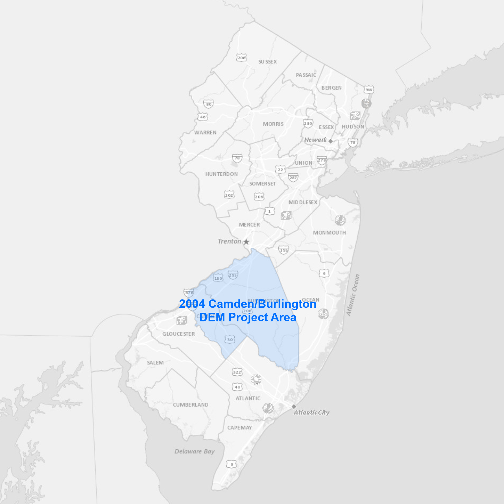 |
The project area covers Burlington and Camden Counties. Data products available for download include:
|
Bulk download data products using the AWS Command Line Interface (CLI)
To download the files, use the AWS Command Line Interface. After installing the CLI, issue commands from your computer's command prompt. In Windows 10, that is found under "Windows System" or by right-clicking the Windows Start button, then click Run, then type cmd into the command line, then click OK. Instructions for download options are provided below:
Download all data products
There are 44 project files totaling 3.5 GB. Be sure there is adequate storage available on your computer. Once the CLI is installed, list all the files with the following command:
aws s3 ls s3://njogis-elevation/derived_products/Camden_Burlington_DEM_2004/ --no-sign-request --human-readable
Perform a dry run without downloading any files to confirm the CLI is working and the command parameters are correct. Change the c:\DEM\ to the local directory into which the files will be copied. To execute a dry run, use the following command:
aws s3 cp s3://njogis-elevation/derived_products/Camden_Burlington_DEM_2004/ c:\DEM\ --no-sign-request --recursive --dryrun
Upon a successful dry run, download the files to your computer using the following command (note the omission of the --dry-run parameter used above):
aws s3 cp s3://njogis-elevation/derived_products/Camden_Burlington_DEM_2004/ c:\DEM\ --no-sign-request --recursive
The download command will run unattended until completion. It is likely to require several hours (or possibly days) depending on the speed of your internet connection and computer.
 |
The collection area covers Cape May, Cumberland and CAFRA Salem Counties. Data products available for download include:
|
Bulk download data products using the AWS Command Line Interface (CLI)
To download the files, use the AWS Command Line Interface. After installing the CLI, issue commands from your computer's command prompt. In Windows 10, that is found under "Windows System" or by right-clicking the Windows Start button, then click Run, then type cmd into the command line, then click OK. Instructions for download options are provided below:
Download uncompressed classified LAS files
There are 2,487 files totaling 224.6 GB. Be sure there is adequate storage available on your computer. Once the CLI is installed, list all the files with the following command:
aws s3 ls "s3://njogis-elevation/QL3/CapeMayCumberlandCAFRA Salem_2008/Points/" --no-sign-request --human-readable
Perform a dry run without downloading any files to confirm the CLI is working and the command parameters are correct. Change the c:\LiDAR\ to the local directory into which the files will be copied. To execute a dry run, use the following command:
aws s3 cp "s3://njogis-elevation/QL3/CapeMayCumberlandCAFRA Salem_2008/Points/" c:\LiDAR\ --no-sign-request --recursive --dryrun
Upon a successful dry run, download the files to your computer using the following command (note the omission of the --dry-run parameter used above):
aws s3 cp "s3://njogis-elevation/QL3/CapeMayCumberlandCAFRA Salem_2008/Points/" c:\LiDAR\ --no-sign-request --recursive
The download command will run unattended until completion. It is likely to require several hours (or possibly days) depending on the speed of your internet connection and computer.
Download all data products
There are 29,989 project files totaling 260.7 GB. Be sure there is adequate storage available on your computer. Once the CLI is installed, list all the files with the following command:
aws s3 ls "s3://njogis-elevation/QL3/CapeMayCumberlandCAFRA Salem_2008/" --no-sign-request --human-readable
Perform a dry run without downloading any files to confirm the CLI is working and the command parameters are correct. Change the c:\LiDAR\ to the local directory into which the files will be copied. To execute a dry run, use the following command:
aws s3 cp "s3://njogis-elevation/QL3/CapeMayCumberlandCAFRA Salem_2008/" c:\LiDAR\ --no-sign-request --recursive --dryrun
Upon a successful dry run, download the files to your computer using the following command (note the omission of the --dry-run parameter used above):
aws s3 cp "s3://njogis-elevation/QL3/CapeMayCumberlandCAFRA Salem_2008/" c:\LiDAR\ --no-sign-request --recursive
The download command will run unattended until completion. It is likely to require several hours (or possibly days) depending on the speed of your internet connection and computer.
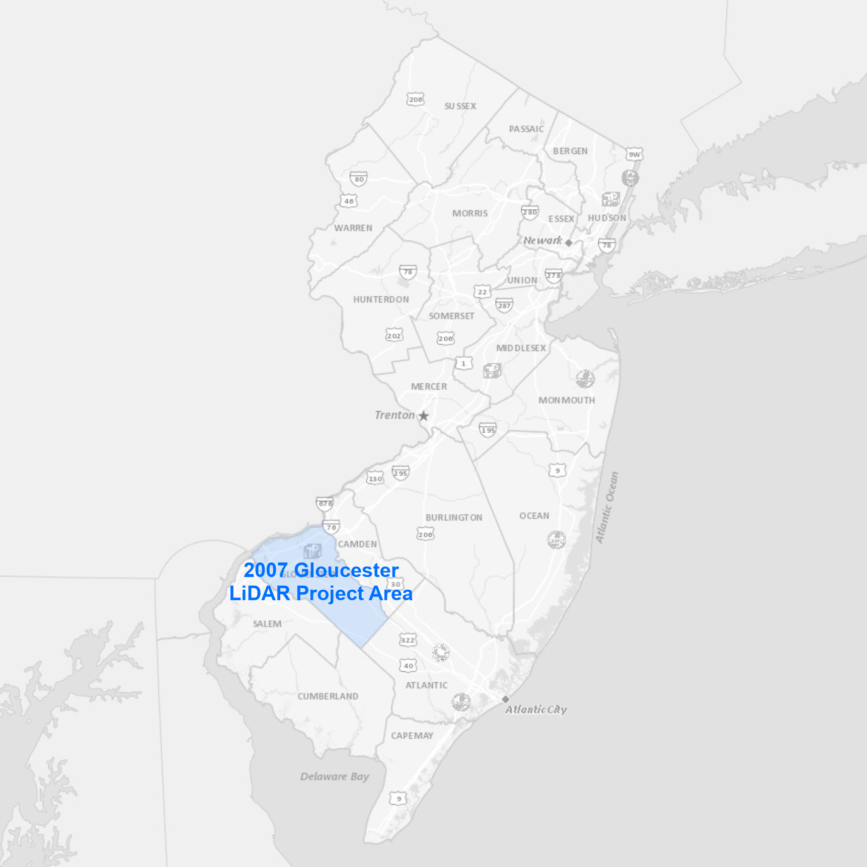 |
The collection area covers Gloucester County. Data products available for download include:
|
Bulk download data products using the AWS Command Line Interface (CLI)
To download the files, use the AWS Command Line Interface. After installing the CLI, issue commands from your computer's command prompt. In Windows 10, that is found under "Windows System" or by right-clicking the Windows Start button, then click Run, then type cmd into the command line, then click OK. Instructions for download options are provided below:
Download uncompressed LAS files
There are 441 files totaling 39.7 GB. Be sure there is adequate storage available on your computer. Once the CLI is installed, list all the files with the following command:
aws s3 ls s3://njogis-elevation/QL3/Gloucester_2007/Points/Las/ --no-sign-request --human-readable
Perform a dry run without downloading any files to confirm the CLI is working and the command parameters are correct. Change the c:\LiDAR\ to the local directory into which the files will be copied. To execute a dry run, use the following command:
aws s3 cp s3://njogis-elevation/QL3/Gloucester_2007/Points/Las/ c:\LiDAR\ --no-sign-request --recursive --dryrun
Upon a successful dry run, download the files to your computer using the following command (note the omission of the --dry-run parameter used above):
aws s3 cp s3://njogis-elevation/QL3/Gloucester_2007/Points/Las/ c:\LiDAR\ --no-sign-request --recursive
The download command will run unattended until completion. It is likely to require several hours (or possibly days) depending on the speed of your internet connection and computer.
Download all data products
There are 597 project files totaling 40.4 GB. Be sure there is adequate storage available on your computer. Once the CLI is installed, list all the files with the following command:
aws s3 ls s3://njogis-elevation/QL3/Gloucester_2007/ --no-sign-request --human-readable
Perform a dry run without downloading any files to confirm the CLI is working and the command parameters are correct. Change the c:\LiDAR\ to the local directory into which the files will be copied. To execute a dry run, use the following command:
aws s3 cp s3://njogis-elevation/QL3/Gloucester_2007/ c:\LiDAR\ --no-sign-request --recursive --dryrun
Upon a successful dry run, download the files to your computer using the following command (note the omission of the --dry-run parameter used above):
aws s3 cp s3://njogis-elevation/QL3/Gloucester_2007/ c:\LiDAR\ --no-sign-request --recursive
The download command will run unattended until completion. It is likely to require several hours (or possibly days) depending on the speed of your internet connection and computer.
 |
The collection area covers the Hackensack/Meadowlands region. Data products available for download include:
|
Bulk download data products using the AWS Command Line Interface (CLI)
To download the files, use the AWS Command Line Interface. After installing the CLI, issue commands from your computer's command prompt. In Windows 10, that is found under "Windows System" or by right-clicking the Windows Start button, then click Run, then type cmd into the command line, then click OK. Instructions for download options are provided below:
Download uncompressed classified LAS files
There are 174 files totaling 33.3 GB. Be sure there is adequate storage available on your computer. Once the CLI is installed, list all the files with the following command:
aws s3 ls s3://njogis-elevation/HackensackMeadowlands_2014/Points/Classified_Returns/ --no-sign-request --human-readable
Perform a dry run without downloading any files to confirm the CLI is working and the command parameters are correct. Change the c:\LiDAR\ to the local directory into which the files will be copied. To execute a dry run, use the following command:
aws s3 cp s3://njogis-elevation/HackensackMeadowlands_2014/Points/Classified_Returns/ c:\LiDAR\ --no-sign-request --recursive --dryrun
Upon a successful dry run, download the files to your computer using the following command (note the omission of the --dry-run parameter used above):
aws s3 cp s3://njogis-elevation/HackensackMeadowlands_2014/Points/Classified_Returns/ c:\LiDAR\ --no-sign-request --recursive
The download command will run unattended until completion. It is likely to require several hours (or possibly days) depending on the speed of your internet connection and computer.
Download all data products
There are 9,532 project files totaling 98.6 GB. Be sure there is adequate storage available on your computer. Once the CLI is installed, list all the files with the following command:
aws s3 ls s3://njogis-elevation/HackensackMeadowlands_2014/ --no-sign-request --human-readable
Perform a dry run without downloading any files to confirm the CLI is working and the command parameters are correct. Change the c:\LiDAR\ to the local directory into which the files will be copied. To execute a dry run, use the following command:
aws s3 cp s3://njogis-elevation/HackensackMeadowlands_2014/ c:\LiDAR\ --no-sign-request --recursive --dryrun
Upon a successful dry run, download the files to your computer using the following command (note the omission of the --dry-run parameter used above):
aws s3 cp s3://njogis-elevation/HackensackMeadowlands_2014/ c:\LiDAR\ --no-sign-request --recursive
The download command will run unattended until completion. It is likely to require several hours (or possibly days) depending on the speed of your internet connection and computer.
 |
The collection area covers the combined Highlands Preservation and Planning Areas boundary as described by the Highlands Water Protection and Planning Act of 2004. Data products available for download include:
|
Bulk download data products using the AWS Command Line Interface (CLI)
To download the files, use the AWS Command Line Interface. After installing the CLI, issue commands from your computer's command prompt. In Windows 10, that is found under "Windows System" or by right-clicking the Windows Start button, then click Run, then type cmd into the command line, then click OK. Instructions for download options are provided below:
Download uncompressed classified LAS files
There are 2,022 files totaling 91.1 GB. Be sure there is adequate storage available on your computer. Once the CLI is installed, list all the files with the following command:
aws s3 ls s3://njogis-elevation/QL3/Highlands_2006_2007/Points/Las/ --no-sign-request --human-readable
Perform a dry run without downloading any files to confirm the CLI is working and the command parameters are correct. Change the c:\LiDAR\ to the local directory into which the files will be copied. To execute a dry run, use the following command:
aws s3 cp s3://njogis-elevation/QL3/Highlands_2006_2007/Points/Las/ c:\LiDAR\ --no-sign-request --recursive --dryrun
Upon a successful dry run, download the files to your computer using the following command (note the omission of the --dry-run parameter used above):
aws s3 cp s3://njogis-elevation/QL3/Highlands_2006_2007/Points/Las/ c:\LiDAR\ --no-sign-request --recursive
The download command will run unattended until completion. It is likely to require several hours (or possibly days) depending on the speed of your internet connection and computer.
Download all data products
There are 66,893 project files totaling 925.9 GB. Be sure there is adequate storage available on your computer. Once the CLI is installed, list all the files with the following command:
aws s3 ls s3://njogis-elevation/QL3/Highlands_2006_2007/ --no-sign-request --human-readable
Perform a dry run without downloading any files to confirm the CLI is working and the command parameters are correct. Change the c:\LiDAR\ to the local directory into which the files will be copied. To execute a dry run, use the following command:
aws s3 cp s3://njogis-elevation/QL3/Highlands_2006_2007/ c:\LiDAR\ --no-sign-request --recursive --dryrun
Upon a successful dry run, download the files to your computer using the following command (note the omission of the --dry-run parameter used above):
aws s3 cp s3://njogis-elevation/QL3/Highlands_2006_2007/ c:\LiDAR\ --no-sign-request --recursive
The download command will run unattended until completion. It is likely to require several hours (or possibly days) depending on the speed of your internet connection and computer.
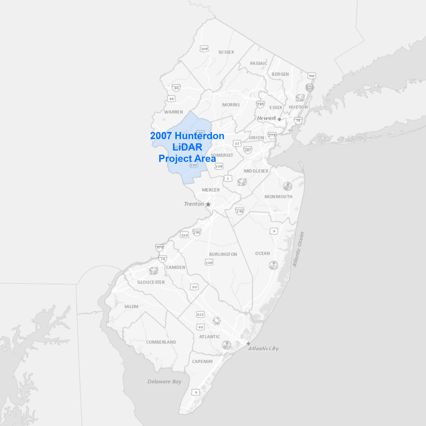 |
The collection area covers Hunterdon County. Data products available for download include:
|
Bulk download data products using the AWS Command Line Interface (CLI)
To download the files, use the AWS Command Line Interface. After installing the CLI, issue commands from your computer's command prompt. In Windows 10, that is found under "Windows System" or by right-clicking the Windows Start button, then click Run, then type cmd into the command line, then click OK. Instructions for download options are provided below:
Download uncompressed classified LAS files
There are 573 files totaling 8.7 GB. Be sure there is adequate storage available on your computer. Once the CLI is installed, list all the files with the following command:
aws s3 ls "s3://njogis-elevation/QL3/Hunterdon_2007/hunterdon_lidar/Lidar All Returns_Point_Cloud/" --no-sign-request --human-readable
Perform a dry run without downloading any files to confirm the CLI is working and the command parameters are correct. Change the c:\LiDAR\ to the local directory into which the files will be copied. To execute a dry run, use the following command:
aws s3 cp "s3://njogis-elevation/QL3/Hunterdon_2007/hunterdon_lidar/Lidar All Returns_Point_Cloud/" c:\LiDAR\ --no-sign-request --recursive --dryrun
Upon a successful dry run, download the files to your computer using the following command (note the omission of the --dry-run parameter used above):
aws s3 cp "s3://njogis-elevation/QL3/Hunterdon_2007/hunterdon_lidar/Lidar All Returns_Point_Cloud/" c:\LiDAR\ --no-sign-request --recursive
The download command will run unattended until completion. It is likely to require several hours (or possibly days) depending on the speed of your internet connection and computer.
Download all data products
There are 9,114 project files totaling 24.9 GB. Be sure there is adequate storage available on your computer. Once the CLI is installed, list all the files with the following command:
aws s3 ls s3://njogis-elevation/QL3/Hunterdon_2007/ --no-sign-request --human-readable
Perform a dry run without downloading any files to confirm the CLI is working and the command parameters are correct. Change the c:\LiDAR\ to the local directory into which the files will be copied. To execute a dry run, use the following command:
aws s3 cp s3://njogis-elevation/QL3/Hunterdon_2007/ c:\LiDAR\ --no-sign-request --recursive --dryrun
Upon a successful dry run, download the files to your computer using the following command (note the omission of the --dry-run parameter used above):
aws s3 cp s3://njogis-elevation/QL3/Hunterdon_2007/ c:\LiDAR\ --no-sign-request --recursive
The download command will run unattended until completion. It is likely to require several hours (or possibly days) depending on the speed of your internet connection and computer.
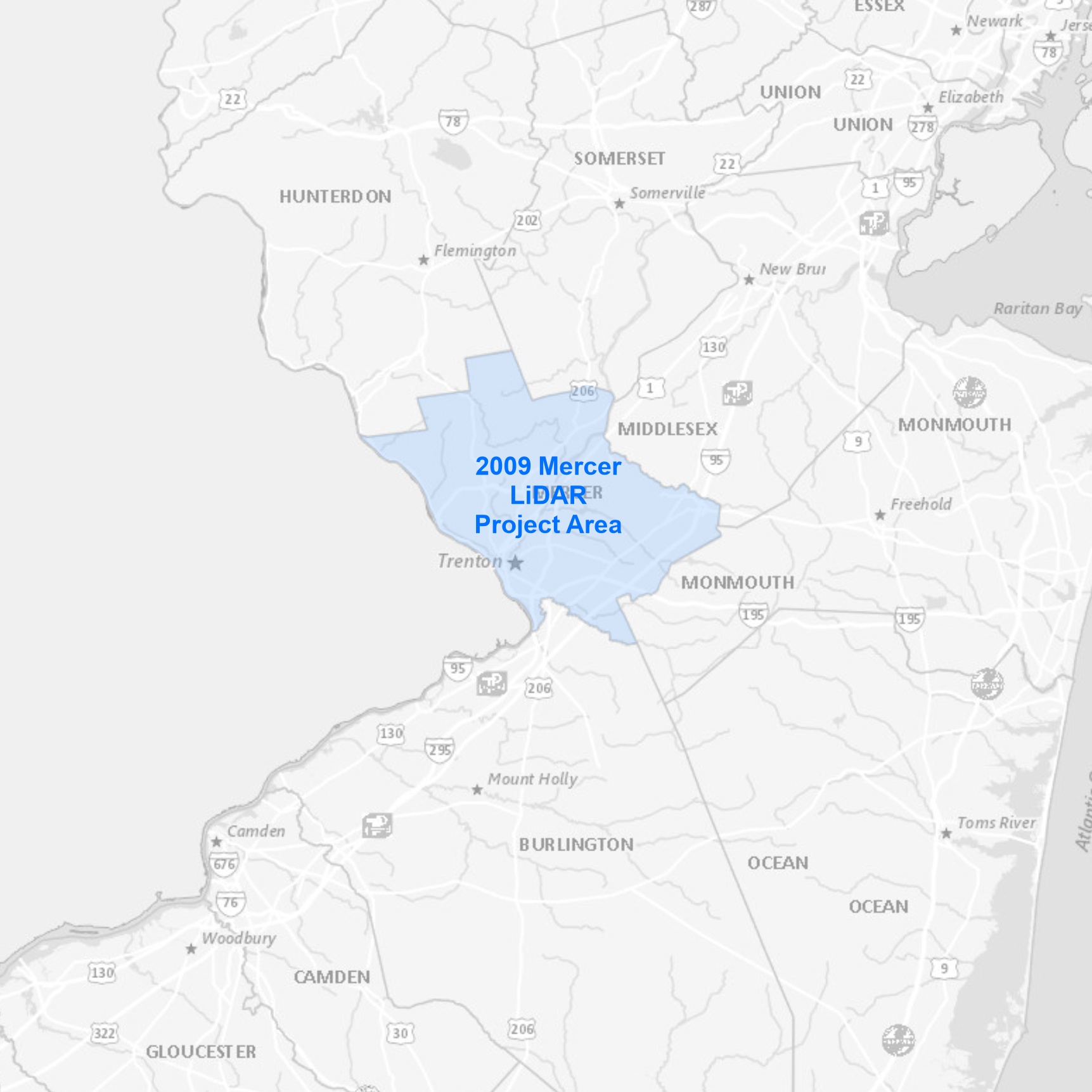 |
The collection area covers Mercer County. Data products available for download include:
|
Bulk download data products using the AWS Command Line Interface (CLI)
To download the files, use the AWS Command Line Interface. After installing the CLI, issue commands from your computer's command prompt. In Windows 10, that is found under "Windows System" or by right-clicking the Windows Start button, then click Run, then type cmd into the command line, then click OK. Instructions for download options are provided below:
Download uncompressed classified LAS files
There are 310 files totaling 89 GB. Be sure there is adequate storage available on your computer. Once the CLI is installed, list all the files with the following command:
aws s3 ls s3://njogis-elevation/QL3/Mercer_2009/Points/MercerCountyNJ_Classified_LAS/ --no-sign-request --human-readable
Perform a dry run without downloading any files to confirm the CLI is working and the command parameters are correct. Change the c:\LiDAR\ to the local directory into which the files will be copied. To execute a dry run, use the following command:
aws s3 cp s3://njogis-elevation/QL3/Mercer_2009/Points/MercerCountyNJ_Classified_LAS/ c:\LiDAR\ --no-sign-request --recursive --dryrun
Upon a successful dry run, download the files to your computer using the following command (note the omission of the --dry-run parameter used above):
aws s3 cp s3://njogis-elevation/QL3/Mercer_2009/Points/MercerCountyNJ_Classified_LAS/ c:\LiDAR\ --no-sign-request --recursive
The download command will run unattended until completion. It is likely to require several hours (or possibly days) depending on the speed of your internet connection and computer.
Download all data products
There are 4,668 project files totaling 127.9 GB. Be sure there is adequate storage available on your computer. Once the CLI is installed, list all the files with the following command:
aws s3 ls s3://njogis-elevation/QL3/Mercer_2009/ --no-sign-request --human-readable
Perform a dry run without downloading any files to confirm the CLI is working and the command parameters are correct. Change the c:\LiDAR\ to the local directory into which the files will be copied. To execute a dry run, use the following command:
aws s3 cp s3://njogis-elevation/QL3/Mercer_2009/ c:\LiDAR\ --no-sign-request --recursive --dryrun
Upon a successful dry run, download the files to your computer using the following command (note the omission of the --dry-run parameter used above):
aws s3 cp s3://njogis-elevation/QL3/Mercer_2009/ c:\LiDAR\ --no-sign-request --recursive
The download command will run unattended until completion. It is likely to require several hours (or possibly days) depending on the speed of your internet connection and computer.
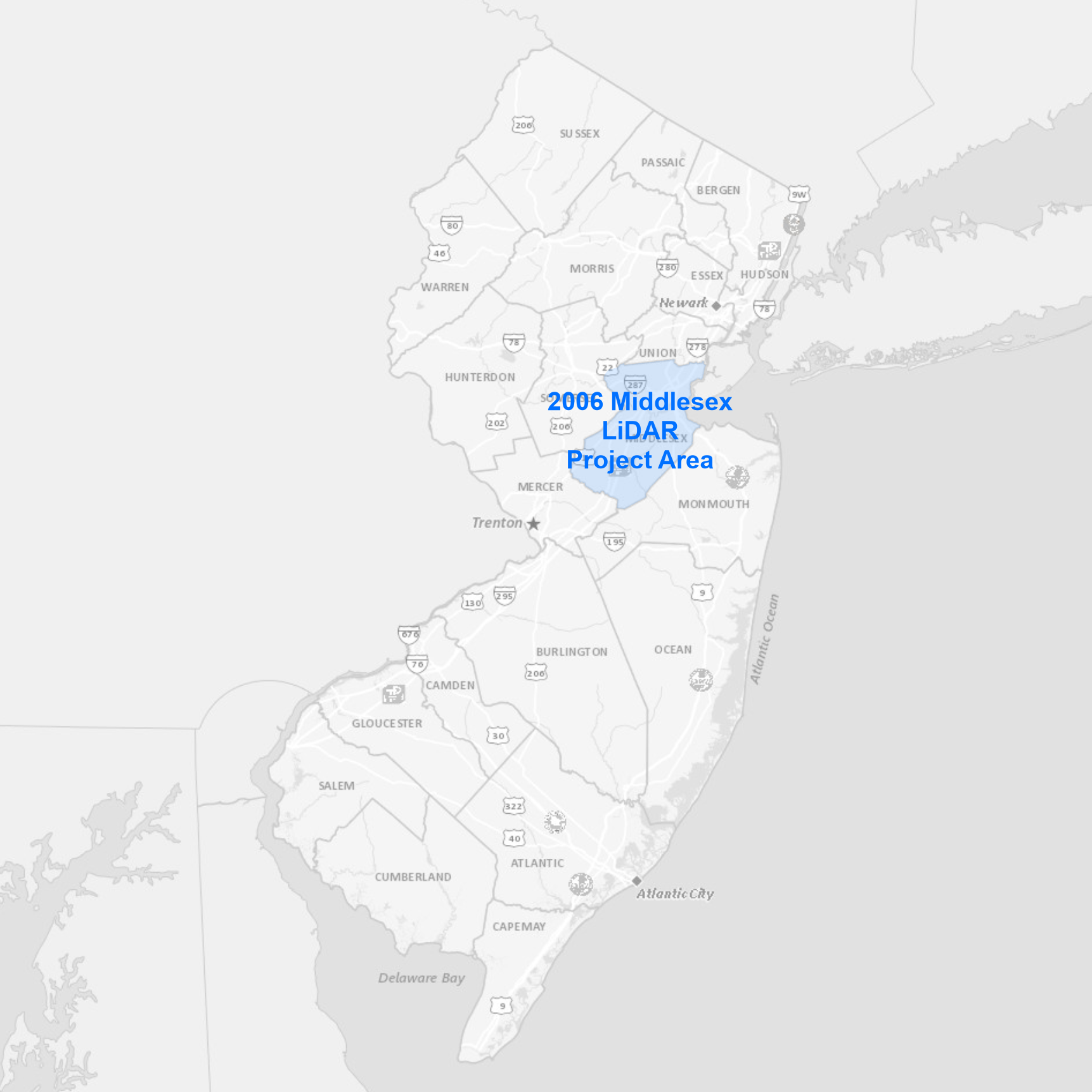 |
The collection area covers Middlesex County. Data products available for download include:
|
Bulk download data products using the AWS Command Line Interface (CLI)
To download the files, use the AWS Command Line Interface. After installing the CLI, issue commands from your computer's command prompt. In Windows 10, that is found under "Windows System" or by right-clicking the Windows Start button, then click Run, then type cmd into the command line, then click OK. Instructions for download options are provided below:
Download uncompressed classified LAS files
There are 38 files totaling 30.4 GB. Be sure there is adequate storage available on your computer. Once the CLI is installed, list all the files with the following command:
aws s3 ls s3://njogis-elevation/QL3/Middlesex_2006/Points/LAS/ --no-sign-request --human-readable
Perform a dry run without downloading any files to confirm the CLI is working and the command parameters are correct. Change the c:\LiDAR\ to the local directory into which the files will be copied. To execute a dry run, use the following command:
aws s3 cp s3://njogis-elevation/QL3/Middlesex_2006/Points/LAS/ c:\LiDAR\ --no-sign-request --recursive --dryrun
Upon a successful dry run, download the files to your computer using the following command (note the omission of the --dry-run parameter used above):
aws s3 cp s3://njogis-elevation/QL3/Middlesex_2006/Points/LAS/ c:\LiDAR\ --no-sign-request --recursive
The download command will run unattended until completion. It is likely to require several hours (or possibly days) depending on the speed of your internet connection and computer.
Download all data products
There are 85 project files totaling 40.8 GB. Be sure there is adequate storage available on your computer. Once the CLI is installed, list all the files with the following command:
aws s3 ls s3://njogis-elevation/QL3/Middlesex_2006/ --no-sign-request --human-readable
Perform a dry run without downloading any files to confirm the CLI is working and the command parameters are correct. Change the c:\LiDAR\ to the local directory into which the files will be copied. To execute a dry run, use the following command:
aws s3 cp s3://njogis-elevation/QL3/Middlesex_2006/ c:\LiDAR\ --no-sign-request --recursive --dryrun
Upon a successful dry run, download the files to your computer using the following command (note the omission of the --dry-run parameter used above):
aws s3 cp s3://njogis-elevation/QL3/Middlesex_2006/ c:\LiDAR\ --no-sign-request --recursive
The download command will run unattended until completion. It is likely to require several hours (or possibly days) depending on the speed of your internet connection and computer.
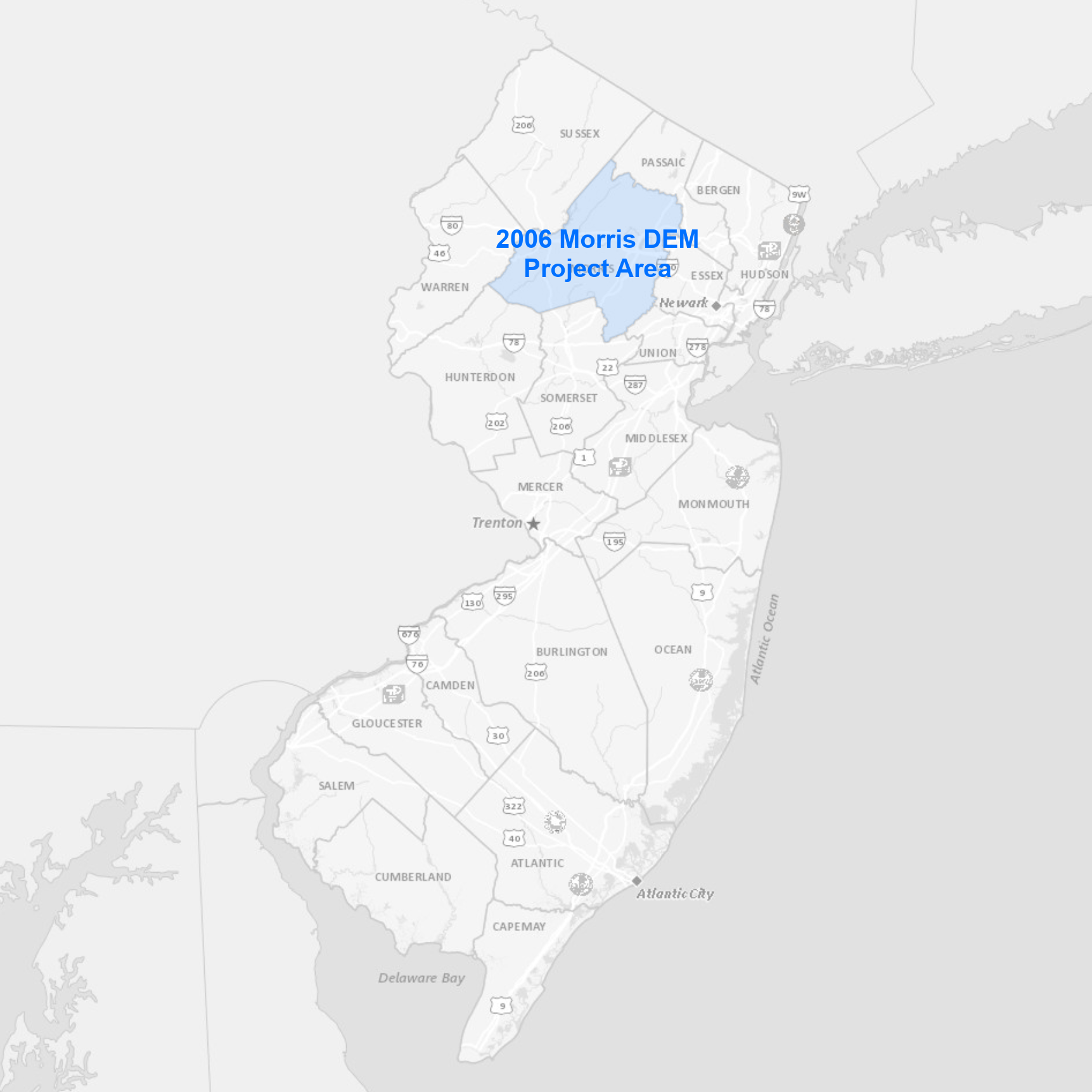 |
The project area covers Morris County. Data products available for download include:
|
Bulk download data products using the AWS Command Line Interface (CLI)
To download the files, use the AWS Command Line Interface. After installing the CLI, issue commands from your computer's command prompt. In Windows 10, that is found under "Windows System" or by right-clicking the Windows Start button, then click Run, then type cmd into the command line, then click OK. Instructions for download options are provided below:
Download all data products
There are 87 project files totaling 11.8 GB. Be sure there is adequate storage available on your computer. Once the CLI is installed, list all the files with the following command:
aws s3 ls s3://njogis-elevation/derived_products/Morris_DEM_2006/ --no-sign-request --human-readable
Perform a dry run without downloading any files to confirm the CLI is working and the command parameters are correct. Change the c:\DEM\ to the local directory into which the files will be copied. To execute a dry run, use the following command:
aws s3 cp s3://njogis-elevation/derived_products/Morris_DEM_2006/ c:\DEM\ --no-sign-request --recursive --dryrun
Upon a successful dry run, download the files to your computer using the following command (note the omission of the --dry-run parameter used above):
aws s3 cp s3://njogis-elevation/derived_products/Morris_DEM_2006/ c:\DEM\ --no-sign-request --recursive
The download command will run unattended until completion. It is likely to require several hours (or possibly days) depending on the speed of your internet connection and computer.
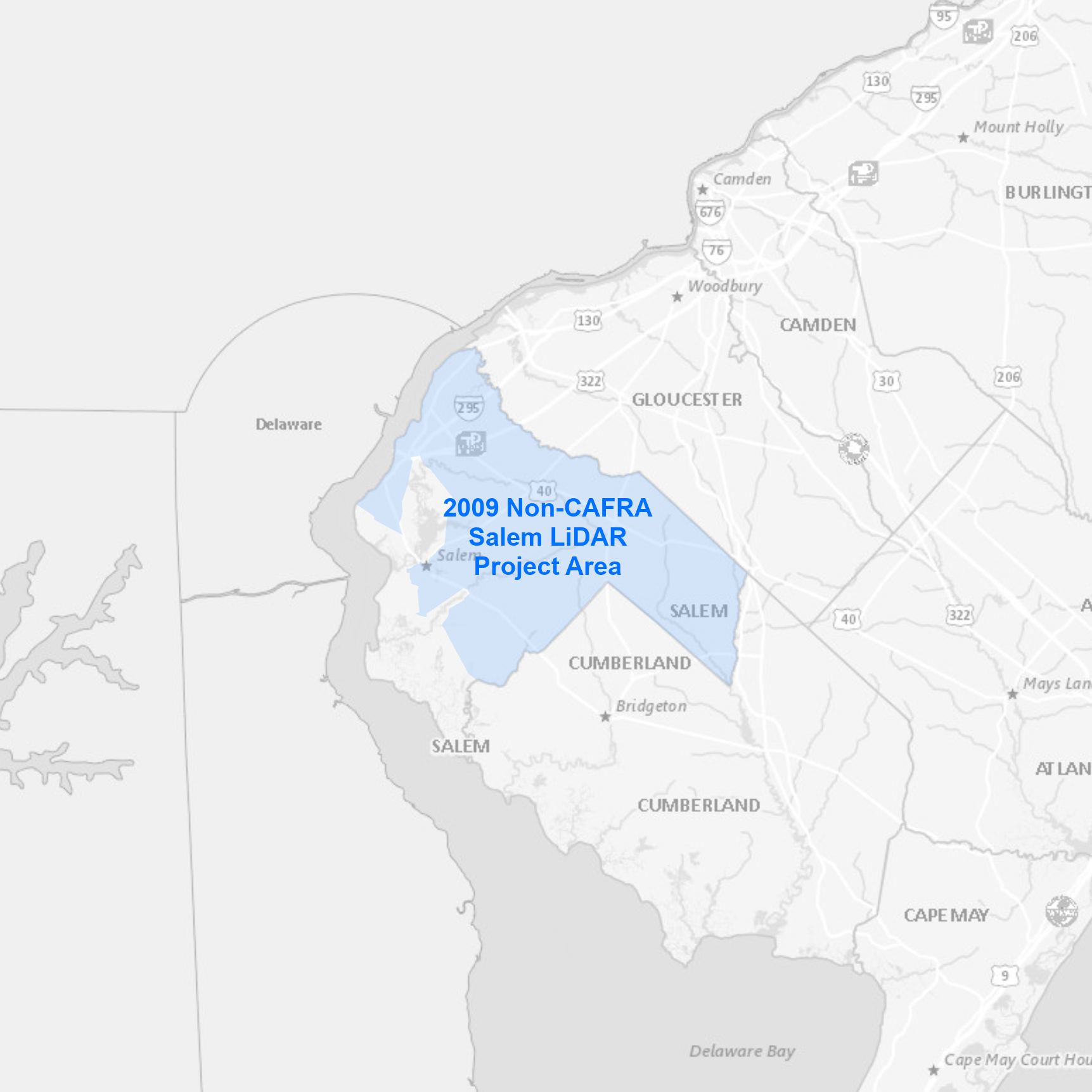 |
The collection area covers non-CAFRA Salem County. Data products available for download include:
|
Bulk download data products using the AWS Command Line Interface (CLI)
To download the files, use the AWS Command Line Interface. After installing the CLI, issue commands from your computer's command prompt. In Windows 10, that is found under "Windows System" or by right-clicking the Windows Start button, then click Run, then type cmd into the command line, then click OK. Instructions for download options are provided below:
Download uncompressed classified LAS files
There are 334 files totaling 67.9 GB. Be sure there is adequate storage available on your computer. Once the CLI is installed, list all the files with the following command:
aws s3 ls "s3://njogis-elevation/QL3/Non-CAFRA Salem_2009/Points/SalemCountyNJ_Classified_LAS/" --no-sign-request --human-readable
Perform a dry run without downloading any files to confirm the CLI is working and the command parameters are correct. Change the c:\LiDAR\ to the local directory into which the files will be copied. To execute a dry run, use the following command:
aws s3 cp "s3://njogis-elevation/QL3/Non-CAFRA Salem_2009/Points/SalemCountyNJ_Classified_LAS/" c:\LiDAR\ --no-sign-request --recursive --dryrun
Upon a successful dry run, download the files to your computer using the following command (note the omission of the --dry-run parameter used above):
aws s3 cp "s3://njogis-elevation/QL3/Non-CAFRA Salem_2009/Points/SalemCountyNJ_Classified_LAS/" c:\LiDAR\ --no-sign-request --recursive
The download command will run unattended until completion. It is likely to require several hours (or possibly days) depending on the speed of your internet connection and computer.
Download all data products
There are 5,056 project files totaling 92.3 GB. Be sure there is adequate storage available on your computer. Once the CLI is installed, list all the files with the following command:
aws s3 ls "s3://njogis-elevation/QL3/Non-CAFRA Salem_2009/" --no-sign-request --human-readable
Perform a dry run without downloading any files to confirm the CLI is working and the command parameters are correct. Change the c:\LiDAR\ to the local directory into which the files will be copied. To execute a dry run, use the following command:
aws s3 cp "s3://njogis-elevation/QL3/Non-CAFRA Salem_2009/" c:\LiDAR\ --no-sign-request --recursive --dryrun
Upon a successful dry run, download the files to your computer using the following command (note the omission of the --dry-run parameter used above):
aws s3 cp "s3://njogis-elevation/QL3/Non-CAFRA Salem_2009/" c:\LiDAR\ --no-sign-request --recursive
The download command will run unattended until completion. It is likely to require several hours (or possibly days) depending on the speed of your internet connection and computer.
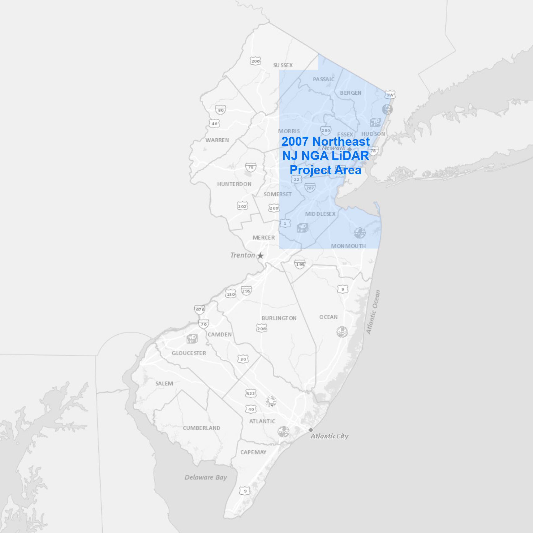 |
The collection area covers the northeast region of New Jersey that includes all or parts of the following counties: Bergen, Essex, Hudson, Mercer, Middlesex, Monmouth, Morris, Passaic, Somerset, Sussex and Union. Data products available for download include:
|
Bulk download data products using the AWS Command Line Interface (CLI)
To download the files, use the AWS Command Line Interface. After installing the CLI, issue commands from your computer's command prompt. In Windows 10, that is found under "Windows System" or by right-clicking the Windows Start button, then click Run, then type cmd into the command line, then click OK. Instructions for download options are provided below:
Download all data products
There are 27,840 project files totaling 83 GB. Be sure there is adequate storage available on your computer. Once the CLI is installed, list all the files with the following command:
aws s3 ls s3://njogis-elevation/QL3/Northeast_NJ_NGA_2007/ --no-sign-request --human-readable
Perform a dry run without downloading any files to confirm the CLI is working and the command parameters are correct. Change the c:\LiDAR\ to the local directory into which the files will be copied. To execute a dry run, use the following command:
aws s3 cp s3://njogis-elevation/QL3/Northeast_NJ_NGA_2007/ c:\LiDAR\ --no-sign-request --recursive --dryrun
Upon a successful dry run, download the files to your computer using the following command (note the omission of the --dry-run parameter used above):
aws s3 cp s3://njogis-elevation/QL3/Northeast_NJ_NGA_2007/ c:\LiDAR\ --no-sign-request --recursive
The download command will run unattended until completion. It is likely to require several hours (or possibly days) depending on the speed of your internet connection and computer.
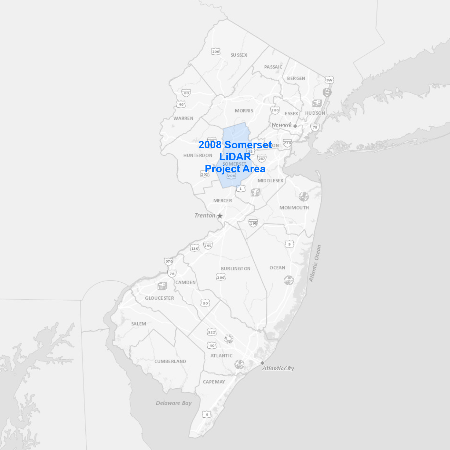 |
The collection area covers Somerset County. Data products available for download include:
|
Bulk download data products using the AWS Command Line Interface (CLI)
To download the files, use the AWS Command Line Interface. After installing the CLI, issue commands from your computer's command prompt. In Windows 10, that is found under "Windows System" or by right-clicking the Windows Start button, then click Run, then type cmd into the command line, then click OK. Instructions for download options are provided below:
Download uncompressed classified LAS files
There are 382 files totaling 59.5 GB. Be sure there is adequate storage available on your computer. Once the CLI is installed, list all the files with the following command:
aws s3 ls s3://njogis-elevation/QL3/Somerset_2008/Points/Las/ --no-sign-request --human-readable
Perform a dry run without downloading any files to confirm the CLI is working and the command parameters are correct. Change the c:\LiDAR\ to the local directory into which the files will be copied. To execute a dry run, use the following command:
aws s3 cp s3://njogis-elevation/QL3/Somerset_2008/Points/Las/ c:\LiDAR\ --no-sign-request --recursive --dryrun
Upon a successful dry run, download the files to your computer using the following command (note the omission of the --dry-run parameter used above):
aws s3 cp s3://njogis-elevation/QL3/Somerset_2008/Points/Las/ c:\LiDAR\ --no-sign-request --recursive
The download command will run unattended until completion. It is likely to require several hours (or possibly days) depending on the speed of your internet connection and computer.
Download all data products
There are 2,429 project files totaling 87.7 GB. Be sure there is adequate storage available on your computer. Once the CLI is installed, list all the files with the following command:
aws s3 ls s3://njogis-elevation/QL3/Somerset_2008/ --no-sign-request --human-readable
Perform a dry run without downloading any files to confirm the CLI is working and the command parameters are correct. Change the c:\LiDAR\ to the local directory into which the files will be copied. To execute a dry run, use the following command:
aws s3 cp s3://njogis-elevation/QL3/Somerset_2008/ c:\LiDAR\ --no-sign-request --recursive --dryrun
Upon a successful dry run, download the files to your computer using the following command (note the omission of the --dry-run parameter used above):
aws s3 cp s3://njogis-elevation/QL3/Somerset_2008/ c:\LiDAR\ --no-sign-request --recursive
The download command will run unattended until completion. It is likely to require several hours (or possibly days) depending on the speed of your internet connection and computer.
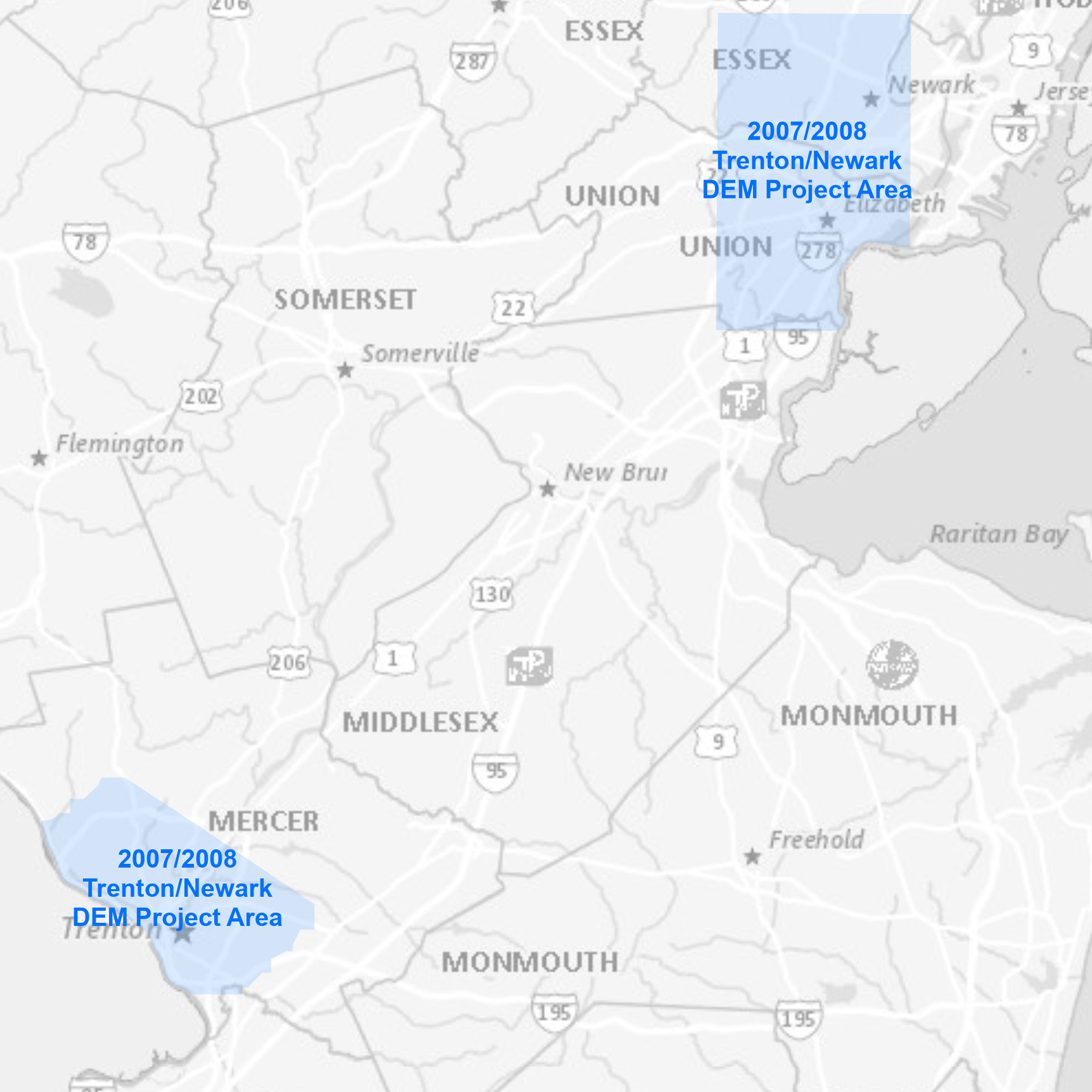 |
The project area covers the Cities of Newark and Trenton. Data products available for download include:
|
Bulk download data products using the AWS Command Line Interface (CLI)
To download the files, use the AWS Command Line Interface. After installing the CLI, issue commands from your computer's command prompt. In Windows 10, that is found under "Windows System" or by right-clicking the Windows Start button, then click Run, then type cmd into the command line, then click OK. Instructions for download options are provided below:
Download all data products
There are 22 project files totaling 2.3 GB. Be sure there is adequate storage available on your computer. Once the CLI is installed, list all the files with the following command:
aws s3 ls s3://njogis-elevation/derived_products/Trenton_Newark_DEM_2007_2008/ --no-sign-request --human-readable
Perform a dry run without downloading any files to confirm the CLI is working and the command parameters are correct. Change the c:\DEM\ to the local directory into which the files will be copied. To execute a dry run, use the following command:
aws s3 cp s3://njogis-elevation/derived_products/Trenton_Newark_DEM_2007_2008/ c:\DEM\ --no-sign-request --recursive --dryrun
Upon a successful dry run, download the files to your computer using the following command (note the omission of the --dry-run parameter used above):
aws s3 cp s3://njogis-elevation/derived_products/Trenton_Newark_DEM_2007_2008/ c:\DEM\ --no-sign-request --recursive
The download command will run unattended until completion. It is likely to require several hours (or possibly days) depending on the speed of your internet connection and computer.
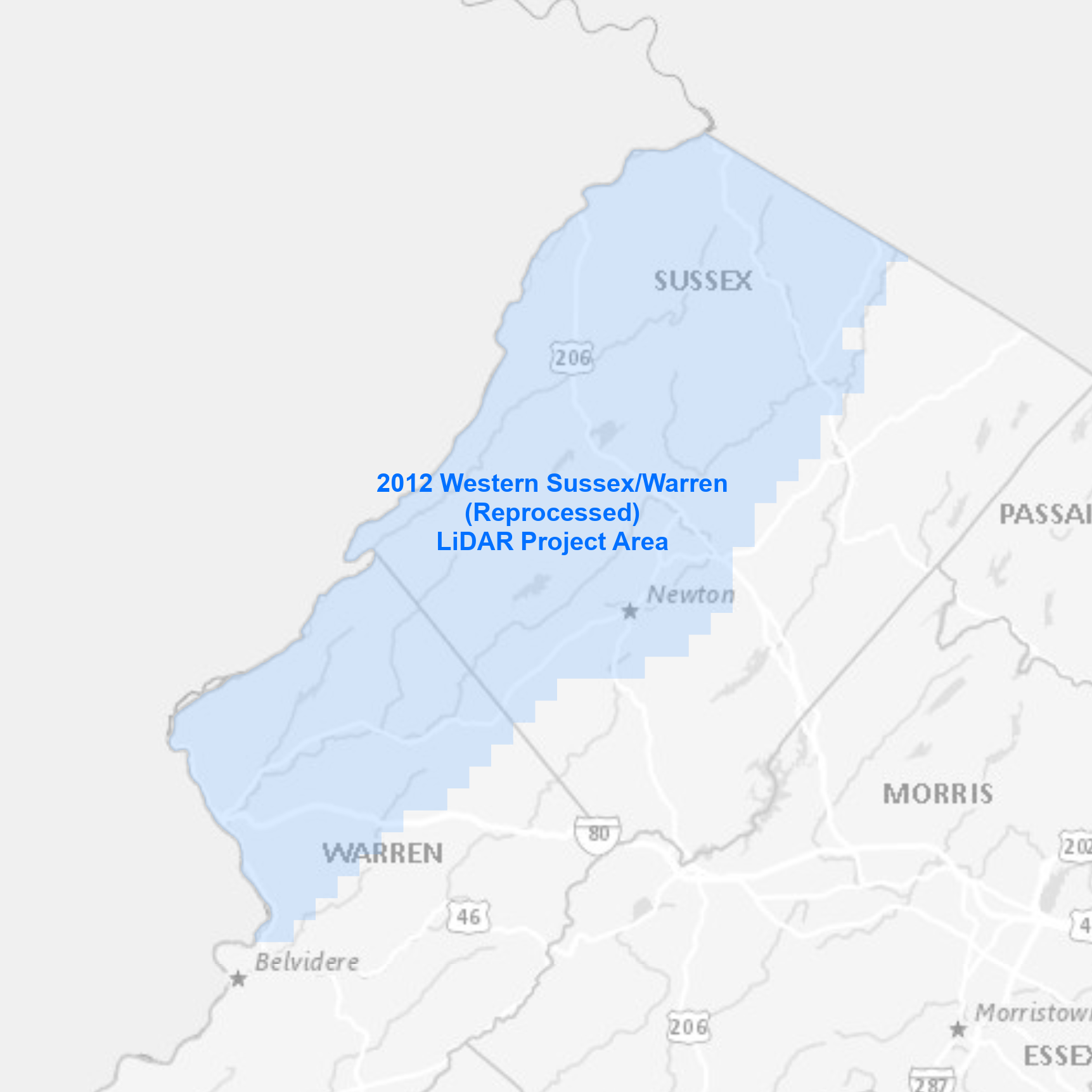 |
The collection area covers western Sussex and Warren Counties. Data products available for download include:
|
Bulk download data products using the AWS Command Line Interface (CLI)
To download the files, use the AWS Command Line Interface. After installing the CLI, issue commands from your computer's command prompt. In Windows 10, that is found under "Windows System" or by right-clicking the Windows Start button, then click Run, then type cmd into the command line, then click OK. Instructions for download options are provided below:
Download uncompressed LAS files
There are 535 files totaling 16.2 GB. Be sure there is adequate storage available on your computer. Once the CLI is installed, list all the files with the following command:
aws s3 ls s3://njogis-elevation/QL3/WesternSussexWarren_Repro_2012/LAS/ --no-sign-request --human-readable
Perform a dry run without downloading any files to confirm the CLI is working and the command parameters are correct. Change the c:\LiDAR\ to the local directory into which the files will be copied. To execute a dry run, use the following command:
aws s3 cp s3://njogis-elevation/QL3/WesternSussexWarren_Repro_2012/LAS/ c:\LiDAR\ --no-sign-request --recursive --dryrun
Upon a successful dry run, download the files to your computer using the following command (note the omission of the --dry-run parameter used above):
aws s3 cp s3://njogis-elevation/QL3/WesternSussexWarren_Repro_2012/LAS/ c:\LiDAR\ --no-sign-request --recursive
The download command will run unattended until completion. It is likely to require several hours (or possibly days) depending on the speed of your internet connection and computer.
Download all data products
There are 1,155 project files totaling 38.1 GB. Be sure there is adequate storage available on your computer. Once the CLI is installed, list all the files with the following command:
aws s3 ls s3://njogis-elevation/QL3/WesternSussexWarren_Repro_2012/ --no-sign-request --human-readable
Perform a dry run without downloading any files to confirm the CLI is working and the command parameters are correct. Change the c:\LiDAR\ to the local directory into which the files will be copied. To execute a dry run, use the following command:
aws s3 cp s3://njogis-elevation/QL3/WesternSussexWarren_Repro_2012/ c:\LiDAR\ --no-sign-request --recursive --dryrun
Upon a successful dry run, download the files to your computer using the following command (note the omission of the --dry-run parameter used above):
aws s3 cp s3://njogis-elevation/QL3/WesternSussexWarren_Repro_2012/ c:\LiDAR\ --no-sign-request --recursive
The download command will run unattended until completion. It is likely to require several hours (or possibly days) depending on the speed of your internet connection and computer.