 Official Site of The State of New Jersey
News Archives
November
New GIS Services Contract RFP released
The Bid Solicitation for NJ’s Geographic Information Systems Services contract (T1841) has been released and is available on NJSTART.
The purpose of this Bid Solicitation to solicit Quotes for Geographic Information Systems (GIS) Services in either of the following categories:
- GIS spatial data development; and/or
- GIS application development and implementation services.
Please visit NJSTART for more information.
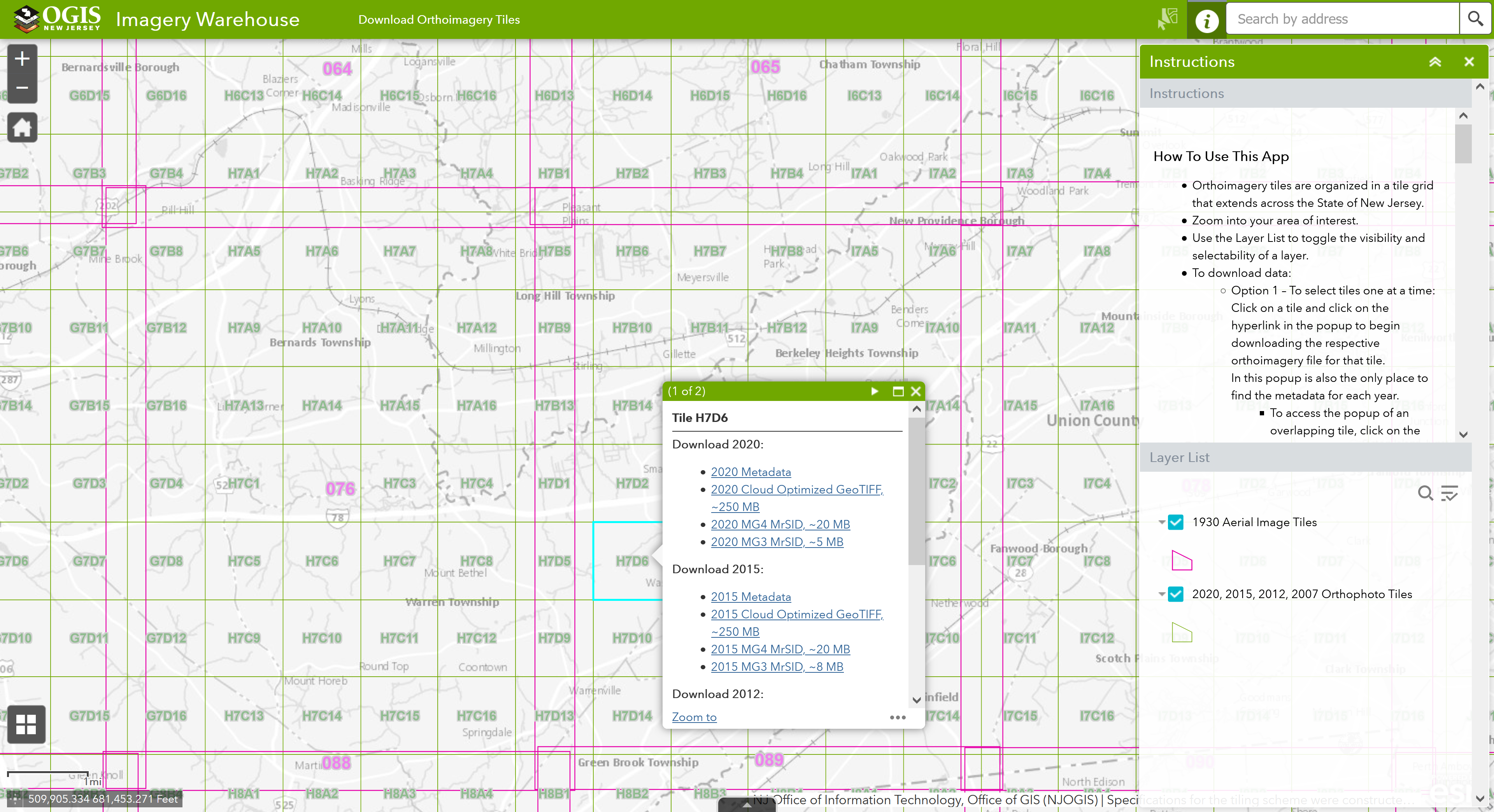
Imagery Warehouse app updated
The Imagery Warehouse application is now live in ArcGIS Experience Builder. Use Imagery Warehouse to interactively download tiles from the most frequently requested imagery collections.
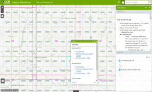
Please note that this is a new URL. The old ArcGIS Web AppBuilder application will be retired on January 31, 2026.
September
NJ Next Gen 911 Grant FY 2026
Select Counties (Burlington, Cape May, Essex, Passaic, and Somerset) that did not apply for FY2025 grant for multi-year GIS Consultant support for Next Generation 911 data management of road centerlines and site address points may apply this year. In your application, please include costs to meet Section IV) A) on page 4 of the grant document. Apply for grant funds by October 31, 2025. Email Brian Embley with questions.
August
NJ Administrative Boundaries Publication Update
To ensure compatibility with ArcGIS Online Hosted Feature Services, additional geoprocessing steps have been applied to the following administrative boundary datasets including the Elementary School Districts, Secondary School Districts, Unified School Districts, Census Blocks, Census Block Groups, and Census Tracts data layers.
For reference, the ArcGIS Online compatibility issue we encountered is that Hosted Feature Services cannot contain Bezier or elliptical curves. When downloaded from ArcGIS Online, this leads to polygons with negative areas. The only remedy at this time is to replace the curves with densified line segments to approximate the curve. We are retaining the curves in our source data internally.
Learn More
Updated Parcels data available for New Jersey
Recent data updates include Burlington, Cape May, Hunterdon, Ocean, and Sussex Counties.
Learn More
April
NJ Administrative Boundaries Publication Update
To ensure compatibility with ArcGIS Online Hosted Feature Services, additional geoprocessing steps have been applied to the following administrative boundary datasets including the Municipal, County, State, Legislative Districts and Congressional Districts data layers.
Several municipal boundary refinements have also been made in conjunction with the recent Statewide Parcels update. For more details, consult the process step lineage of the metadata record.
For reference, the ArcGIS Online compatibility issue we encountered is that Hosted Feature Services cannot contain Bezier or elliptical curves. When downloaded from ArcGIS Online, this leads to polygons with negative areas. The only remedy at this time is to replace the curves with densified line segments to approximate the curve. We are retaining the curves in our source data internally.
Updated NJOGIS ArcGIS Online hosted parcels layer
The Parcels and MOD-IV Composite of New Jersey in Web Mercator (3857) hosted ArcGIS Online layer has been updated with data from the 2023 tax year, along with recent data updates from Egg Harbor Township in Atlantic County, Bergen County, Camden County, Gloucester County, Mercer County, Lincoln Park Borough in Morris County, and Salem County.
Learn More
December
LiDAR downloader apps for 2018 & 2019 data updated
The 2018 Northwest NJ & 2019 South NJ LiDAR downloader applications are now live in ArcGIS Experience Builder. Check them out!
Northwest NJ 2018 LiDAR App
South NJ 2019 LiDAR App
Please note that these are new URLs. The old ArcGIS Web AppBuilder applications will be retired on January 31, 2025.
October
NJ Next Gen 911 Grant FY 2025
Counties and Municipalities with a population over 65,000 residents may apply for funding for multi-year GIS Consultant support for Next Generation 911 data management of road centerlines and site address points. In your application please include costs to meet Section IV) A) on page 4 of the grant document. Apply for grant funds by November 30, 2024. Email Brian Embley with questions.
Learn More
July
New Esri Contract With New Jersey Now in Effect
The New Jersey Office of GIS is pleased to announce that there is a new contract with Esri and the State in place. The contract covers Esri's GIS software and services and can be used by any governmental entity in New Jersey. Information on the contract, such as the current price list and the method of operation, may be found on NJSTART. Please note that there is a new master blanket purchase order number of 25-TELE-82239.
Learn More
June
NJOGIS applications and services to be retired on Monday, June 10
The NJ Office of GIS will be retiring GIS applications and services in favor of hosted (cloud) services capable of high demand and services published by authoritative GIS data stewards. These GIS applications and services will be taken down on or around Monday, June 10, 2024. View the list of retirements at the link below.
Learn More
May
Updated Parcels data available for New Jersey
Recent data updates include Cumberland, Hudson, Middlesex, Monmouth, and Somerset Counties.
Learn More
January
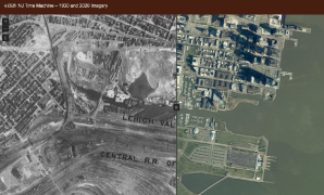
NJ Time Machine App Released – 1930 and 2020 Imagery
The Time Machine application juxtaposes existing statewide orthoimagery libraries from 1930 and 2020 to let users see the changes to the New Jersey landscape over the intervening 90 years.
November
Updated Parcels and MOD-IV data available for New Jersey
The Statewide Parcel and MOD-IV Composite have been updated with data from the 2022 tax year. Recent data updates include Atlantic, Essex, and Somerset Counties, along with new tax Block and Lot numbers for the City of Elizabeth in Union County.
Learn More about updated Parcels and MOD-IV data available for New Jersey
October
New basemap service updates
The color and light gray basemaps were updated to include lighthouse structures, hospitals, and ferry terminals, along with data updates and visual enhancements to existing layers. The parcels basemaps now reflect the latest NJOGIS parcels publication.
Learn More about new basemap service updates
September
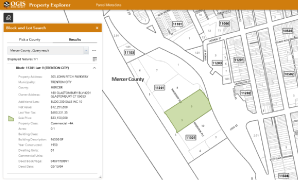
Property Explorer App now out of beta
The NJOGIS Property Explorer application is out of beta and now features improved search performance and an additional lots field.
Learn More about the Property Explorer App now out of beta
June
Updated 2020 orthoimagery tiles
The following tiles were redelivered by Quantum Spatial, Inc. to correct the building lean/shadow issues found in the Atlantic City, NJ area:
| H19B8 | I19A1 | I19A9 |
| H19B12 | I19A5 | I19A10 |
| H19B16 | I19A6 | I19A13 |
Download these tiles (COG, MrSID Gen 2, MrSID Gen 3) from AWS using the Imagery Warehouse or AWS Command Line Interface (CLI). These tiles will be incorporated into the cached map service and WMS layers in the future.
Learn More about tiles (COG, MrSID Gen 2, MrSID Gen 3)
New Statewide derived products
In addition to the existing 2021 Statewide 10 ft DEM and Hillshade, Slope and Aspect datasets are now available for download on AWS using the Command Line Interface (CLI). The latter datasets will be available as image services in the future.
Learn More about New Statewide derived products
Addr_NJ_Cascade geocoding service officially retiring on Monday, July 3, 2023
Please update your records, maps, and web applications to use the NJ_Geocode geocoding service.
May
New Congressional District Finder App
Introducing the new Congressional District Finder! Search by address to locate the extent of the congressional district and find out U.S. Senators and Congressional Representatives.
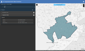
Learn More about New Congressional District Finder App
New and updated layers published by NJOGIS
New layer: Delaware River Islands of NJ and PA
Updated layer: School Point Locations of NJ (Public, Private and Charter)
Learn More about New and updated layers published by NJOGIS
February
Looking for the latest congressional and legislative district boundaries?
Congressional Districts with Office Holder Information, CURRENT
Legislative District Boundaries, CURRENT (with office holder information)
Find these datasets and more on the NJGIN Additional Data Products page.
December
Updated parcels and MOD-IV data available for New Jersey
The Statewide Parcel and MOD-IV Composite have been updated with data from the 2021 tax year. Recent data include Camden, Gloucester, Morris, Ocean, Salem, and Warren Counties, along with new tax Block and Lot numbers for Edison Township in Middlesex County.
Learn More
August
Updated administrative boundaries for NJ
The NJ Office of GIS plans to publish updated county and municipality boundaries and point data on Tuesday, August 23, 2022. Included in the update are a municipality merger and changes to the attribute table field structure for all layers. Users who need details about these changes can find them on the NJGIN Boundaries page.
July
NEW: Property Explorer App
Introducing the new Property Explorer app in beta! Perform parcel searches across NJ by address, county, municipality, block and lot. View parcels with imagery, create a printable report, and download data as a CSV.
June
New NJOGIS road centerlines hosted feature service
Hosted feature service of the statewide road centerlines in the Next Generation 911 format is now available on ArcGIS Online.
Learn More
NEW! Monthly updates from NJOGIS
Beginning June 2022, NJOGIS will update the road centerlines dataset, address points dataset, and statewide geocoding service monthly. View details in the Enterprise Data Updates Report.
May
Maintenance scheduled for NJOGIS imagery services
Due to scheduled maintenance, NJOGIS imagery services may be unavailable on Thursday, May 19, 2022 from noon to 1pm. We apologize for any inconvenience.
April
NJOGIS map services to be retired on Friday, April 29
The NJ Office of GIS will be retiring map services at maps.nj.gov in favor of hosted (cloud) layers capable of high demand and layers published by authoritative GIS data stewards. These map services will be taken down at or around Friday, April 29, 2022.
Learn More
March
POSTPONED: Upcoming NJ administrative boundary changes
The updated county and municipality boundary and point data changes that were scheduled to be published to production on Tuesday, March 29, 2022 are postponed indefinitely. Changes will continue to be available in the test environment for viewing and download.
Learn More
NJOGIS announces new GIO
The NJ Office of GIS welcomes Brian Embley as the new State Geographic Information Officer. He replaces Andy Rowan who held that title for 17 years. Brian also assumes the leadership position at the Office of GIS and is the new GIO member on the NJ Geospatial Forum Executive Committee. He will also represent NJ, as the State GIO, at the National States Geographic Information Council. We wish Brian great success in his new roles!
Learn More
February
2020 statewide orthoimagery available as cached map service
2020 natural color orthoimagery is available as a cached map service through ArcGIS REST and WMTS.
Learn More
December
Maintenance scheduled for NJOGIS map services & applications
Due to scheduled maintenance, NJOGIS map services & applications may be unavailable on Friday, December 17, 2021 from noon to 2pm. We apologize for any inconvenience.
Redaction of owner names from parcels and tax list
The redaction of owner names from parcels and the tax list database is in compliance with the newly enacted Daniel’s Law.
Learn More
Parcels data updates available for download
Parcels data were updated for Bergen, Passaic, Sussex and Union Counties; Montclair Township in Essex County; and Highland Park Borough (block and lot re-numbering) in Middlesex County. All updates were integrated into the Statewide Composite of Parcels.
Learn More
MOD-IV tax list database updates available for download
The 2021 MOD-IV database (for tax year 2020) has been integrated into all parcels datasets and the Statewide Property Tax List.
Learn More
Maintenance scheduled for NJDOT GDMS Viewer
Due to scheduled maintenance, the NJDOT Geotechnical Data Management System (GDMS) Viewer may be unavailable on Friday, December 10, 2021 at 4pm to Monday, December 13, 2021 at 8:30am. We apologize for any inconvenience.
November
Parcels basemap service update
Several counties data in the parcels basemap service were updated.
Learn More
August
Taking Care of Business Site Evaluator to be retired
The Taking Care of Business Site Evaluator web app is due to be retired on Tuesday, August 31st. Many of the datasets used in Site Evaluator will continue to be available for download from NJGIN Open Data.
July
Address points in Next Generation 911 format now available for download and streaming
Address points were reformatted to comply with the Next Generation 911 GIS Data Standard published by the National Emergency Number Association.
Learn More
Legacy LiDAR collections available for download
Legacy LiDAR data collections and derived elevation products for NJ are now available for download
Learn More
2020 statewide orthoimagery collection now available
2020 natural color and color infrared orthoimagery is available through NJGIN download and streaming services.
Learn More
June
New Geocoding Service now available
This new service, NJ_Geocode, leverages enhanced capabilities available in ArcGIS Pro and ArcGIS Server. The previous generation geocoding service, Addr_NJ_Cascade, will continue to be available until December 2021.
Learn More
Road centerlines in Next Generation 911 format now available for download and streaming
Road centerlines were reformatted to comply with the Next Generation 911 GIS Data Standard published by the National Emergency Number Association.
Learn More
Parcels and MOD-IV updates available for download
Parcels were updated for Cumberland, Essex, Monmouth and Sussex Counties, and integrated into an update of the Statewide Composite of Parcels. MOD-IV data for tax year 2019 have been integrated into all parcels datasets and the Statewide Property Tax List.
Learn More
May
Quality Level 2 (QL2) LiDAR collections available for download
Quality Level 2 (QL2) LiDAR data collections and derived elevation products for all regions of NJ are now available for download.
Learn More
April
2015 Imagery in MrSID MG3 format available for download by tile
AutoCAD Users! 2015 imagery in MrSID MG3 (3 band) format is now available for download by tile from the Imagery Warehouse.
Learn More
Maintenance scheduled for NJOGIS map services & applications
Due to scheduled maintenance, NJOGIS map services & applications may be unavailable on Wednesday, April 14th, 2021 at 5PM for approximately 5 minutes. We apologize for any inconvenience.
March
2015 imagery in MrSID MG3 format available for bulk download
AutoCAD Users! 2015 imagery in MrSID MG3 (3 band) format is now available for bulk download.
Learn More
Maintenance scheduled for NJOGIS map services & applications
Due to scheduled maintenance, NJOGIS map services & applications may be unavailable on Monday, March 15th, 2021, at 12PM, for approximately 5 minutes. We apologize for any inconvenience.
February
Maintenance scheduled for NJGIN website, and NJOGIS map services & applications
Due to scheduled maintenance, the NJGIN website and NJOGIS map services & applications will be unavailable on Thursday, Feb. 11th from 5:30am to 7:30am. We apologize for any inconvenience.
January
New NJOGIS parcels/MOD-IV hosted feature service
Hosted feature service of the statewide composite of parcels with MOD-IV attributes is now available on ArcGIS Online.
Learn More
New NJOGIS parcels cached raster tile layer
Cached raster tile layer of the statewide composite of parcels with block and lot labels is now available on ArcGIS Online.
Learn More
New imagery download capabilities available
Interactively download individual imagery tiles using the updated Imagery Warehouse web app or bulk download entire imagery collections using the AWS Command Line Interface
New NJOGIS WMS image services available
WMS services for 2019 USDA NAIP natural color imagery and 1980s USGS NHAP color infrared imagery were added to the NJOGIS image services catalog.
Learn More